The goals of a national assessment are consistent with the mission of the USGS to provide scientific information to support decision-making on issues of resources, environmental quality, and natural hazards. An effort to develop the national indicators of water availability and the water-cycle information should be done in coordination and collaboration with other organizations, Federal and non-Federal agencies, and universities. Collaboration across agency boundaries would ensure that information produced could be aggregated with other types of physical, social, economic, and environmental data that affect water availability. Data that are germane to issues of water availability include water-quality conditions, population statistics, land uses, water costs and pricing, climate data, and instream-flow requirements for aquatic habitats. These data are compiled by State and local agencies, by universities and water-resource organizations, and by several Federal agencies including the Department of Agriculture, the National Oceanic and Atmospheric Administration, the U.S. Army Corps of Engineers, the Bureau of Reclamation, and the U.S. Environmental Protection Agency. Such an assessment could include external research grants and contracts that would be used to improve the methodology and understanding of water availability and to gather, analyze, and disseminate program results.
The assessment should coordinate the design and development of water-availability indicators and water-cycle information through the Federal Advisory Committee on Water Information (ACWI). ACWI members represent 35 organizations from all levels of government (Federal, State, Tribal, and local), public interest groups, academia, private industry, and nonprofit and professional organizations. ACWI is chaired by the Deputy Assistant Secretary of the Interior for Water and Science and is staffed and supported by the USGS under a charter established pursuant to the Federal Advisory Committee Act by Office of Management and Budget Memorandum 92–01. ACWI currently has several subgroups examining water-quality monitoring, data methods and comparability, spatial water data, hydrology, stream gaging, cooperative water programs, and science issues. An additional subgroup should be established to make recommendations on the design and methods of presentation of the proposed indicators of flows, storages, and uses of water and the integration of these indicators with water-quality information and other measures of water availability.
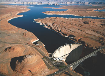
| Glen Canyon Dam impounds the Colorado River and Lake Powell near the Arizona-Utah border. The reservoir storage content of Lake Powell is monitored by the Bureau of Reclamation. Photograph by Michael Collier. |  |
Next: Indicators of Water Availability
| AccessibilityFOIAPrivacyPolicies and Notices | |
 |
|