An assessment should develop and report up-to-date, nationally consistent indicators that would reflect the status and trends in water availability nationwide. Indicators would be developed for surface-water flows and storage, ground-water levels and storage, and water use (table 1). Data sets and analyses produced by the proposed assessment would be posted on the Internet and published in reports and scientific journals. Efforts to develop indicators should comply with the Office of Management and Budget Information Quality Guidelines.
Table 1. Summary of proposed indicators of water availability
|
Surface-water indicators Streamflow: annual and periodic (5- to 10-year) summaries; assessments of long-term trends Reservoir storage, construction, sedimentation, and removal Storage in large lakes, perennial snowfields, and glaciers Ground-water indicators Ground-water-level indices for a range of hydrogeologic environments and land-use settings Changes in ground-water storage due to withdrawals, saltwater intrusion, mine dewatering, and land drainage Number and capacity of supply wells and artificial recharge facilities Water-use indicators Total withdrawals by source (surface water and ground water) and sector (public supply, domestic, commercial, irrigation, livestock, industrial, mining, thermoelectric power, and hydropower) Reclaimed wastewater Conveyance losses Consumptive uses |
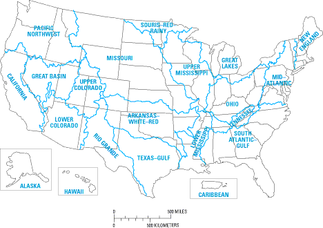
There are several spatial scales at which the indicators of water availability could be reported. Past assessments have focused on the individual States and the 21 major water-resources regions of the United States (fig. 1). Because of technological advances for managing, presenting, and sharing spatial data, it is now possible to provide information at a more refined scale needed by decision-makers.
|
|
| Figure 1. Water-resources regions of the United States (U.S. Geological Survey, 1982). |
An assessment should use the 352 river-basin hydrologic accounting units (fig. 2) as the basis for reporting the national indicators. These accounting units are watersheds that are typically from 5,000 to 20,000 square miles and are used by the USGS for designing and managing the National Water Data Network (Seaber and others, 1987). In most cases, however, boundaries of the hydrologic accounting units do not coincide with those of major aquifer systems. Ground-water variables, therefore, should be reported primarily by major aquifer system.
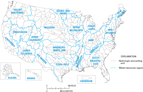 |
| Figure 2. Hydrologic accounting units of the United States (U.S. Geological Survey, 1982). |
|
In testimony before the Environment and Public Works Committee, Subcommittee on Fisheries, Wildlife and Water, on November 14, 2001, Ane D. Deister, Co-Chair of the Interim National Drought Council, identified the following areas as needing coordinated data collection, analysis, and evaluation:
|
Water availability varies seasonally and from year to year in response to changing weather conditions and water-use demands. A meaningful national assessment must remove seasonal and short-term variability to isolate trends and patterns that have regional and national significance. Hence, the status and trends of most indicators should be reported and evaluated every 5 to 10 years. To place these periodic evaluations into long-term perspective, an initial retrospective assessment of the past 100 years should be undertaken to reveal, to the extent possible, changes in water availability during the 20th century. In addition, annual reporting of some indicators, such as surface-water flow, should be done to provide an indication of year-to-year variability of water availability. Monitoring networks for surface-water flow are sufficiently developed to allow for annual reporting and evaluation.
|
Knowledge about hydrologic fluctuations with durations of decades to centuries is important because the lifetimes of man-made water resource systems and of the consequences of resource management decisions are often of comparable duration.
Water Cycle Study Group, U.S. Global Change Research Program, May 2001 |
Back: Coordination and Collaboration
| AccessibilityFOIAPrivacyPolicies and Notices | |
 |
|