Circular 1293
| About USGS / Science Topics / Maps, Products & Publications / Education / FAQ |
Research Opportunities in Interdisciplinary Ground-Water Science in the U.S. Geological SurveyBy W.E. Sanford, J.S. Caine, D.A. Wilcox, H.C. McWreath, and J.R. Nicholas |
This report is written for the scientifically literate reader but is not limited to those who are involved in ground-water science. The report is intended to encourage U.S. Geological Survey scientists to develop a sense of excitement about ground-water science in the agency, to inform scientists about existing and potential ground-water science opportunities, and to engage scientists and managers in interdisciplinary discussions and collaboration. The report is intended for use by U.S. Geological Survey and Department of the Interior management to formulate long-term ground-water science programs and to continue sustained support of ground-water monitoring and research, some of which may not have an immediate impact. Finally, the report can be used to communicate the U.S. Geological Survey’s vision of ground-water science to Congress, partners, other agencies, and the research community at large with the goals of enhancing collaborative opportunities, sharing information, and maintaining dialogue regarding the directions of U.S. Geological Survey ground-water science.
The authors express appreciation to the following for their guidance and review of this report: Bill Van Liew and Louise Liew of the National Park Service; and William M. Alley, Mary Jo Baedecker, Paul M. Barlow, William C. Burton, Kevin F. Dennehy, Norman G. Grannemann, Tien Grauch, Mary C. Hill, Randall J. Hunt, Kenneth J. Lanfear, Randall C. Orndorff, David L. Parkhurst, Herbert A. Pierce, Allen M. Shapiro, Edwin P. Weeks, Thomas C. Winter, and Chester Zenone of the U.S. Geological Survey.
Table of Contents
Ground-Water Research Opportunities
Mapping in Three Dimensions—Geology and Geophysics
Characterizing Aquifer Heterogeneity
Measuring Recharge to Ground-Water Flow Systems
Quantifying Ground-Water and Surface-Water Interaction
Understanding the Relation of Ground-Water Flow Systems to Aquatic Ecosystems
Developing More Effective Computer Models
Figures
Conversion Factors for Units of Measure in this Report
| Multiply | By | To obtain |
|---|---|---|
| Length | ||
| centimeter (cm) | 0.3937 | inch (in.) |
| meter (m) | 3.281 | foot (ft) |
| kilometer (km) | 0.6214 | mile (mi) |
| Area | ||
| square kilometer (km2) | 0.3861 | square mile (mi2) |
| Multiply | By | To obtain |
|---|---|---|
| Length | ||
| foot (ft) | 0.3048 | meter (m) |
| mile (mi) | 1.609 | kilometer (km) |
| Flow | ||
| gallon per day (gal/d) | 0.003785 | cubic meter per day (m3/d) |
By W.E. Sanford, J.S. Caine, D.A. Wilcox, H.C. McWreath, and J.R. Nicholas
The U.S. Geological Survey (USGS) has a long-standing reputation for providing unbiased scientific leadership and excellence in the field of ground-water hydrology and geological research. This report provides a framework for continuing this scientific leadership by describing six interdisciplinary topics for research opportunities in ground-water science in the USGS. These topics build on recommendations of the National Research Council (2000) contained in the report, “Investigating Groundwater Systems on Regional and National Scales,” and emphasize research topics that would benefit from the integrated capabilities of all parts of the USGS. Understanding the relations between ground water and the geological characteristics of aquifers within which ground water resides, and the relation of ground water to surface-water resources and terrestrial and aquatic biota is increasingly important and presents a considerable opportunity to draw on expertise throughout the USGS, including the science disciplines of biology, geography, geology, and hydrology. The National Research Council (2000) also emphasizes that USGS regional and national assessments of ground-water resources should focus on aspects that foster the sustainability of the resource. The need for a comprehensive program addressing the sustainability of ground-water resources can be stated very concisely—we need enough ground water of good quality to sustain our lives, our economy, and our aquatic ecosystems.
Although societal needs for high-quality, objective ground-water science are increasing, current funding for USGS regional ground-water programs is about 40 percent of the funding available 20–25 years ago. Given the current challenges of budgetary constraints, however, this report provides a flexible set of interrelated research topics that enhance the ability of the USGS to focus limited fiscal resources on developing ground-water science tools and methods that provide high-quality, objective scientific information.
The questions that traditional earth scientists generally ask are different from those typically asked by the society we serve. Scientists ask
“What is the current state of the resource?”
“What processes have created this state?”
“How have these processes operated in the past?”
Scientists tend to focus on the present, the past, and the processes.
Society generally wants to know about the future—the present, the past, and the processes are of interest primarily as they relate to the future. Nearly every question about ground water from a private citizen, a municipal planning agency, or a state regulatory agency begins with “What will happen if...?” The “if” leads to a stressor, such as increased water withdrawals, the relation of multiyear droughts to long-term climate change, effects of urbanization, or land-surface contamination. Society’s focus requires that the USGS emphasize science-based forecasting. The USGS must rely on its knowledge of the present, the past, and the processes to provide science-based forecasts based on the effects of stressors yesterday, today, and tomorrow.
Ground-water resources in many parts of the United States are severely stressed by human activity. For example, in the southwestern part of the Nation, large withdrawals result in land subsidence and water shortages. In coastal areas and some inland areas, withdrawals cause saline water to intrude aquifers that formerly contained freshwater. Throughout the Nation, even in water-rich areas, ground water is subject to competing uses where water is insufficient to meet the needs of everyone. Septic tanks, landfills, applications of agricultural chemicals, disposal of chemical and radioactive wastes, and other land uses and activities introduce chemicals to ground water, potentially restrict the use of ground water for drinking, and contaminate aquatic ecosystems in streams, lakes, and wetlands. Furthermore, responses to natural stresses, such as droughts when surface-water supplies often are supplemented with ground water, reduce the availability of ground water for future uses.
Advances in the six interdisciplinary topics for research opportunities in ground-water science described in this report could greatly improve our ability to forecast ground-water availability to sustain human use and support aquatic eco-systems. Briefly, these topics are as follows:
Improved understanding of the geologic framework of ground-water systems through the development of three-dimensional (3–D) mapping and visualization tools and new applications of geophysical methods;
Improved characterization of aquifer heterogeneity in unconsolidated aquifers, fractured aquifers, and karst aquifers;
Improved estimations of recharge, with emphasis on estimates that bridge local and regional scales;
Improved abilities to measure ground-water and surfae-water interactions, which include both inflows to and outflows from ground-water systems;
Improved understanding of the relation between ground water and aquatic ecosystems; and
Improved computer models of ground-water flow and transport, with emphasis on developing and applying new inverse methods and uncertainty analysis.
The first two topics build on the integration of water-resources, mapping, geological, and geophysical characterization research. The next three topics emphasize the importance of quantifying the interactions of ground water with the biosphere and integrating biological and water-resources research. The sixth topic provides a vital link between process-based understandings developed through the other topics and the goal of improved forecasting.
The six ground-water research topics discussed in this report are not intended to be comprehensive, nor do they cover all aspects of ground-water science that will be emphasized by the USGS. These topics focus instead on the need for substantial long-term, interdisciplinary commitment to make the scientific advances that will provide the information needed to support sustainable use of the Nation’s ground-water resources.
The USGS has a central role in ground-water research among Federal agencies and is the sole Federal agency with the mission to conduct nationwide assessments of the status and trends of the surface and subsurface components of the hydrologic cycle. Federal involvement in the assessment of ground-water resources for the Nation is needed to (1) study complete aquifer systems that extend beyond state and international boundaries, because water behaves independently of political jurisdictions; (2) ensure nationally consistent methods of data collection; (3) use and improve the existing monitoring infrastructure; and (4) provide basic research and understanding of the Nation’s valuable ground-water resources. The Federal role is to provide scientific information for states and local agencies to use in managing water resources. Likewise, a Federal role is needed to support the management of large portions of land by the Bureau of Land Management, U.S. Fish and Wildlife Service, National Park Service, U.S. Forest Service, and Department of Defense, and of the land contained within Indian Reservations administered by the Department of the Interior. Several of the topics identified in this report (for example, those addressing karst resources and the effects of ground water on biological resources) are of special concern to other Department of the Interior agencies. The research opportunities emphasized in this report are of interest to university scientists, other agencies, and private organizations. Thus, we see many potential partners in advancing knowledge in these topics.
This publication is intended primarily for persons with a scientific or technical background in the natural sciences, although we attempted to make the report of interest and accessible to a wide audience. The research opportunities contained in this report build on an enormous amount of previous work by scientists within and outside the USGS. For the sake of brevity, we did not attempt to review the literature in the fields discussed, and literature citations are used only to support particular statements.
Mapping in Three Dimensions—Geology and Geophysics
The distributions of lithology and geologic structures in three dimensions are major controls on ground-water flow and solute transport. These physical features, however, usually are complex, difficult to characterize, and even more difficult to visualize. These features also are linked closely to the overall aquifer heterogeneity, the second research topic presented in this report. Consequently, to understand a ground-water flow system fully, the geologic framework must be well understood and incorporated into hydrogeologic analyses and ground-water flow models. As the demand increases for more accurate forecasts of the quantity and quality of ground-water resources, it will be necessary to more accurately characterize the geologic framework.
Geologic mapping constitutes the basic foundation for modern 3–D geologic models. These models are excellent technological tools for representing the natural system by assembling and integrating diverse geologic, geophysical, geochemical, and hydrogeologic information. A critical feature of modern 3–D geologic models developed for process modeling is the representation of uncertainties associated with the geometries and physical properties throughout the model domain and the ability to generate multiple scenarios or realizations. Geologic mapping and field-based characterization; permeability of host-rock and fault-related materials; in-situ borehole and regional geophysical data acquisition; mapping of mineralized and hydrothermally altered rock; cross-section construction; and fracture-network data collection, analyses, and modeling are all used to develop 3–D geologic framework models. The effects of lithologic and structural features on aquifers and the uncertainties involved are investigated in a variety of geologic settings and at a variety of scales ranging from local concerns about a community ground-water supply to regional concerns, such as understanding natural as opposed to mining-related acid and metal loads to surface water, ground water, and aquatic ecosystems. Geochemical, environmental tracer, and ground-water age data also are used in combination with the above information to develop the numerical and predictive models and modeling strategies for ground-water studies. Much of these data also are integrated effectively and explored in sophisticated geographic information systems (GIS) that allow a wide range of users to query multidisciplinary data and generate new and theme-specific earth-science maps.
Geophysical methods are critical for improving knowledge of subsurface geologic structure and lithologic heterogeneities at both local and regional scales. The methods provide information in both horizontal and vertical dimensions and information directly related to hydrogeology and water quality, which can be used to improve knowledge about conditions between wells, extrapolate information to areas away from wells, or provide a mapped view of a large region, such as a watershed or ground-water basin. Developing new applications of ground-based and airborne methods and a better understanding of the relations between physical and hydraulic properties are keys to extrapolating knowledge of the third dimension over wide areas and directly importing this information into ground-water models.
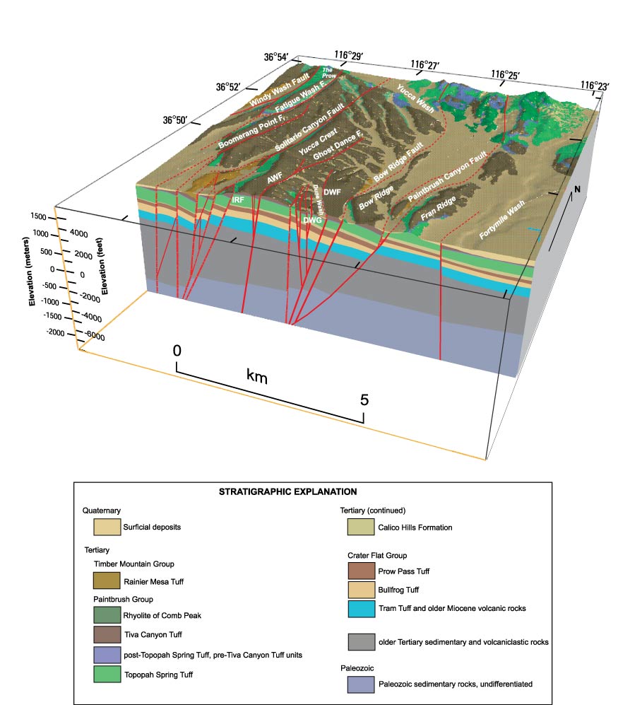
Figure 1. Three-dimensional (3–D) geologic framework model of Yucca Mountain, Nevada (from Potter and others, 2004).
Data used for 3–D framework modeling include geologic maps and cross sections, regional structural and lithostratigraphic facies analyses, geophysical investigations, and lithologic data from boreholes. This block diagram illustrates the geometry of principal structural elements of Yucca Mountain, Nevada. Cross sections, fence diagrams, and block diagrams are traditional tools that geologists use to portray 3–D relations of geologic units and develop a conceptual understanding of the system to be modeled.
Developing a useful 3–D geologic model depends on the use of powerful computer hardware, sophisticated software, and the geoscience tools required to integrate diverse data into a coherent 3–D spatial framework. Modern computer systems handle many complex modeling applications and are evolving rapidly in both speed and storage capacity. Sophisticated software programs are available for assembling, manipulating, and visualizing 3–D geologic maps and models. Driven largely by the needs of petroleum and GIS industries, these programs continue to evolve and stay ahead of the needs of water-resource investigations. Methods and tools for developing 3–D geologic models currently are in the early stages of development, despite the useful knowledge gained from the petroleum industry, but developers of 3–D hydrogeologic models face somewhat different challenges and much additional work.
One of the challenges of 3–D modeling involves improving the scope and utility of geophysical methods that can be applied to hydrogeologic investigations. A variety of geophysical methods are available that can be designed for specific applications, particular scales of investigation, and wide cost ranges. The types of information these geophysical methods provide include characterizing lithology (such as rock type and grain size), determining the boundaries between hydrogeologic units, locating faults that partition units or control ground-water flow, estimating fracture density, mapping hydrothermal alteration or thermal waters, and detecting variations in salinity. Some geophysical methods, such as certain borehole and shallow-looking surface and marine geophysical methods, have become well accepted in ground-water applications. Other methods, such as airborne geophysics, are new to ground-water applications, and their full potential has not yet been developed. Whereas borehole and shallow-looking surface geophysical methods are best for detailed studies, the airborne methods present new opportunities for efficiently and economically characterizing large regions and obtaining information over areas with poor accessibility. This type of information is essential for developing regional 3–D geologic and ground-water flow models.
Research and development are needed to bring 3–D capabilities for geologic modeling to a level that can be integrated routinely with hydrologic models. Methods are needed to (1) quantitatively and probabilistically extrapolate surficial geologic and hydrogeologic information into the subsurface; (2) develop 3–D geologic models of alluvial basins from data typically available in most areas (water wells, drillers’ logs, surficial geology maps, gravity surveys, aeromagnetic surveys, and geotechnical well data and sampling); and (3) define and represent uncertainties in the geometries and properties continuously throughout the rock matrix. New geologic mapping strategies and methods also are needed during the course of routine geologic mapping studies to acquire data important to hydrologic models. Ideally, these strategies and methods will directly use hydrologic data and information as constraints in 3–D geologic mapping.
The ability to determine the relation of geophysical responses to hydraulic properties (hydraulic conductivity, storage, or hydrologic changes) and the means to quantitatively incorporate this geophysical information and interpretation into hydrologic models are needed. Research opportunities in the application of geophysics include the continuing improvement and evolution of geophysical data acquisition and interpretation methods specific to ground-water issues.
Improvements in geophysical methods that result from advancements in mathematical algorithms, visualization, and instrumentation are needed for ground-water studies. The investigation of geophysical responses to variations in hydrogeologic properties entails determining relations between physical properties and hydrogeology, observing the geophysical responses to physical property variations related to hydrogeology, and the difficulty of extending local-scale observations to a regional scale. Finding a relation between geophysical responses and hydraulic conductivity involves understanding which variables affect both and developing means to determine the variables that affect only one. By observing changes in geophysical responses over time, for example, one might be able to isolate the effects of changing water storage or track water-quality changes over time, such as incursions of saline water into coastal aquifers.
Important advancements in modeling capabilities, such as coupling 3–D seismic and other geophysical data and interpretation with hydraulic parameterization routines, will be needed for future ground-water models. A set of techniques that has proved valuable for modeling sedimentary facies architecture in hydrocarbon reservoirs is 3–D seismic and stochastic modeling. During the last decade, petroleum companies have used 3–D seismic techniques to effectively characterize the 3–D geometries of sedimentary facies at the reservoir scale. This requires a great deal of data collection, and for typical petroleum-reservoir scales, the costs easily can be in the millions of dollars for a single survey. Hydrogeologists are just beginning to demonstrate that these techniques have potential for addressing environmental and ground-water issues. Successful test cases have been run in glaciated and alluvial fan settings where contrasts in sediment type are great. The techniques also have been shown to work with seismic cross-hole tomography. Techniques applied to shallower, more local systems than oil reservoirs are being developed along with an improved understanding of how to interpret the signals and results of model simulations. Hydrogeologists are increasingly more aware that to successfully model an aquifer system, equal attention must be paid to using scale-appropriate values of permeability and to correctly defining the geometry of permeability zonation, such as exists in sedimentary formations. Three-dimensional seismic techniques are being used to help define sedimentary zonation on the basis of acoustical properties, which are related in part to hydraulic properties.

Figure 2. Three-dimensional (3–D) images from seismic surveys of the speed of shock waves through sediment (from Hyndman and others, 2000).
The speed of waves is controlled partly by the compressibility of the sediment, which is related to the hydraulic conductivity. Therefore, it may be possible to use seismic images to better map heterogeneity in unconsolidated aquifers.
Characterizing Aquifer Heterogeneity
Despite the importance of knowing the heterogeneity of an aquifer, adequately characterizing it still remains elusive. The nature of aquifer heterogeneity varies with rock type, and different methods will be necessary to improve our abilities to characterize rock types. About half of all the ground water used in the United States is extracted from unconsolidated to semiconsolidated deposits of sand and gravel. Some areas of the Nation rely solely on ground water from fractured-rock aquifers. In addition, many communities that currently rely on surface water and ground water from shallow, unconsolidated aquifers for water supply are evaluating the potential for bedrock aquifers to augment existing supplies.
A key requirement for assessing the sustainability of ground-water systems and their vulnerability to contamination is the spatial distribution of water-transmissive properties. These properties commonly are highly variable spatially as a result of aquifer heterogeneity. Aquifer heterogeneity arises from the complex geologic history of the host rock or sediment. Karst terrains are characterized by extreme heterogeneity and susceptibility to rapid contamination from the land surface. Characterizing the geology as a means of characterizing heterogeneity was discussed in the first topic of this report. The extremely wide range (more than 10 orders of magnitude) of hydraulic conductivity that commonly occurs in ground-water systems leads to the distribution of hydraulic conductivity being the controlling factor in the movement of ground water and contaminants. The representation of hydraulic characteristics of aquifers in models is often sufficient to predict water-level changes in response to stresses, but the same type of representation rarely, if ever, is adequate to determine the flow paths and travel times necessary for contaminant transport studies.
Our current ability to characterize the hydraulic properties of unconsolidated sedimentary deposits and the distribution of these properties is generally adequate for making predictions for water-supply purposes. To predict contaminant migration, however, a much more detailed description of the 3–D pattern of sediment properties is needed. Field studies have shown that, although the extent and movement of contaminant plumes in relatively homogeneous deposits can be delineated and are predictable to a reasonable degree, plumes in heterogeneous deposits are more unpredictable.
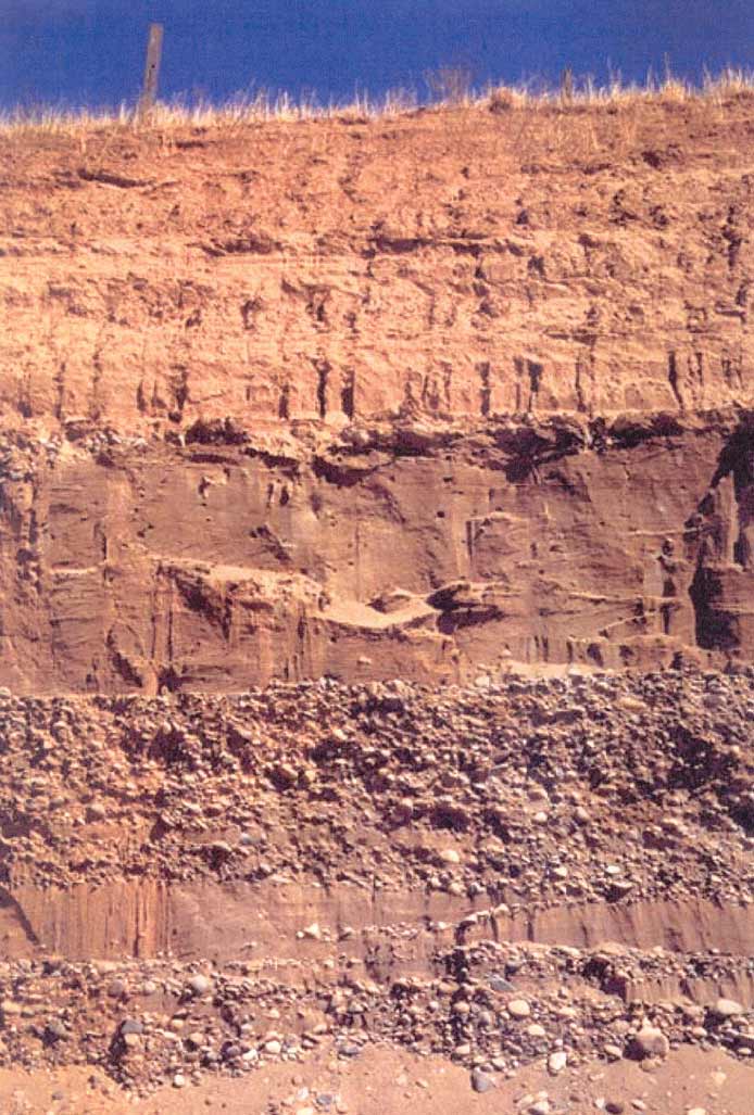
Figure 3. An alluvial deposit near Sacramento, California, that exhibits heterogeneity and vertical anisotropy where a 1- to 2-meter-thick, silty-clay layer at the ground surface is underlain by sand, sandy gravel, and gravelly sand layers. (Photograph from Boulanger and Duncan, 2000)
The heterogeneity of clastic sedimentary aquifers is determined primarily by depositional and burial-related diagenetic processes. Understanding the depositional environments and processes is an important factor in better characterizing these aquifers. Aquifer heterogeneity usually can be characterized by zones, or facies, that are determined to a large degree by the environment at the time of sediment deposition. These facies distributions can vary widely between, for example, riverine, coastal, or glacial environments. Some attempts have been made to use this type of geologic information in creating zones for hydraulic properties in ground-water models. Geostatistical methods have been used to create parameter fields that have statistical properties similar to the sedimentary units of interest.
The heterogeneity of fractured-rock aquifers is determined by the distribution, aperture, and connectivity of fractures. These factors are determined, to some degree, by the tectonic history of the rock and the present-day stress field. Furthermore, the distribution of hydraulic conductivity and storage properties of fractured-rock aquifers can be substantially more variable than those of most unconsolidated aquifers. Borehole investigations (for example, geophysical logging, hydraulic and tracer tests) have been one effective means of characterizing fractured-rock aquifers in the vicinity of the borehole.
Finally, heterogeneity in karst terrains is determined by the distribution of solution channeling along fracture networks that eventually develop into cavernous openings. Thus, it is important to know the locations of transmissive fractures, individual caves, and other solution openings in order to delineate flow paths. To this end, field studies in karst terrains have shifted from quantitative modeling to field-based, tracer techniques. Quantitative characterization of this rock type has been difficult, not only because of the extreme heterogeneity but because of the variability in types and degrees of solution channels involved. A combination of geophysical methods, tracer tests, and special modeling approaches has been giving the best results.
A better understanding of depositional environments and processes is needed to improve characterization of sedimentary aquifers. Current approaches to characterizing heterogeneity in clastic sedimentary aquifers are relatively simplistic, and efforts will need to be made to understand how the distribution of hydraulic conductivity is determined by grain-size distributions in space, the sorting of grain sizes, the arrangement of sedimentary facies, and post-depositional burial- and exhumation-related diagenesis.
Research will need to focus on understanding the control that fault zones and other structures, such as folds, have on a ground-water flow system. The identification of faults in the subsurface, their geometry, variations in hydraulic properties, and the boundary conditions that they impose on a flow system are poorly understood. Predicting hydraulic properties caused by faults is particularly difficult. A framework for understanding the effects of faulting on hydraulic properties would include alternative and combined approaches, such as (1) extrapolation of structures from the surface to the subsurface, (2) delineation of the geometry of faults in three dimensions, (3) determination of the permeability distribution of faults, and (4) delineation of the geologic processes that currently affect fault-related hydraulic properties, such as stress fields, heat, and diagenetic processes.
Information synthesized from multiple characterization methods is needed to develop a conceptual understanding of aquifer heterogeneity and its control on ground-water flow and contaminant movement. The extremely heterogeneous nature of fractured rock makes it difficult to apply conceptual approaches and field techniques that have been used with more homogeneous unconsolidated aquifers. In fractured rock, historical and current regional and local stress fields control the occurrence of geologic structures and fractures; fractures are the predominant pathways for fluid movement. Joints, bedding-plane partings, and sometimes faults commonly are referred to as fractures and are not distributed uniformly through rock, thus making assumptions that commonly are applied to unconsolidated porous media, such as homogeneity and anisotropy, inappropriate. Also, because individual fractures can have spatially varying characteristics and the connectivity of fractures can be highly complex, hydraulic properties of fractured rock do not vary smoothly in space. Because of the extreme heterogeneity in fractured rock, no single technique or interpretive approach can be used to explicitly and unambiguously map the spatial distribution of hydraulic properties that control fluid movement and chemical migration.
Crystalline rocks and some low-permeability sedimentary fractured rocks are characterized by low porosity and low specific storage, which imply that the volume of water in bedrock aquifers is not necessarily sufficient for sustained water supply. Sufficient well yields require drawing water from either a huge volume of the bedrock or from adjoining formations with higher porosity, such as overlying unconsolidated geologic materials (typically not suitable in mountainous and upland areas where few deposits of this type are present). Thus, the ability to sustain a water supply from a fractured-rock aquifer depends as much on the surficial geology and topographic controls as on the presence of highly permeable fractures in the bedrock. Identifying the factors that control the interdependence of surficial geology on bedrock aquifers is of great importance in managing ground-water resources. Identifying the potential water supply from a bedrock aquifer frequently is approached at the scale of a well field, where fractures of suitable transmissivity are sought in production wells. Well yields depend to a large extent, however, on the surface area of high permeability fractures and their ability to garner water from more pervasive, less permeable fractures in the formation.
Geologic controls on ground-water flow over increasingly larger dimensions must be investigated in different geologic settings, and methods of inferring hydraulic properties of bedrock with confidence need to be developed over increasingly larger scales through a combination of geologic, geophysical, geochemical, and hydrologic methods. Several theoretical investigations have proposed that the hydraulic conductivity of bedrock aquifers increases with increasing scale; however, field evidence indicates otherwise.
A better understanding of the magnitude of the contaminant mass that is constrained within the intrinsic porosity of rocks (and bound to fracture surfaces) could lead to more realistic ground-water remediation approaches that do not necessarily rely on ground-water withdrawal. Highly heterogeneous aquifers commonly contain zones of relatively stagnant water. These stagnant zones can influence chemical transport, because chemicals can diffuse from active flow zones into the stagnant zones. This is analogous to diffusive mass transport between fractures and the unfractured rock matrix—a process often referred to as matrix diffusion. In situations when fractured-rock environments are considered as sites for waste isolation, matrix diffusion is regarded as a positive attribute. In contrast, matrix diffusion is regarded as a negative attribute when ground-water restoration is considered, because removal of a contaminant from the primary porosity is limited by the rate of diffusion; thus, the achievement of acceptably low concentrations of the contaminant could take centuries.
Additional emphasis needs to be given to more comprehensive and quantitative methods for characterizing and predicting flow and transport in karst terrains. Although tracer tests are valuable for locating potential flow paths, they have limited transfer value to other locations or for covering larger regions under different hydrologic conditions. One promising modeling approach has been to incorporate the cave or fracture network directly into deterministic flow and transport models by treating the network as a special type of boundary condition. A combination of open-channel flow in underground streams and porous-media flow in the rock matrix also can be represented using a coupled ground-water and surface-water model. Geophysical science has provided useful tools, including ground-penetrating radar, for field mapping and detecting transmissive caves, fractures, and fracture networks in locations that are otherwise inaccessible. Combining different field and(or) modeling techniques also is possible. For example, tracer tests could be combined with electrical resistivity surveys, or tracer breakthrough curves could be used to help calibrate parameters in transport models. Work also needs to continue in recognizing karst features and characterizing the degree to which different types of features affect flow in the aquifer system. Characterizing karst aquifers remains one of our most difficult challenges. Developing a variety of techniques and improved understanding of where each technique works best is likely to bring the most progress in improving characterization of aquifer heterogeneity.
Measuring Recharge to Ground-Water Flow Systems
The sustainability of ground water as a resource is an important issue for many communities throughout the Nation. Ground water is recharged naturally by rainfall and surface water. Under steady-state conditions, the amount of recharge to an aquifer system balances the discharge, and the amount of recharge determines the rate at which water and any associated contaminants move through the system. Thus, determining the amount of recharge is useful for determining water availability and transport rates in ground-water systems.
Two critical factors of recharge are the temporal and spatial distributions of recharge. With quantitative values of these factors, one can estimate the total volume of water entering a system. In the more arid, western parts of the country, the temporal and spatial distributions of recharge are more difficult to quantify. Recharge also is a function of evapotranspiration, which makes the accurate measurement of evapotranspiration critical. In the past, we have relied on monitoring ground-water levels as an indicator of recharge; for a more complete characterization in the future, we need to focus on developing methods to measure recharge fluxes to ground-water systems.
Recharge is estimated by using a climatological and hydrologic budget approach in which rainfall, runoff, evapotranspiration, and changes in soil moisture and ground-water storage are measured, and recharge is calculated as the residual. Because errors in the measured terms accumulate into the recharge term, this approach is inaccurate.
Methods for measuring recharge based on the physics of water movement in porous media have been available for decades. These methods measure the water content or water-bearing properties of subsurface materials but tend to provide point measurements that do not necessarily reflect subsurface conditions at regional scales. Lysimeters can be used to keep track of the total water budget in an isolated volume of the subsurface. Borehole geophysical tools can be used to measure the water content of a vertical profile through time; these data then can be interpreted to determine net downward water flux. Water levels in shallow wells can be analyzed to estimate recharge from rainfall and evapotranspiration from ground water. Finally, the unsaturated hydraulic conductivity of rock or soil can be measured at very low saturations using centrifuges, and if a unit hydraulic gradient is assumed, the values can be converted to recharge rates.
On a more regional scale, stream hydrograph separation has been used for decades to estimate recharge; geophysical techniques, such as microgravity, electromagnetics, and ground-penetrating radar, have been used only more recently. Another approach has been to use ground-water models to estimate the recharge based on some degree of certainty assumed for the other model parameters. Recharge estimates for such models improve when ground-water age data are available to constrain ground-water fluxes. Rainfall-runoff watershed models also have been used to estimate recharge and the effects of climate change on recharge. Research efforts that are currently underway to couple watershed models with variably saturated subsurface-flow models will improve estimates of ground-water recharge rates and our understanding of the effects of climate change on the timing and amounts of ground-water recharge.
Both naturally occurring and anthropogenic environmental tracers have been useful in providing a means of dating ground water, determining recharge rates, and in some cases, determining recharge source areas. The mass balance of chloride in precipitation and soils has proven to be useful in determining recharge on an areal basis. The natural radio-active tracer 14C is useful in dating ground water in the range of 1,000 to 50,000 years, and the radioactive isotope 36Cl is useful in dating ground water in the range of thousands to hundreds of thousands of years. Anthropogenic environmental tracers, introduced into the atmosphere by above-ground testing of nuclear weapons (3H, 3He, 36Cl, 14C, and 85Kr, for example) and by industrial activities (chlorofluorocarbons), are useful in dating ground water that is less than 50 years old.

Figure 4. Simulated values of average annual net ground-water recharge in Southeastern Florida (from Langevin, 2001).
Direct measurements of recharge usually are made at the local scale at individual field sites. Ground-water models can provide valuable regional information, however, by estimating the magnitude and spatial distribution of ground-water recharge and discharge.
The USGS will need the expertise to build upon the results of research in meteorological and agricultural disciplines to improve estimations of recharge for ground-water modeling and other hydrologic applications. Remote-sensing imagery has a role in identifying, delineating, and quantifying variability in land cover, soil moisture, and vegetation. The U.S. Department of Agriculture and the academic community have conducted substantial research in the use of remote sensing to estimate the energy and water fluxes that occur between land and the atmosphere. Landsat satellite data are used to identify and delineate land-cover types and vegetation types. Geostationary Operational Environmental Satellite (GOES) data are used to estimate insolation and energy fluxes. Surface-energy balance components have been evaluated by combining satellite remote-sensing data with on-site measurements of solar radiation, air temperature, wind speed, and vapor pressure.
Research is needed to understand better the various physical and chemical processes in the variably saturated zone. The variably saturated zone between land surface and the water table is a critical region in which infiltration mobilizes and spreads contaminants into the ground-water system. Understanding a variety of different physical and chemical processes in the variably saturated zone is an essential prerequisite for the design of cost-effective remediation efforts on contamination from different sources, including chemical spills, leaking underground storage tanks, drainage of leachate from waste-disposal sites, and applications of agricultural chemicals. Another environmental concern is the long-term migration of radionuclides from low- and high-level nuclear waste-disposal facilities. Variably saturated conditions in fractured rock present an even more complicated flow-path system than in unconsolidated rock, which can lead to transport calculations based on different conceptual models. The development of more sophisticated flow and transport processes in variably saturated flow models will be a key requirement for designing remediation and containment strategies.
Improved efficiency and capability in collecting and analyzing ground-water age tracers will lead to improved estimates of recharge rates. One of the most promising techniques for quantifying recharge is using ground-water age tracer data in an inverse-modeling approach. Currently, age determination is limited to ground water either less than 50 or between about 1,000 and 50,000 years old. Use of the radioisotopes 39Ar and 32Si has the potential to aid in filling the ground-water age gap between 50 and 1,000 years, but further research on both techniques is needed to improve corrections for potential natural sources and to reduce the volume of water needed for analysis. Other techniques are on the horizon for dating ground waters older than 50,000 years. The radioisotope 36Cl continues to be investigated, but more research is needed to quantify better its natural sources and long-term changes in atmospheric deposition. The radioisotope 81Kr has a half life of 225,000 years, and challenges in the analytical detection of this element are just beginning to be overcome. Finally, radioisotope 129I has a half life of 16 million years; thus, its detection has the most potential for improving the accuracy of age dating deep-basin waters.
Stochastic approaches are needed to address the spatial variability in soil and rock types and the resulting variations in recharge rates. Recharge fluxes are important quantities, not only for water-resource planning but to help predict potential contamination of water supplies from nonpoint sources. Agricultural contaminants, for example, move through the variably saturated zone before reaching the water table, and the arrival time at the water table is directly dependent on the vertical flux of water through the variably saturated zone. These approaches involve the use of Monte-Carlo techniques to simulate a wide range of parameter values, with the result being a related range of chemical concentrations. This range of predicted concentrations then can be quantified in terms of the uncertainty or likelihood that a given chemical will contaminate a given site by a specified time. Ongoing developments in coupled watershed and subsurface-flow models will improve estimates of spatially variable fluxes of water and contaminants through the unsaturated zone, which will help to provide a basis for stochastic analysis of agricultural contamination of ground-water systems. Another potentially powerful modeling approach is the combination of GIS and soil-type data bases with nonpoint-source contamination studies. Progress is likely to occur over the next several years as we begin to combine the stochastic approach for predictions with GIS-based models.
The long-term hydraulic response of the aquifer system and the geochemical effects of mixing water of different chemistries need to be studied at pilot test sites and through numerical simulation. In order to supplement the natural recharge to aquifer systems, water managers and engineers have proposed for some time the artificial recharging of aquifers using either ground water or surface water. Most such projects are characterized as aquifer storage and recovery (ASR) and involve injecting or infiltrating water into permeable aquifers and recovering the water later during times of high demand. The use of ASR still poses many technical challenges, however. A large-scale ASR project currently is being proposed as a partial solution to the water needs of southern Florida and the Everglades (National Research Council, 2001). If this ASR project goes forward, more than 1.7 billion gallons per day of surface water will be injected into a permeable saline aquifer through more than 300 wells.
Methodologies are needed to incorporate predictions of changes in rainfall and evapotranspiration made with global climate models into recharge calculations for ground-water models. The amount of water available to recharge a ground-water system is strongly dependent on rainfall and evapotranspiration, which in turn are dependent on climate. Long-term changes in climate are, therefore, likely to affect recharge to aquifer systems and eventually long-term water-management plans. As population growth is expected to stress the world’s water resources, decreases in rainfall are predicted to be greatest in the mid to low latitudes, where most of the world’s population lives. Predictions of changes in rainfall, evapotranspiration, and recharge can be made with global climate models linked with watershed and subsurface-flow models. Additionally, because rainfall intensity affects runoff, climate and watershed models can be used to predict changes in runoff, which also affect ground-water recharge rates. Water managers need accurate forecasts for water availability to plan for growth and water use. Given an understanding of the spatial variability of recharge, models that address water-availability trends can be developed, and forecasts with such models can improve as our ability to predict potential climate change improves. Ground-water studies also can help us understand changes in recharge that occurred during past climate changes, thus improving our understanding of the response of recharge to climate change.
Quantifying Ground-Water and Surface-Water Interaction
Under natural conditions, most ground water discharges into a body of surface water—a stream, river, lake, or ocean. The spatial distribution and magnitude of the discharge can have a large effect on the surface-water body and its eco-system. Recognition is growing that ground water and surface water must be treated as a single system, because stress that is applied to either one is likely to affect the other. For example, pumping wells can lower stream levels, river floods can affect ground-water levels, and chemical contamination can move from ground water to surface water or the reverse. Evapotranspiration is a major component of the hydrologic budget at sites of ground-water and surface-water interaction, and our ability to quantify this component affects our ability to quantify the interaction.
Although past studies have focused on understanding the theory and potential for ground-water and surface-water interaction, more recent studies have focused on trying to measure fluxes. A standard method for identifying regions of interaction has been to monitor ground-water levels in shallow observation wells near surface water. Differences between ground-water and surface-water levels indicate discharge or recharge conditions. To quantify flux, however, a value for the vertical permeability of the sediment—a value that is not easy to measure accurately—is required. In an attempt to measure flux directly, seepage meters were developed to collect a volume of water in a submerged bag attached to a cylinder that captures the discharge flowing through the sediment. Although seepage meters will continue to be useful in measuring ground-water discharge to surface-water bodies, the disadvantage of this technique is that many point measurements are required to obtain an integrated representative value.
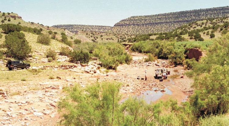
Figure 5. USGS scientists installing instrumentation in an ephemeral stream at Abo Arroyo, New Mexico, to monitor streamflow and calculate recharge using temperature as a tracer. (Photograph courtesy of David Stonestrom, USGS, Menlo Park, California)
In the western United States, arid conditions often lead to ground-water recharge being concentrated along mountain fronts in losing reaches of perennial or ephemeral streams. Estimating recharge from these streams is important for water-availability studies, and the use of temperature as a tracer is proving to be a valuable method.
In the measurement of surface- and ground-water interaction, temperature recently has been a useful property. By recording temperature profiles beneath streams, the transient diurnal temperature signal in the surface water, which reflects the air temperature, can be observed moving down through the subsurface. The shape and lag time of this signal are dependent on the downward water flux. Chemical tracers also are used to identify regions of ground-water and surface-water interaction. The natural isotopes of hydrogen and oxygen, for example, commonly indicate differences between the water bodies that can be used to identify the different sources of water. Neither temperature nor isotope techniques, however, quantify the fluxes. More recently, the dating of young ground water has been used to help quantify fluxes from surface-water bodies.
Much work has gone into trying to estimate or measure evapotranspiration. Most studies have focused on one of three methods—the chamber method, the energy-budget method, or the eddy-correlation method. These methods are applied at a local scale and can be useful in measuring evapotranspiration from different types of vegetative cover at different sites.
Improved expertise in bridging soil, vegetation, and atmospheric modeling with hydrologic modeling would be useful in achieving a fuller understanding of the ground-water component of the hydrologic cycle. Recent attempts have been made to couple climate models with water-resources models. Coupling these models requires evapotranspiration rates that are appropriate for the subregional to regional scale.
Advancements in a variety of techniques to measure flux and identify discharge areas need to be applied to ground-water studies. Efforts continue to improve the standard seepage meter and expand its use to new environments. Some promise is being shown in coupling borehole magnetometers to seepage meters, whereby continuous-flux measurements can be made remotely for longer times. Additional advances also are being made in the use of temperature as a tracer. For example, temperature signals can be recorded using small inexpensive temperature loggers that can fit in a 1- to 2-inch-diameter borehole, which makes it possible to instrument an entire site at a reasonable cost. This technique especially is useful in arid and semiarid regions where recharge often is concentrated in perennial or ephemeral streams (fig. 5), although applications in more humid regions also show promise. It is likely that this technique will be used in more studies as details of its efficiency emerge and as tools are developed to analyze the large amounts of data that typically are collected. For example, an automatic parameter-estimation program and a one-dimensional transport model show promise in estimating recharge when time-series data are entered.
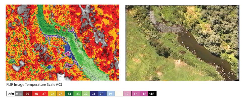
Figure 6. Remote sensing image showing cold (blue) temperatures that reveal ground-water discharge to the Umatilla River in Oregon, August 10, 1998. (Photograph courtesy of Watershed Science, Inc., under contract to the Oregon Department of Environmental Quality)
The temperature of discharging ground water often differs from the temperature of surface water, which makes temperature an obvious indicator of discharge locations. Temperature also is an important environmental factor controlling fish habitat.
Thermal-infrared imaging can be effective in identifying and delineating areas of ground-water discharge. The temperature of ground water discharging into a surface-water body—a stream, lake, marsh, or bay—commonly is different from the surface-water temperature. Ground-water discharge to mountainous streams and lakes can be detected by large-scale thermal imagery because of the temperature difference between warm ground water and cooler surface water. Thermal-infrared images include tonal differences that aid in delineating the location and extent of diffuse and concentrated ground-water discharge. Thermal-infrared imaging can help in interpreting zones of ground-water discharge to surface-water bodies when more conventional, intrusive techniques are not available. Thermal-infrared imaging can be used to detect ground-water discharge to coastal, saline waters when suitable temperature contrasts and sufficient rates of ground-water discharge occur. The feasibility of this technique, however, has many constraints. The imaging must be done when weather conditions maximize temperature contrasts between discharging ground water and surface water. Thermal sensors respond to energy from only the uppermost portion of an emitting body and cannot penetrate vegetation. Only an unobstructed view of the ground allows correlation of the detected radiant flux to temperatures on the land surface. Over water, thermal imagery records the radiant flux of approximately the upper millimeter of the water surface.

Figure 7. Four images of different sections of the San Pedro River basin from a thermal infrared multispectral scanner (TIMS) used to calculate evapotranspiration and recharge at land surface. (The colors represent reflected infrared (thermal) wavelengths.) (Images provided by National Aeronautics and Space Administration/Advanced Spaceborne Thermal Emission and Reflection Radiometer Science Team)
Evapotranspiration is an important component of the energy budget at land surface. The evapotranspirative flux can create temperature anomalies that can be detected by remote sensing and used to estimate fluxes and their spatial distribution, especially when the remotely sensed data are combined with field measurements.
The focus of research in evapotranspiration must shift from making local measurements to obtaining average regional values. Remote sensing has been used by the USGS in Nevada to extrapolate evapotranspiration measurements on a regional basis (Laczniak and others, 1999). In another study, an approach that correlates ground-water evapotranspiration with a modified soil-adjusted vegetation index derived from Landsat data was used to develop a method for estimating the magnitude and distribution of ground-water evapotranspiration at a regional scale (Nichols, 2000). The area of each vegetative cover type was multiplied by the evapotranspiration measured at a site representative of the vegetative cover type. In Florida, evapotranspiration measurements made as part of the South Florida Ecosystem Initiative have been used to correlate evapotranspiration rates with various discrete wave bands of remotely sensed data (Desmond and others, 1999).
Substantial research external to the USGS needs to be coupled with USGS investigations to develop a comprehensive set of methods and approaches with regard to evapotranspiration rates derived from remotely sensed data (fig. 7). Researchers in other government agencies and academia have investigated the use of remote sensing to estimate energy and water fluxes between the land and atmosphere. In one such study, a method for estimating regional evapotranspiration by using synoptic weather data and satellite imagery was explored (Sucksdorff and Ottle, 1990). Soil moisture and evapotranspiration correlate highly with the radiometric surface-temperature component of the energy balance at the land-atmosphere interface. Soil moisture and evapotranspiration can be estimated by combining thermal infrared imagery, in-situ measurements of surface and atmospheric properties, and surface-energy flux modeling.
Rigorous research is needed for both the benefits and constraints of using remote sensing for determining evapotranspiration. Study results have shown direct correlations between evapotranspiration and density of photosynthetically active vegetation, as defined by the leaf-area index. Leaf-area index, as expressed by the Normalized Difference Vegetation Index (NDVI) data from satellite imagery, however, apparently does not correlate directly to all ecosystem landscapes. A USGS study in the Florida Everglades demonstrated that NDVI and evapotranspiration appear to be inversely related (German, 2000).
Understanding the Relation of Ground-Water Flow Systems to Aquatic Ecosystems
Ground water is an important component of the water budget in aquatic ecosystems, including wetlands, rivers, streams, lakes, and coastal areas. Ground water also is critical in determining water quality and has an important role in habitat development and maintenance for a variety of aquatic and semiaquatic organisms. As noted in the National Research Council (2000) report on ground-water systems, research is leading to a better understanding of the interactions of ground water and surface water, and the USGS has led much of the research. Until recently, however, ground-water research has focused on hydrology and geology. Ecologists have been slow to embrace ground water as an integral component of their interdisciplinary research, or have had difficulty incorporating ground-water studies into their ecological research. Ecologists generally are not prepared to conduct ground-water studies, and hydrologists generally are not prepared to conduct ecological studies. Collaboration, therefore, is critical in the research of aquatic ecosystems, from understanding the underlying geology and associated hydrology to the biological and biogeochemical systems they support.
In 1975, the eminent river ecologist H.B.N. Hynes challenged the scientific community to relate the biota and processes occurring in streams and rivers to the physical processes linking surface waters with their watersheds, including surface-water and ground-water interactions. In subsequent studies, scientists recognized that the distribution of biota is related to ground-water discharge to surface water and surface-water recharge to ground water. At about the same time, other work was laying the foundation for increased understanding of the interaction of lakes and ground water. The results of this work caught the attention of ecologists, particularly those who realized the need to understand the hydrologic characteristics and processes of lakes and ground water in order to understand better the biogeochemical processes and biota in these waters. Wetland studies conducted by ecologists 20 years ago rarely included detailed examination of hydrologic processes, including interaction with ground water. Over the decades, some ecologists and hydrologists began to collaborate to gain a better understanding of wetland ecosystems. These studies have advanced the knowledge of wetland functions and processes and could serve as models for how such interdisciplinary work can be achieved.
The scientific hydrologic community increasingly recognizes that ground water and surface water are a single resource. A recent USGS report (Winter and others, 1998) serves as a guide on this subject for wetland and aquatic professionals, the general public, and governmental decisionmakers. The report addresses ground-water and surface-water interactions in terms of natural processes, such as the hydrologic cycle, chemical interactions, and landscape features; and in terms of human activities, such as agriculture, urban and industrial development, drainage, and modifications to river valleys and the atmosphere. Each of these topics has implications for aquatic ecosystems and biota. Determining the source of water, the resultant water chemistry, and the ultimate response of biological organisms in any aquatic system requires an understanding of the ground-water component of the hydrologic cycle, which often varies according to landscape setting. Moreover, in many settings, the biological processes can appreciably influence the hydrologic components (for example, evapotranspiration and enhanced recharge as a result of bioturbation). Thus, ecological understanding is needed to understand fully the hydrology. Evaluating the effects of human activities that alter watersheds, airsheds, landscapes, and individual wetland and aquatic settings requires an understanding of the contribution of ground water to both the natural and modified conditions. Factors ranging from changes in water level to contaminant transport can greatly affect wetland and aquatic biota and are often dependent on ground-water flows.
Research incorporating ground-water hydrology in ecological studies related to human activities generally has been site specific. Examples include studies of the dewatering effects of ditching wetlands or pumping nearby wells; aquifer-contamination effects from agricultural, industrial, and residential development; effects of water and rock interactions in metal-rich, mineral deposits that load aquatic ecosystems with highly acidic waters and toxic metals; and landscape-level effects from clearcutting to saltwater intrusion and land-use change in a watershed. Not only can human activities reduce or increase exchange between ground water and surface water, but they can reverse or sever the exchange altogether. In most local studies, the specific nature of the ground-water component of hydrology is unique, and it is the fine-scale aspect of hydrology that often dictates the ecological effects. Therefore, generalizations about ground-water flow are not adequate to explain site-specific ecological conditions. Other applications of ground-water hydrology to ecology include wetland restoration, construction of wetlands for mitigation purposes, and development of an “abiotic” wetland- classification system, such as the hydrogeomorphic (HGM) approach. Other studies have focused on a variety of methods employed in understanding the relation of ground water to aquatic ecosystems and on developing models. Although ecological research that incorporates studies of ground-water hydrology is increasing and includes wetlands, rivers, streams, lakes, and coastal areas, the research generally is localized and specific, and results are not linked to results of other studies.
The challenge for the USGS in integrating ground-water studies with ecological studies is in fostering collaborative research opportunities among scientists from different disciplines. Specific environmental concerns need to be identified that require integrated research related to ground-water and ecological science. Initially, studies of many aquatic ecosystems could be reviewed to identify the geologic framework, including the ground-water and surface-water hydrologic components of the framework, as a means of enhancing understanding of the biological and biogeochemical systems that are an integral part of the land and water. A further progression would be to generate useful products from these aquatic studies, including models and maps showing 3–D relations among the interactive components replete with enough data to include as many variables and processes as needed for relevance to the ecosystems. Where data are not available, scientists from all disciplines could generate conceptual models that could be used to guide research efforts targeted at filling the gaps in our understanding. In all cases, studies of the relation of ground water to aquatic ecosystems should have both a temporal and spatial perspective and be geared to improve forecasting whenever possible.

Figure 8. The Texas Blind Salamander, Typhlomolge rathbuni, lives only in the caves of the Edwards aquifer, an important source of water, and is listed as endangered by both the State of Texas and the Federal government. (Photograph courtesy of Joe N. Fries, U.S. Fish and Wildlife Service)
Endangered species of fish, birds, reptiles, and amphibians inhabit waterways throughout the Nation. More and more habitats are coming into conflict with increasing stresses on our finite water resources.
Research is needed to understand better the role of various hydrologic components at various scales in order to forecast changes in water budgets of local aquatic ecosystems affected by human activities. Recent work has improved the understanding of evapotranspiration as a component of water budgets, but more work is necessary. Additional information is needed to understand the effects of ground-water withdrawals and artificial recharge on wetlands, rivers, lakes, and other aquatic resources. Urban development and landscape-scale paving of surfaces reduce ground-water recharge and increase stormwater runoff and related sediment transport. The resulting redistribution of water is affecting aquatic ecosystems at discharge locations. Alteration of surface-water hydrology (for example, dams, diversions, and channel modifications in fluvial systems) similarly can affect recharge, discharge, and aquatic ecosystems. The greatest issue related to water budgets, however, is the potential effects of climate change. For example, the amount of precipitation reaching different geographic regions is likely to change, thus affecting recharge and discharge ecosystems. Recent history indicates an increase in the frequency of extreme precipitation events. Thus, within any given range of precipitation, stormwater runoff is likely to increase, recharge of ground water is likely to decrease, and discharge of ground water subsequently is likely to decrease. In addition to the immediate ecological effects of altered surface-water hydrology, this scenario has implications for ground-water hydrology, especially in wetlands. Warm air temperatures enhance evapotranspiration. This, along with reduced precipitation, can rapidly affect wetlands dependent on surface water, including those that recharge ground water. Wetlands supplied by ground water, however, can remain wet during short-term changes and continue to support biological communities. Long-term reductions in recharge, however, ultimately affect the ability of these wetlands to serve as refuges during warm climatic periods when evapotranspiration is greatest. In general, little is known about the ground-water component of flow and the ecological dependence on this flow for most of the Nation’s wetlands.
Forecasting changes in water quality in aquatic ecosystems that are influenced by human activities requires a better understanding of ground-water interactions. Ground-water withdrawal along or near coastal areas may result in saltwater intrusion into freshwater aquifers, which may affect the distribution and quality of aquatic ecosystems. Recharge areas, which can be as important to ecosystems as discharge areas, can be contaminated directly by industries, mining, spills, or urbanization. Other more pervasive influences require further investigation to gain a holistic concept of potential effects, including (1) contributions of nutrients to ground water from agriculture, septic fields, and lawns in urban areas; (2) contributions of pesticides from agricultural and residential sources and concentrations of dissolved constituents in return flow from irrigation and water-reuse systems; and (3) deposition of a variety of contaminants from the atmosphere. Moreover, these chemical stressors rarely occur in isolation, and the effects of combinations of stressors are not well understood.
More research is needed to determine the ability of wetland and riparian areas to improve surface-water quality. Knowledge of hydrologic sources, transformations, and processes is fundamental in understanding, assessing, and monitoring the health of aquatic ecosystems. For example, ground-water inflows in a natural or constructed wetland system have been related to root-zone temperature, time and duration of freezing, water levels and range of fluctuation, and carbon profiles. Yet little information is available. Although ground water may be considered in water-management plans (for example, source water for filling and sustaining impoundments) and in plans for construction or restoration of wetlands, a greater understanding of hydrologic processes and dependencies is needed before ecological studies can fully integrate ground-water hydrology. Many biological organisms are affected by water-quality conditions in areas where ground water is a dominant forcing function (for example, salinity). Finally, more information is needed on ground-water flows, biogeochemistry, and biological communities associated with the interfacial “hyporheic” zone between ground-water and surface-water systems. In many cases, the chemical transformations that occur in the interface zone over a few centimeters can overwhelm the transformations that occur in kilometers of upgradient ground-water flow.
Developing More Effective Computer Models
The first five research topics in this report are focused on developing a better understanding of the framework and processes of ground-water systems, their relations to aquatic ecosystems, and ways of adapting and improving methods to extract information from these systems. Additional research on any of these topics can contribute to improving the capabilities of ground-water simulation models. Although assumptions must always be made in constructing simulation models and the amount of data will always be limited, no other tool can integrate the available knowledge of a system to the same extent. As computer speed and storage continue to increase, modeling programs will be developed to represent more effectively the structural framework and dynamic processes of ground-water systems. Future modeling efforts also need to quantify better the uncertainty inherently associated with forecasting. In order to manage the resource for sustainability, society needs to be able to forecast responses of ground-water systems to the ever-increasing stresses being imposed on them. Hydrologic forecasting has been listed as one of the most important challenges in the environmental sciences. To use ground-water resources more efficiently, we need to be able to predict changes in water levels, discharge, and the movement of contaminants. To make informed forecasts, all available data regarding a ground-water system must be brought together and analyzed simultaneously in a framework that defines the physics and chemistry of how water and solutes move in the subsurface. This is best done by using computer simulation models.
The USGS is a leader in the development of ground-water simulation computer codes. MODFLOW, the USGS modular ground-water model (Harbaugh and others, 2000; Hill and others, 2000), is one of the most widely used ground-water models in the world. Ground-water modeling software has improved from describing predominantly two-dimensional (2–D) ground-water flow or geochemical equilibria in the 1970s to 3–D flow and 2–D transport of chemicals (or water-rock interactions) in the 1980s to 3–D flow and transport, one-dimensional (1–D) reactive transport, and inverse modeling and parameter estimation in the 1990s. As the 21st century begins, computer modeling has expanded to include simulation of 3–D transport for studies involving seawater intrusion and reactive contaminants. For water-resource planning, ground-water flow and transport-simulation models also have been coupled with management (or optimization) models from the field of operations research. Such simulation-optimization models simultaneously account for the physical processes of a ground-water system and the water-resource management aspects of the system.
Another aspect of modeling in which simulation advancements have been made is the coupling of ground-water and surface-water models. Traditionally, simulation models of hydrologic systems have focused on either the ground-water or surface-water systems. Ground-water models did not account for land-surface hydrologic processes, such as precipitation, evapotranspiration, and overland runoff; whereas, surface-water models either did not account for the contributions of ground water to surface-water flow or, in the case of watershed models, accounted for ground-water storage and discharge using very simple formulations. An important exception to this generalization is the development of computer programs that simulate leakage between ground-water systems and hydraulically connected surface-water features by applying Darcy’s Law. These programs range in complexity from simple approaches that do not include flow in the surface-water features to more detailed approaches that either track flow in a network of streams that interact with the ground-water system or that formally couple 1–D, unsteady streamflow-routing models to a ground-water flow model. Although these programs are extremely useful for simulating flows between ground water and surface water, they do not account for the important land-surface processes typically simulated by watershed models, such as the USGS Precipitation-Runoff Modeling System (PRMS; Leavesley and others, 1983).
One of the most challenging aspects of coupling ground-water and surface-water models has been the representation of water flow through the unsaturated zone. Typically, models of subsurface flow assume instantaneous recharge of water infiltrating the land surface to the water table, even in areas that have a thick unsaturated zone. Recently, however, investigators have made progress in developing numerical methods that account for the storage and transit time of water through the unsaturated zone, and one of these methods is being implemented in the development of a coupled watershed and ground-water flow code using the PRMS and MODFLOW models.
The trial-and-error approach often used in the past to calibrate ground-water models is ill-suited for calculating optimal parameter values, model uncertainty, and the relative importance of individual observations. Parameter-estimation models that use nonlinear regression or related methods better address these calibration issues. Parameter-estimation codes were developed initially with the intent that the type of observations that could be used in the estimation would be limited to water-level and flow data. These data usually are sufficient for convergence of the nonlinear regression routines; in actual case studies, however, the data often are dominated by water-level information, yielding high parameter correlation and uncertainty.
More recent development of universal inverse modeling programs, such as the USGS program UCODE (Poeter and Hill, 1998), make it possible to calibrate ground-water models using, for example, geophysical or geochemical data. Because inverse methods require a large number of individual model simulations, the computational speed requirements are appreciably greater than the computation speed required for a single forward-model simulation. To date, this requirement has limited the size and complexity of a model that can be calibrated using automated calibration. Calibrations have been confined mostly to ground-water flow models, as transport models require finer grids for stable and realistic simulations and, thus, more computations. This limitation is slowly but steadily being overcome by increasing speeds and storage capabilities of computers. Therefore, it is probable that over the next several years it will be possible to apply inverse methods to models that simulate multidimensional transport and dispersion of solutes at real field sites using realistic ranges of transport properties. Such calibrations will include other computationally demanding processes, such as geochemical reactions or multiphase flow and transport.
Another valuable piece of information that comes from inverse modeling is the identification of the relative value of individual observations. Sensitivity analyses from parameter-estimation methods reveal not only the observations that give the most information regarding the different parameters of the model, but also the new observations that give the most valuable information for improving parameter estimates. These results also can be related to parameters that give the most information regarding the model predictions. This is critical information in the design of data-collection or monitoring networks. Financial resources are always limited, but cost effectiveness and value will be enhanced by knowledge of the types of data that are needed and where data will be more useful. Long-term costs associated with monitoring hydrologic systems can be minimized and the benefit maximized by using such an analysis from the inverse-modeling approach. Currently, these types of analyses are in the early stages of development, and additional development and application with test cases is likely to be of great benefit to society over the next several years.
Hydrologic modeling and hydrologic research go hand-in-hand. Simulation of ground-water flow systems, including surface-water and ground-water interactions, their relation to ecosystems, and simulation of the fate of contaminants in ground water, require enormous amounts of data and sophisticated algorithms to approximate the real world, especially in complex hydrogeologic settings. The input demand for modern computer ground-water programs is a major driver for the directions of hydrologic research. Modeling results indicate the limitations and gaps in data where additional research is needed, and computer simulation provides insight that leads to a better understanding of the hydrogeologic system and the fundamental processes. Similarly, as hydrologic research provides a better understanding of the real world and the tools and techniques to provide better data, the usefulness and accuracy of hydrologic modeling improves. Thus, advancements in hydrologic modeling are both a research opportunity and a requirement for the societal needs for better hydrologic forecasting.
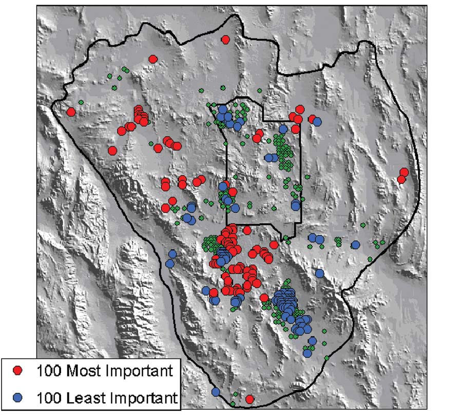
Figure 9. Rankings based on sensitivities of water-level observations and future forecasts of radionuclide transport paths to parameters of a regional model around Yucca Mountain, Nevada (modified from Hill and Tiedeman, in press).
Ground-water models are used frequently by water-resource managers to forecast the effects of stresses on water supplies and the movement of contaminants. Ground-water modeling tools are being used to incorporate procedures for calculating sensitivities to model parameters and uncertainties of model predictions.
Hydrologic modeling development over the next several years needs to be especially strong in several directions. Ground-water optimization models need to expand beyond applications of managing water-level declines to contaminant-plume containment, conjunctive ground-water and surface-water use, and saltwater-intrusion abatement.
Fully coupled ground-water and surface-water models need to be developed beyond the current prototypes to more fully developed, field-tested tools. Such integrated models will be in high demand for use in better understanding such processes as the rainfall-runoff response, ground-water level fluctuations near rivers, the effects of ground-water withdrawals on stream levels, and the contributions of ground water to streams. The newly coupled models also need to account for the transport and reactions of chemicals that are released at land surface, move into the subsurface, and discharge into streams. Use of new USGS models involving the coupling of surface-water, unsaturated-zone, and ground-water codes is expected at the watershed scale—that is, on the scale of 100 square kilometers (km2) or larger—where the issues of water supply and conjunctive use are addressed. The watershed scale is ideal for broadly integrating knowledge of how surface-water and ground-water interactions are affected under different scenarios of water-resources management.
Additionally, it is important that USGS research focuses on further development of coupled surface and subsurface models with a goal of increasing understanding of biogeochemical and ecological aspects of the interaction between surface water and ground water, and applying these models to water-quality, terrestrial, and aquatic ecological-resources management. Extension of watershed-scale models for fine-scale application to water-quality and ecological modeling needs to be addressed. An example of a fine-scale application is the development of coupled models that focus on reach-scale processes. Reach-scale models simulate solute and sediment transport processes in river corridors and the effects and interactions between subenvironments, such as hyporheic and riparian zones, on material transport, storage, and processing in the river corridor as a whole.
More widely field-tested 3–D variable-density flow models are needed. The intrusion of seawater into coastal aquifers has become an increasingly important issue as populations increase in coastal areas. The 3–D aspects of coastal aquifer systems can be significant, because pumping centers can produce cones of depression within a regional flow field that is perpendicular to the coastline. Computers continue to become more powerful, and 3–D codes that have been developed by the USGS (SUTRA3D, Voss and Provost, 2002; SEAWAT-2000, Guo and Langevin, 2002; Langevin and others, 2003) are just now being tested with data from real aquifer systems. Additional testing can produce a better understanding of the true capabilities and limitations of 3–D modeling codes under full regional-scale modeling situations.
Compatibility is needed between software packages that create input for ground-water models and those that create output from 3–D geologic models so that geologic information can be incorporated into the model quickly and efficiently. As we continue to develop and apply larger, more complex and more refined models to specific field sites, we will become more dependent on graphical user interfaces to process the input data sets necessary to adequately define the hydrogeologic system. A more realistic representation of a hydrologic boundary or geologic feature always requires detailed information to define the feature. Land-surface elevations, land-use and soil-type distributions, exact positions of rivers and lakes, and contacts between geologic units are examples of some of these features. Viewing the results in 3–D also is an essential requirement for analyzing results from 3–D models, and recent model-visualization software is proving to be greatly beneficial in interpreting model output. Animation of time-dependent output sequences also is needed. All of these graphical interface tools need to be made compatible with new and improved models as they are developed.
Studies are needed to define the types of additional data that can be incorporated, the types of hydrogeologic frameworks in which these data are most beneficial, and the best methods for including these data in the parameter-estimation process. Progress in model calibration over the next 10 years is promising because of the availability of new, universal, parameter-estimation software and the increasing speed and storage of computers at decreasing cost. No technical barriers exist to carry out such studies, but appropriate sites need to be identified and the resources obtained to gather the appropriate data. Two of the most promising types of data are from chemical tracers and geophysics. For example, environmental tracer data, such as ground-water age or travel path, provide direct information on the speed and direction of ground-water flow in the system. These tracer data are being used to help calibrate models and are beginning to be used in automatic calibration approaches.
Society needs models that not only can help forecast hydrologic events but also can estimate the uncertainty of these forecasts. Although nonlinear regression methods can give values for confidence intervals, the calculation of these intervals is based on the measurement error associated with observations, and such measurement errors are assumed to be greater than those associated with how the model represents the aquifer framework. As the error in the latter often is greater than in the former, new methods are needed that include the potential error in boundary locations or zonations in the statistical calculations that yield uncertainties. In addition to parameter uncertainties, there are uncertainties in the predictions themselves. Advancements appear promising in developing statistics that relate the prediction uncertainty to the individual parameter uncertainties. Further testing is needed to evaluate the credibility of such values of uncertainty assigned to model predictions.
Advances in the six ground-water science research topics described in this report could greatly improve our ability to forecast ground-water availability to sustain human use and support aquatic ecosystems. These topics do not cover all aspects of ground-water science that the USGS could pursue but were derived from interactions with colleagues internal and external to the USGS. The topics also are meant to foster discussion and continued evolution of research opportunities on which USGS scientists can focus in the coming years.
A major challenge for the USGS is to integrate the ground-water science summarized in these six topics with other USGS research that bears on understanding and forecasting ground-water sustainability. These topics and the science behind them are complex and highly technical, representing specialized research and expertise developed over many years. Integrating the science specializations and synthesizing the results of research to support decisionmaking for important societal issues pose important challenges to biologists, geographers, geologists, and hydrologists in the USGS.
A major goal of the USGS ground-water program is to provide a national and regional understanding of ground-water resources suitable for forecasting a sustainable level of human use and support to aquatic ecosystems. Underlying a national and regional understanding of ground-water sustainability is the need for the collection, compilation, and analysis of basic hydrologic, geologic, biologic, and geographic data. Therefore, it is critical to continue a commitment to monitoring and collecting long-term basic data at long-established sites and at new sites established to improve the science. This commitment will cultivate the growth of new programs that will incorporate lessons from the past while allowing for the flexibility to respond to the ever-changing needs of our growing population.
The research opportunities identified in this report for USGS ground-water science are summarized for each of the six topics as follows:
Mapping in Three Dimensions—Geology and Geophysics
Research and development are needed to bring 3–D capabilities to a level at which geologic models are routinely integrated with hydrologic models.
The ability to determine the relation of geophysical responses to hydraulic properties and the means to quantitatively incorporate this geophysical information and interpretation into hydrologic models are needed.
Improvements in geophysical methods that result from advancements in mathematical algorithms, visualization, and instrumentation are needed for ground-water studies.
Advancements in modeling capabilities, such as coupling 3–D seismic and other geophysical data and interpretation with hydraulic parameterization routines, are needed for ground-water models.
Characterizing Aquifer Heterogeneity
A better understanding of depositional environments and processes is needed to improve characterization of sedimentary aquifers.
Research that focuses on understanding the control that fault zones and other structures, such as folds, have on a ground-water flow system is needed.
Information synthesized from multiple aquifer- characterization methods is needed to develop a conceptual understanding of aquifer heterogeneity and its control on ground-water flow and contaminant movement.
Geologic controls on ground-water flow over increasingly larger dimensions needs to be investigated in different geologic settings, and methods of inferring hydraulic properties of bedrock with confidence needs to be developed over increasingly larger scales through a combination of geologic, geophysical, geochemical, and hydrologic methods.
A better understanding of the magnitude of the contaminant mass that is constrained within the intrinsic porosity of rocks (and bound to fracture surfaces) is needed, which could lead to more realistic approaches to ground-water remediation.
Additional emphasis needs to be given to more comprehensive and quantitative approaches for characterizing and predicting flow and transport in fractured-rock and karst terrains.
Measuring Recharge to Ground-Water Flow Systems
The USGS needs to build upon the results of research in meteorological and agricultural disciplines to improve recharge estimation.
Research is needed to understand better the various physical and chemical processes in the variably saturated zone.
Improved efficiency and capability of collecting and analyzing ground-water age tracer data is needed to improve estimates of recharge rates.
Stochastic approaches are needed to address the spatial variability in soil and rock types and the resulting variations in recharge rates.
The long-term hydraulic response of the aquifer system and the geochemical effects of mixing water of different chemistries need to be studied at pilot test sites and through numerical simulation.
Methodologies are needed to incorporate predictions of changes in rainfall and evapotranspiration made with global climate models into recharge calculations for ground-water models.
Quantifying Ground-Water and Surface-Water Interaction
The USGS needs to improve expertise in bridging soil-vegetation-atmospheric modeling with hydrologic modeling for a fuller understanding of the ground-water component of the hydrologic cycle.
Advancements in a variety of techniques to measure flux and identify discharge areas need to be applied to ground-water studies.
The focus of research in evapotranspiration needs to shift from making local measurements to obtaining average regional values.
Substantial research external to the USGS with regard to evapotranspiration derived from remote-sensing data needs to be coupled with USGS investigations to develop a comprehensive set of methods and approaches.
Rigorous research is needed for both the benefits and constraints of using remote sensing for determining evapotranspiration.
Understanding the Relation of Ground-Water Flow Systems to Aquatic Ecosystems
Mechanisms that foster collaboration among scientists from different disciplines are needed to ensure an integrated approach to ground-water and ecological studies in the USGS.
Research is needed to better understand the role of various hydrologic components at various scales in order to forecast changes in water budgets of local aquatic ecosystems affected by human activities.
Forecasting changes in the quality of water in aquatic ecosystems that are influenced directly by human activities is needed to understand better ground-water interactions.
More research is needed to determine the ability of wetland and riparian areas to improve surface-water quality.
Developing More Effective Computer Models
Ground-water optimization models need to expand beyond applications of managing water-level declines to contaminant-plume containment, conjunctive ground-water and surface-water use, and saltwater-intrusion abatement.
Fully coupled ground-water and surface-water models need to evolve beyond the current prototypes into fully developed, field-tested tools.
USGS research needs to focus on further development of coupled surface-subsurface models with a goal to increase understanding of biogeochemical and ecological aspects of the interaction between surface water and ground water.
3–D variable-density flow models need to be tested more widely in field settings. Compatibility is needed between software packages that create input to ground-water models and those that create input to 3–D geologic models.
Studies are needed to define the types of additional data that can be incorporated, the types of hydrogeologic frameworks and degree of heterogeneity in which these data are most beneficial, and the best methods for including these data in the parameter-estimation process.
Society needs models that not only can help forecast hydrologic events but also can estimate the uncertainty of these predictions.
Boulanger, R.W., and Duncan, J.M., 2000, Geotechnical Engineering Photo Album: University of California at Davis, accessed March 15, 2006, at http://cee.engr.ucdavis.edu/faculty/boulanger/geo_photo_album/.
Desmond, G.B., Jones, J.W., and Lemeshewsky, G.P., 1999, The South Florida land characterization project, in Gerould, S., and Higer, A., comps., U.S. Geological Survey program on the South Florida ecosystem—Proceedings of South Florida Restoration Science Forum, May 17–19, 1999, Boca Raton, Florida: U.S. Geological Survey Open-File Report 99–181, p. 14–15.
German, E.R., 2000, Regional evaluation of evapotranspiration in the Everglades: U.S. Geological Survey Water-Resources Investigations Report 00–4217, 48 p.
Guo, W., and Langevin, C.D., 2002, User’s guide to SEAWAT—A computer program for simulation of three-dimensional variable-density ground-water flow: U.S. Geological Survey Techniques of Water-Resources Investigations, book 6, chap. A7, 77 p.
Harbaugh, A.W., Banta, E.R., Hill, M.C., and McDonald, M.G., 2000, MODFLOW–2000, the U.S. Geological Survey modular ground-water model—User guide to modularization concepts and ground-water flow process: U.S. Geological Survey Open-File Report 00–92, 121 p.
Hill, M.C., Banta, E.R., Harbaugh, A.W., and Anderman, E.R., 2000, MODFLOW–2000, the U.S. Geological Survey modular ground-water model—User guide to the observation, sensitivity, and parameter-estimation processes and three post-processing programs: U.S. Geological Survey Open-File Report 00–184, 209 p.
Hill, M.C., and Tiedeman, C.R., in press, Effective ground-water model calibration, with analysis of sensitivities, predictions, and uncertainty: New York, John Wiley & Sons, Inc., 384 p.
Hyndman, D.W., Harris, J.M., and Gorelick, S.M., 2000, Inferring the relation between seismic slowness and hydraulic conductivity in heterogeneous aquifers: Water Resources Research, v. 36, no. 8, p. 2121–2132.
Laczniak, R.J., DeMeo, G.A., Reiner, S.R., Smith, J.L., and Nylund, W.E., 1999, Estimates of ground-water discharge as determined from measurements of evapotranspiration, Ash Meadows area, Nye County, Nevada: U.S. Geological Survey Water-Resources Investigations Report 99–4079, 70 p.
Langevin, C.D., 2001, Simulation of ground-water discharge to Biscayne Bay, Southeastern Florida: U.S. Geological Survey Water-Resources Investigations Report 00–4251, 127 p.
Langevin, C.D., Shoemaker, W.B., and Guo, W., 2003, MODFLOW–2000, the U.S. Geological Survey modular ground-water model—Documentation of the SEAWAT–2000 version with the variable-density flow process (VDF) and the integrated MT3DMS transport process (IMT): U.S. Geological Survey Open-File Report 03–426, 43 p.
Leavesley, G.H., Lichty, R.W., Troutman, B.M., and Saindon, L.G., 1983, Precipitation-runoff modeling system—User’s manual: U.S. Geological Survey Water-Resources Investigations Report 83–4238, 207 p.
National Aeronautics and Space Administration, Jet Propulsion Laboratory, California Institute of Technology, 2006, Advanced Spaceborne Thermal Emission and Reflection Radiometer (ASTER), accessed February 2003 at http://asterweb.jpl.nasa.gov/.
National Research Council, 2000, Investigating groundwater systems on regional and national scales: Washington, D.C., National Academy Press, 143 p.
National Research Council, 2001, Aquifer storage and recovery in the comprehensive Everglades restoration plan—A critique of the pilot projects and related plans for ASR in the Lake Okeechobee and Western Hillsboro areas: Washington, D.C., National Academy Press, 58 p.
Nichols, W.D., 2000, Regional ground-water evapotranspiration and ground-water budgets, Great Basin, Nevada: U.S. Geological Survey Professional Paper 1628.
Poeter, E.P., and Hill, M.C., 1998, Documentation of UCODE, a computer code for universal inverse modeling: U.S. Geological Survey Water-Resources Investigations Report 98–4080, 116 p.
Potter, C.J., Day, W.C., Sweetkind, D.S., and Dickerson, R.P., 2004, Structural geology of the proposed site area for a high-level radioactive waste repository, Yucca Mountain, Nevada: Geological Society of America Bulletin, v. 116, p. 858–879.
Sucksdorff, Y., and Ottle, C., 1990, Application of satellite remote sensing to estimate areal evapotranspiration over a watershed: Journal of Hydrology, v. 121, p. 321–333.
Voss, C.I., and Provost, A.M., 2002, SUTRA—A model for saturated-unsaturated variable-density ground-water flow with solute or energy transport: U.S. Geological Survey Water-Resources Investigations Report 02–4231, 260 p.
Winter, T.C., Harvey, J.W., Franke, O.L., and Alley, W.M., 1998, Ground water and surface water—a single resource: U.S. Geological Survey Circular 1139, 79 p.
| AccessibilityFOIAPrivacyPolicies and Notices | |
 |
|