Data Series 839

This Data Series Report contains lidar elevation data collected from September 5 to October 11, 2012, for the barrier islands of Alabama, Mississippi and southeast Louisiana, including the coast near Port Fourchon. Most of the data were collected September 5–10, 2012, with a reflight conducted on October 11, 2012, to increase point density in some areas. Point cloud data—data points described in three dimensions—in lidar data exchange format (LAS), and bare earth digital elevation models (DEMs) in ERDAS Imagine raster format (IMG), are available as downloadable files. The point cloud data were processed to extract bare earth data; therefore, the point cloud data are organized into four classes: 1-unclassified, 2-ground, 7-noise and 9-water. Aero-Metric, Inc., was contracted by the U.S. Geological Survey (USGS) to collect and process these data.
The lidar data were acquired at a horizontal spacing (or nominal pulse spacing) of 1 meter (m) or less. The USGS conducted two ground surveys in a small area on Chandeleur Island on September 6, 2012, one on bare earth and the other in both bare earth and vegetated areas. The USGS calculated a vertical root mean square error (RMSEz) of 0.072 m and an offset of 0.007 m using interpolated 2-m by 2-m resolution grid surfaces made from the lidar bare-earth data and the combined USGS ground surveys. Aero-Metric, Inc., calculated an RMSEz of 0.025 m by comparing the USGS bare earth ground survey point data to the closest lidar points. The USGS also conducted a terrestrial lidar survey on Dauphin Island, Louisiana, on September 3, 2012. The USGS calculated a RMSEz of 0.32 m and an offset of 0.27 m, meaning the lidar data were 0.27 m higher than the ground truth (Guy and others, 2013), using interpolated 2-m by 2-m resolution grid surfaces from the airborne lidar bare-earth data and the terrestrial lidar survey.
This lidar survey was acquired to document the changes of several different barrier island systems resulting from Hurricane Isaac (Guy and others, 2013). The survey supports detailed studies of Louisiana, Mississippi and Alabama barrier islands that resolve annual and episodic changes in beaches, berms and dunes associated with processes driven by storms, sea-level rise, and even human restoration activities.
These lidar data are available to Federal, State and local governments, emergency-response officials, resource managers, and the general public.
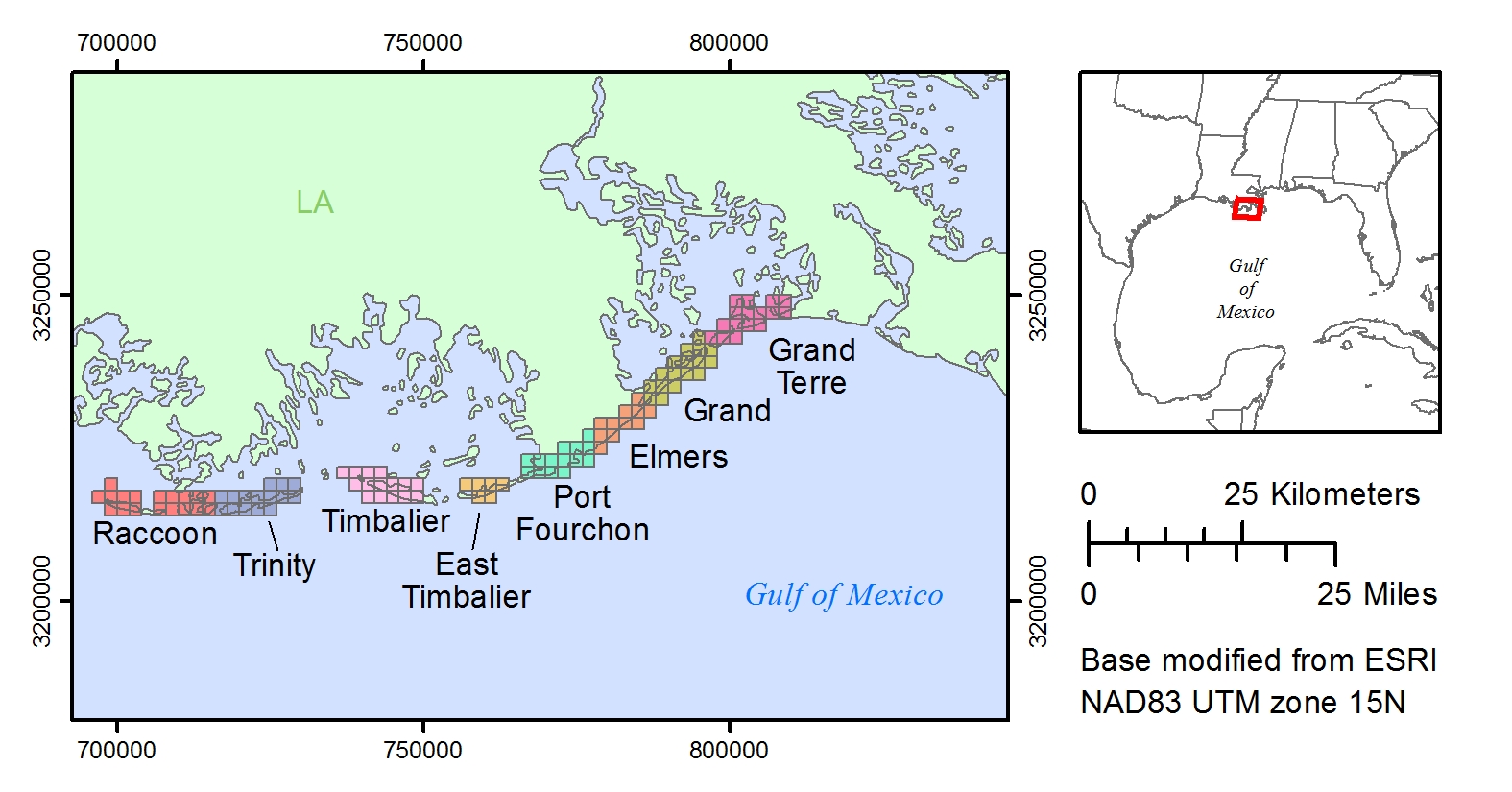
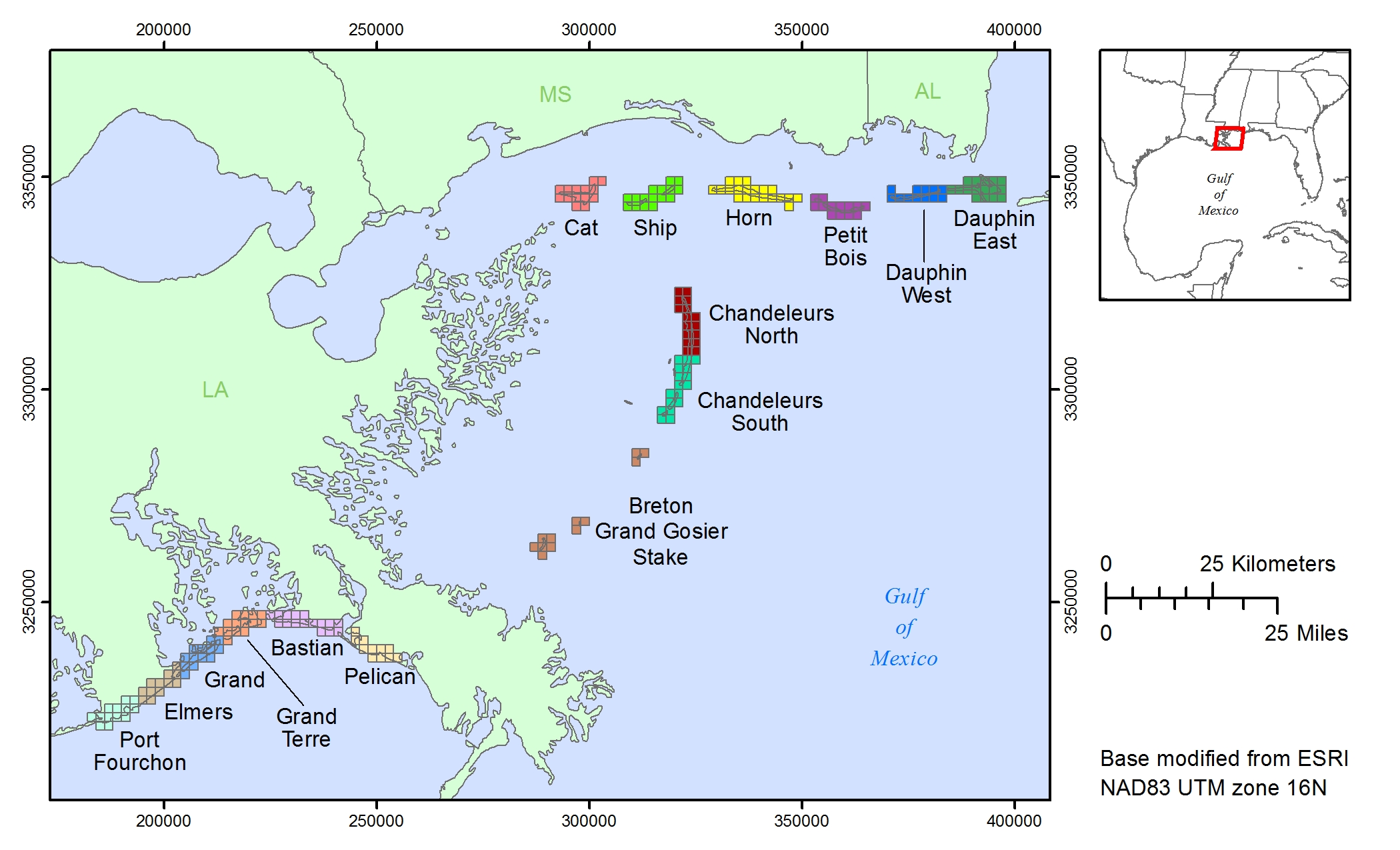
The bare earth DEMs and classified LAS files are organized into 2 kilometer (km) square areas called tiles. The Tile Index shapefiles and maps locate the tiles by their filename.
The DEM and LAS metadata files apply to all the tiles.
The bare earth DEM and classified LAS tiles can be downloaded by region or individually from file directories. The DEM files are 32-bit floating point, 1-meter (m) horizontal resolution IMG files. The LAS files are version 1.2. Both the DEM and LAS files are in meters, North American Datum 1983, Universal Transverse Mercator zone 15 North or 16 North, North American Vertical Datum 1988, geoid 2012 (NAD83, UTM zone 15N or 16N, NAVD88, GEOID12a). The data near the border of UTM zones 15 and 16 (Port Fourchon, Elmers, Grand and Grand Terre regions in Louisiana) have been projected into both zones for convenience. Vertical datum transformation can be made using VDatum. LAZ files (LASzipped LAS files) can be unzipped using LASzip.
| DEM tiles by region | LAS tiles by region |
|---|---|
| Louisiana | |
|
Raccoon (33 MB) Trinity (39 MB) Timbalier (37 MB) East Timbalier (10 MB) Port Fourchon (38 MB) Elmers (20 MB) Grand (40 MB) Grand Terre (37 MB) |
Raccoon (360 MB) Trinity (460 MB) Timbalier (385 MB) East Timbalier (88 MB) Port Fourchon (426 MB) Elmers (200 MB) Grand (459 MB) Grand Terre (388 MB) |
| DEM tiles by region | LAS tiles by region |
|---|---|
| Louisiana | |
|
Port Fourchon (37 MB) Elmers (24 MB) Grand (36 MB) Grand Terre (33 MB) Bastian (27 MB) Pelican (24 MB) Breton, Grand Gosier, Stake (12 MB) Chandeleurs South (36 MB) Chandeleurs North (40 MB) |
Port Fourchon (419 MB) Elmers (243 MB) Grand (422 MB) Grand Terre (350 MB) Bastian (346 MB) Pelican (231 MB) Breton, Grand Gosier, Stake (333 MB) Chandeleurs South (358 MB) Chandeleurs North (358 MB) |
| Mississippi | |
|
Cat (36 MB) Ship (29 MB) Horn (57 MB) Petit Bois (29 MB) |
Cat (397 MB) Ship (289 MB) Horn (553 MB) Petit Bois (282 MB) |
| Alabama | |
|
Dauphin West (26 MB) Dauphin East (38 MB) |
Dauphin West (256 MB) Dauphin East (471 MB) |
| DEM individual tile directories | LAZ individual tile directories |
|---|---|
| Louisiana | |
|
Raccoon Trinity Timbalier East Timbalier Port Fourchon Elmers Grand Grand Terre |
Raccoon Trinity Timbalier East Timbalier Port Fourchon Elmers Grand Grand Terre |
| DEM individual tile directories | LAZ individual tile directories |
|---|---|
| Louisiana | |
|
Port Fourchon Elmers Grand Grand Terre Bastian Pelican Breton, Grand Gosier, Stake Chandeleurs South Chandeleurs North |
Port Fourchon Elmers Grand Grand Terre Bastian Pelican Breton, Grand Gosier, Stake Chandeleurs South Chandeleurs North |
| Mississippi | |
|
Cat Ship Horn Petit Bois |
Cat Ship Horn Petit Bois |
| Alabama | |
|
Dauphin West Dauphin East |
Dauphin West Dauphin East |
The USGS National Assessment of Coastal Change Hazards Project thanks Emily Klipp from the USGS St. Petersburg Coastal and Marine Science Center (SPCMSC) for planning and data management; Mark Hansen, B.J. Reynolds, Nancy Dewitt, and Kyle Kelso (SPCMSC) for conducting the Chandeleur Islands ground survey; Dustin Kimbrow, Athena Clark from the USGS Alabama Water Science Center, and Justin T. Minear from the USGS California Water Science Center for providing terrestrial lidar control data at Dauphin Island; James Young and others at Aero-Metric, Inc. for data acquisition and post-processing; James M. Duncan and Timothy W. Saultz from the USGS National Geospatial Technical Operations Center for lidar contracting; Felipe Dones-Cardona and Patti Hartsing (SPCMSC) for administrative support with lidar contracting.
Guy, K.K., Stockdon, H.F., Plant, N.G., Doran, K.J., and Morgan, K.L.M, 2013, Hurricane Isaac—Observations and analysis of coastal change: U.S. Geological Survey Open-File Report 2013–1270, 21 p., accessed January 27, 2014, at https://dx.doi.org/10.3133/ofr20131270.
Guy, K.K., Doran, K.J., Stockdon, H.F., and Plant, N.G., 2014, Topographic Lidar Survey of the Alabama, Mississippi, and Southeast Louisiana Barrier Islands, from September 5 to October 11, 2012: U.S. Geological Survey Data Series 839, 1 p., https://dx.doi.org/10.3133/ds839.
ISSN 2327-638X (online)

![]() U.S. Department of the Interior |
U.S. Geological Survey
U.S. Department of the Interior |
U.S. Geological Survey
URL: http://pubsdata.usgs.gov/pubs/ds/0839/ds839title.html
Page Contact Information: GS Pubs Web Contact
Page Last Modified: Monday, 28-Nov-2016 19:29:04 EST
