Skip Links

USGS - science for a changing world

Data Series 888


LIDAR Illustration

Index Link

Home Link

Purpose Link

Metadata Link

Collaborators Link

Acronyms Link

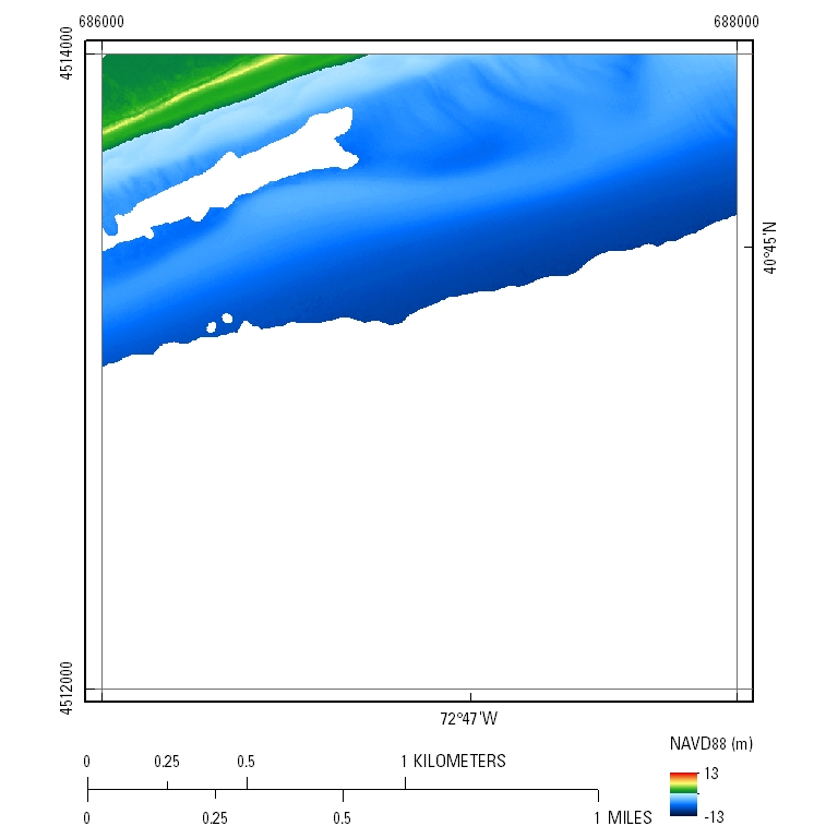
EAARL-B Coastal Topography—Fire Island, New York, Pre-Hurricane Sandy, 2012: Seamless (Bare Earth and Submerged)


UTM Tile e686_n4514_18

Pre-Hurricane Sandy: 2.5-meter resolution

Pre-Sandy Seamless Topography

  • Link To Tile Directory
    Click the link above to access the GeoTIFF, LAS, and XYZ data organized in 2-km by 2-km tiles.
  • GeoTIFF DEM .tif File
    PLEASE NOTE: GeoTIFF files can only be viewed using software capable of reading georeferenced 32-bit floating point format imagery, such as Global Mapper, GRASS, or Esri ArcMap.

Accessibility FOIA Privacy Policies and Notices

Take Pride in America logo USA.gov logo U.S. Department of the Interior | U.S. Geological Survey
URL: http://pubsdata.usgs.gov/pubs/ds/0888/html/tile_htmls/e686_n4514_18.html
Page Contact Information: GS Pubs Web Contact
Page Last Modified: Monday, 28-Nov-2016 20:29:41 EST