Data Series 906
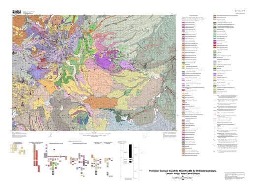
AbstractThe Mount Hood 30- by 60-minute quadrangle covers the axis and east flank of the Cascade Range in northern Oregon. Its namesake, Mount Hood volcano, dominates the view in the northwest quarter of the quadrangle, but the entire area is underlain by Oligocene and younger volcanic and volcaniclastic rocks of the Cascade Range. Since the time of the Columbia River Basalt Group about 15 million years (m.y.) ago, the locus and composition of Cascade Range volcanism have shifted sporadically across the map area. Andesitic eruptions were predominant in the western part from about 14 to 10 m.y. ago (Salmon and Sandy Rivers area), producing the Rhododendron Formation and overlying lava flows. From about 8 to 6.5 m.y. ago, lithic pyroclastic debris of the Dalles Formation was shed by chiefly andesitic volcanoes in the north-central part of the map area (Hood River valley escarpment). Andesitic to dacitic volcanism was again predominant about 5 to 3 m.y. ago, with known eruptive centers located from Lookout Mountain westward to Lolo Pass, probably including the area now occupied by Mount Hood. A major episode of mafic volcanism—basalt and basaltic andesite—began about 3–4 m.y. ago and lasted until about 2 m.y. ago. Volcanism since about 2 m.y. ago has been concentrated along the axis of the High Cascades. North and south of Mount Hood these youngest rocks are predominantly basaltic andesite lava flows; whereas at Mount Hood itself, andesite is predominant, forming pyroclastic and debris-flow deposits and lava flows. This geodatabase contains information derived from legacy mapping that was published in 1995 as U.S. Geological Survey Open-File Report 95-219. The main component of this publication is a geologic map database prepared using geographic information system (GIS) applications. Included are pdf files to view or print the map sheet, the accompanying pamphlet from Open-File Report 95-219, and links to the original publication, which is available as scanned files in pdf format. |
First posted December 23, 2014
For additional information, contact: Part or all of this report is presented in Portable Document Format (PDF). For best results viewing and printing PDF documents, it is recommended that you download the documents to your computer and open them with Adobe Reader. PDF documents opened from your browser may not display or print as intended. Download the latest version of Adobe Reader, free of charge. More information about viewing, downloading, and printing report files can be found here. Part of this report is presented in Microsoft Excel format (XLSX); the latest version of Excel Viewer is required to view it. Download the latest version of Excel Viewer, free of charge. |
Ma, Lina, Sherrod, D.R., and Scott, W.E., 2014, Digital data for preliminary geologic map of the Mount Hood 30- by 60-minute quadrangle, northern Cascade Range, Oregon: U.S. Geological Survey Data Series 906, pamphlet 36 p., scale 1:100,000, https://dx.doi.org/10.3133/ds906.

![]() U.S. Department of the Interior |
U.S. Geological Survey
U.S. Department of the Interior |
U.S. Geological Survey
URL: http://pubsdata.usgs.gov/pubs/ds/0906/index.html
Page Contact Information: GS Pubs Web Contact
Page Last Modified: Monday, 28-Nov-2016 20:31:17 EST
