Skip Links

USGS - science for a changing world

Data Series 913

LIDAR Illustration

Index Link

Home Link

Project Description

Metadata Link

Collaborators Link

Acronyms Link

EAARL-B Coastal Topography—Chandeleur Islands, Louisiana, 2012: Seamless (Bare Earth and Submerged)

C. Wayne Wright,1 Emily S. Klipp,2 Christine J. Kranenburg,2 Rodolfo J. Troche,1 Xan Fredericks,2 Melanie L. Masessa,2 and David B. Nagle1

1U.S. Geological Survey; 2Cherokee Nation Technology Solutions, St. Petersburg, Florida.


This data series report contains lidar-derived seamless (bare-earth and submerged) topography Geographic Information System (GIS) datasets acquired on August 7 and 8, 2012, for a portion of the Chandeleur Islands, Louisiana.

Click on a tile number (1 - 52) to view the corresponding images and links to each data directory.


UTM Map of the Chandeleur Islands Tile e314_n3292_16Tile e316_n3292_16Tile e314_n3294_16Tile e316_n3294_16Tile e318_n3294_16Tile e316_n3296_16Tile e318_n3296_16Tile e316_n3298_16Tile e318_n3298_16Tile e320_n3298_16Tile e318_n3300_16Tile e320_n3300_16Tile e318_n3302_16Tile e320_n3302_16Tile e322_n3302_16Tile e322_n3304_16Tile e320_n3304_16Tile e322_n3306_16Tile e320_n3306_16Tile e324_n3308_16Tile e322_n3308_16Tile e320_n3308_16Tile e324_n3310_16Tile e322_n3310_16Tile e320_n3310_16Tile e324_n3312_16Tile e322_n3312_16Tile e320_n3312_16Tile e324_n3314_16Tile e322_n3314_16Tile e320_n3314_16Tile e324_n3316_16Tile e322_n3316_16Tile e320_n3316_16Tile e324_n3318_16Tile e322_n3318_16Tile e320_n3318_16Tile e324_n3320_16Tile e322_n3320_16Tile e320_n3320_16Tile e318_n3320_16Tile e322_n3322_16Tile e320_n3322_16Tile e318_n3322_16Tile e322_n3324_16Tile e320_n3324_16Tile e318_n3324_16Tile e322_n3326_16Tile e320_n3326_16Tile e318_n3326_16Tile e320_n3328_16Tile e318_n3328_16


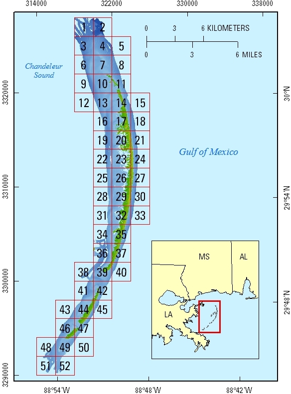
Click on the link below to access the shapefile directory of the 2-km by 2-km tile extents displayed above.

Shapefile of Tile Extents


Suggested Citation:

Wright, C.W., Klipp, E.S., Kranenburg, C.J., Troche, R.J., Fredericks, Xan, Masessa, M.L., and Nagle, D.B., 2015, EAARL-B coastal topography–Chandeleur Islands, Louisiana, 2012—Seamless (bare earth and submerged): U.S. Geological Survey Data Series 913, https://dx.doi.org/10.3133/ds913.

Accessibility FOIA Privacy Policies and Notices

Take Pride in America logo USA.gov logo U.S. Department of the Interior | U.S. Geological Survey
URL: http://pubsdata.usgs.gov/pubs/ds/0913/html/ds_home.html
Page Contact Information: GS Pubs Web Contact
Page Last Modified: Monday, 28-Nov-2016 20:32:31 EST