Skip Links

USGS - science for a changing world

Data Series 945

Post-Hurricane Ivan Coastal Oblique Aerial Photographs Collected from Crawfordville, Florida, to Petit Bois Island, Mississippi, September 17, 2004

By Karen L.M. Morgan, M. Dennis Krohn, Russell Peterson, Phillip R. Thompson, and Janice Subino

Thumbnail of and link to reportSummary

The U.S. Geological Survey (USGS) conducts baseline and storm response photography missions to document and understand the changes in vulnerability of the Nation's coasts to extreme storms. On September 17, 2004, the USGS conducted an oblique aerial photographic survey from Crawfordville, Florida, to Petit Bois Island, Mississippi aboard a Piper Navajo Chieftain (aircraft) at an altitude of 500 feet (ft) and approximately 1,000 ft offshore. This mission was flown to collect post-Hurricane Ivan data for assessing incremental changes in the beach and nearshore area since the last survey in 2001, and the data can be used in the assessment of future coastal change.

The images provided in this report are Joint Photographic Experts Group (JPEG) images. ExifTool was used to add the following to the header of each photo: time of collection, Global Positioning System (GPS) latitude, GPS longitude, keywords, credit, artist (photographer), caption, copyright, and contact information. The photograph locations are an estimate of the position of the aircraft and do not indicate the location of any feature in the images. These photographs document the state of the barrier islands and other coastal features at the time of the survey. Pages containing thumbnail images of the photographs, referred to as contact sheets, were created in 5-minute segments of flight time. These segments can be found on the Photos and Maps page. The photographs can be opened directly with any JPEG-compatible image viewer by clicking on a thumbnail on the contact sheet.

Table 1 provides detailed information about the GPS location, image name, date, and time for each of the 3,381 photographs taken, along with links to each photograph. The photographs are organized into segments, also referred to as contact sheets, and represent approximately 5 minutes of flight time. In addition to the photographs, a Google Earth Keyhole Markup Language (KML) file is provided, which can be used to view the images by clicking on the marker and then clicking on either the thumbnail or the link above the thumbnail. The KML files were created using the photographic navigation files.

First posted July 20, 2015

For additional information, contact:
Director, St. Petersburg Coastal and Marine Science Center
U.S. Geological Survey
600 Fourth Street South
St. Petersburg, FL 33701–4846
(727) 502–8000
http://coastal.er.usgs.gov/

Part or all of this report is presented in Portable Document Format (PDF). For best results viewing and printing PDF documents, it is recommended that you download the documents to your computer and open them with Adobe Reader. PDF documents opened from your browser may not display or print as intended. Download the latest version of Adobe Reader, free of charge. More information about viewing, downloading, and printing report files can be found here.


Suggested citation:

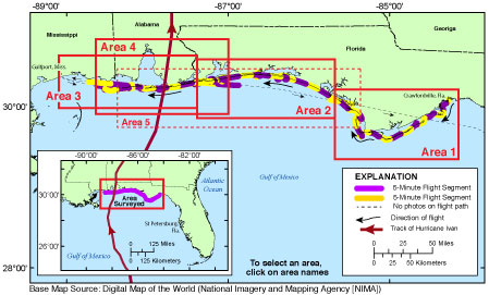
Morgan, K.L.M., Krohn, M.D., Peterson, R., Thompson, P.R., and Subino, J.A., 2015, Post-Hurricane Ivan coastal oblique aerial photographs collected from Crawfordville, Florida, to Petit Bois Island, Mississippi, September 17, 2004: U.S. Geological Survey Data Series 945, https://dx.doi.org/10.3133/ds945.

ISSN 2327-638X (online)


Contents

Project Summary

Getting Started

Report Organization

List of Figures

Reference Cited

Suggested Citation

Acknowledgments

Information Statement

System Requirements

Contact


Accessibility FOIA Privacy Policies and Notices

Take Pride in America logo USA.gov logo U.S. Department of the Interior | U.S. Geological Survey
URL: http://pubsdata.usgs.gov/pubs/ds/0945/index.html
Page Contact Information: GS Pubs Web Contact
Page Last Modified: Monday, 28-Nov-2016 20:37:49 EST