Data Series 946
The maps below show the division of the flights into areas and the flight path into 5-minute (time) segments. The areas and segments are organized by date and time of flight, generally proceeding from north to south with the exception of opportunistic photos (Area 11) taken from south to north on day four during the return to Falmouth Airpark in Falmouth, Massachusetts. Each segment is represented by alternating purple and yellow lines. Pages containing thumbnail images of the photographs, referred to as contact sheets, were created based on these segments. Click on each segment name to access the respective contact sheet. Five of the areas (1, 3, 7, 8, and 9) have inset maps, shown by red boxes in figures 3A, 3C, 3G, 3H, and 3I, to better show the complex flight paths in those subareas. Refer to Table 1 for a list of images, latitude and longitude, and date and time by contact sheet.
Each segment, which has a corresponding contact sheet, is labeled with the following format: yyyy_mmdd_hhmmss, where yyyy denotes the year, mmdd denotes the month and day, and hhmmss denotes the start of the 5-minute segment of time during which those photographs were taken. For example, image 2009_0519_164000 was taken May 19, 2009, starting at 16:40:00 CoordinatedUniversal Time (UTC). All times refer to UTC. Best effort was made to set the camera's internal clock to within 1 second of UTC at the beginning of the flight. Three cameras were used during this flight. The main camera, a Nikon D1X, is designated with a "d" after the hhmmss in the filename. This camera took continuous imagery along the coast. The additional cameras collected imagery whenever an opportunity presented itself. "d2" designated images taken with a Canon EOS 20D, and "d3" designates images taken with a Pentax K100D.
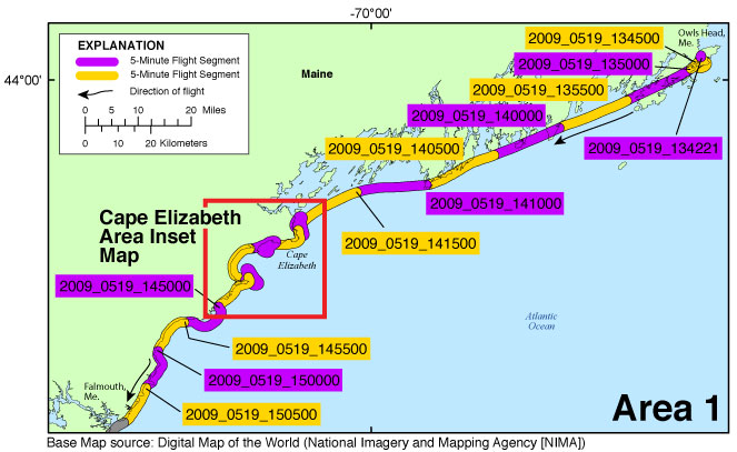
Figure 3A. Area 1 - Owls, Maine, Head to Portland, Maine. Map showing the baseline coastal oblique aerial survey flight path divided into 5-minute (time) segments. The flight path is represented by the alternating purple and yellow lines. Pages containing thumbnail images of the photographs, referred to as contact sheets, were created based on these segments. Click on the five-minute segment name to view each contact sheet. Click on the inset box to view a detailed map of the area. |
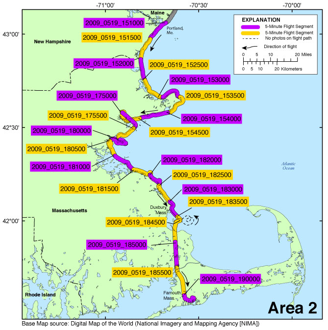
Figure 3B. Area 2 - Portland, Maine to Humarock, Massachusetts, continuing on to Falmouth Airpark. Map showing the baseline coastal oblique aerial survey flight path divided into 5-minute (time) segments. The flight path is represented by the alternating purple and yellow lines. Pages containing thumbnail images of the photographs, referred to as contact sheets, were created based on these segments. Click on the five-minute segment name to view each contact sheet. |
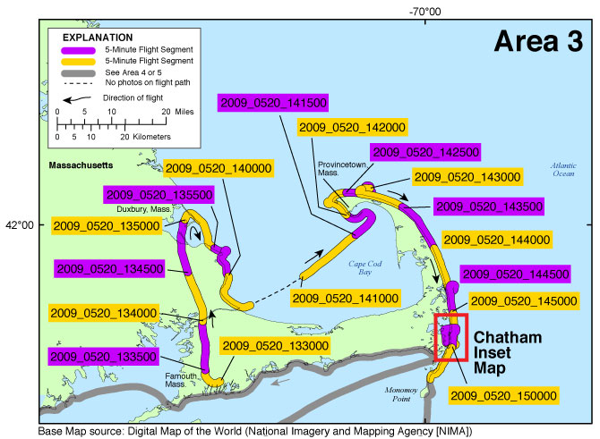
Figure 3C. Area 3 - Humarock, Massachusetts, to the Cape Cod Canal, then from Provincetown to Monomoy National Wildlife Refuge, Massachusetts. Map showing the baseline coastal oblique aerial survey flight path divided into 5-minute (time) segments. The flight path is represented by the alternating purple and yellow lines. Pages containing thumbnail images of the photographs, referred to as contact sheets, were created based on these segments. Click on the five-minute segment name to view each contact sheet. Click on the inset box to view a detailed map of the area. |
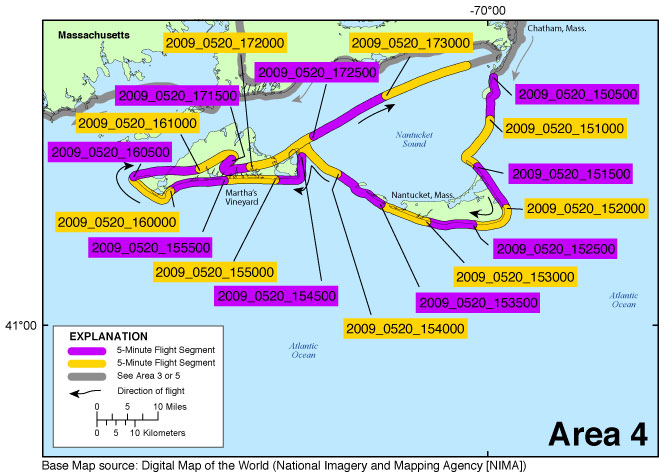
Figure 3D. Area 4 - Monomoy National Wildlife Refuge to Nantucket, Martha’s Vineyard, and back to Chatham, Massachusetts. Map showing the baseline coastal oblique aerial survey flight path divided into 5-minute (time) segments. The flight path is represented by the alternating purple and yellow lines. Pages containing thumbnail images of the photographs, referred to as contact sheets, were created based on these segments. Click on the five-minute segment name to view each contact sheet. |
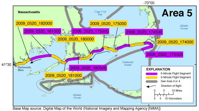
Figure 3E. Area 5 - Nantucket Sound coastline of Cape Cod to South Dartmouth, Massachusetts. Map showing the baseline coastal oblique aerial survey flight path divided into 5-minute (time) segments. The flight path is represented by the alternating purple and yellow lines. Pages containing thumbnail images of the photographs, referred to as contact sheets, were created based on these segments. Click on the five-minute segment name to view each contact sheet. |
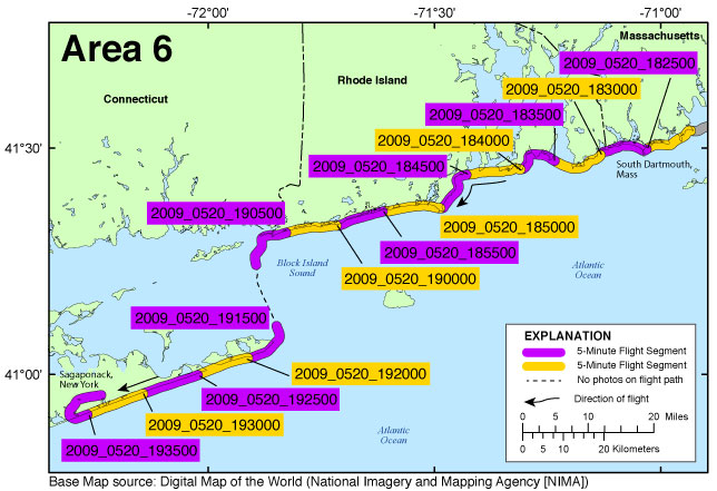
Figure 3F. Area 6 - South Dartmouth, Massachusetts, to Sagaponack, New York. Map showing the baseline coastal oblique aerial survey flight path divided into 5-minute (time) segments. The flight path is represented by the alternating purple and yellow lines. Pages containing thumbnail images of the photographs, referred to as contact sheets, were created based on these segments. Click on the five-minute segment name to view each contact sheet. |
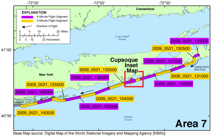
Figure 3G. Area 7 - Sagaponack to Point Lookout, New York. Map showing the baseline coastal oblique aerial survey flight path divided into 5-minute (time) segments. The flight path is represented by the alternating purple and yellow lines. Pages containing thumbnail images of the photographs, referred to as contact sheets, were created based on these segments. Click on the five-minute segment name to view each contact sheet. Click on the inset box to view a detailed map of the area. |
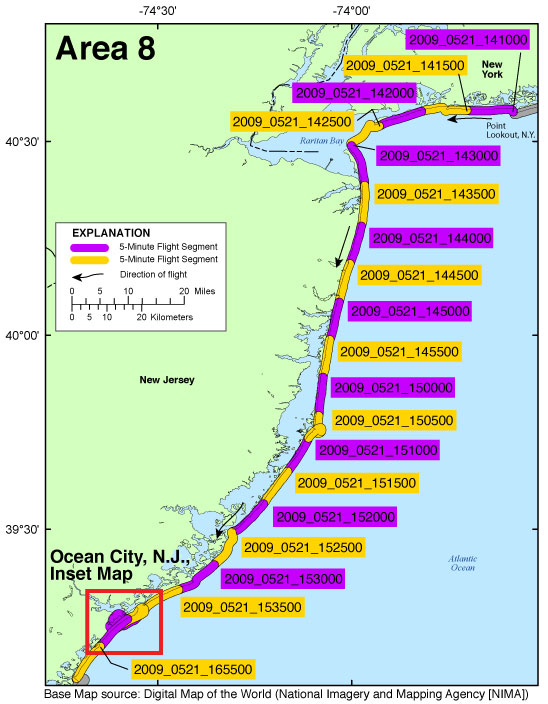
Figure 3H. Area 8 - Point Lookout, New York, to Ocean City, New Jersey. Map showing the baseline coastal oblique aerial survey flight path divided into 5-minute (time) segments. The flight path is represented by the alternating purple and yellow lines. Pages containing thumbnail images of the photographs, referred to as contact sheets, were created based on these segments. Click on the five-minute segment name to view each contact sheet. Click on the inset box to view a detailed map of the area. |
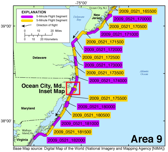
Figure 3I. Area 9 - Ocean City, New Jersey, to Wallops Island, Virginia. Map showing the baseline coastal oblique aerial survey flight path divided into 5-minute (time) segments. The flight path is represented by the alternating purple and yellow lines. Pages containing thumbnail images of the photographs, referred to as contact sheets, were created based on these segments. Click on the five-minute segment name to view each contact sheet. Click on the inset box to view a detailed map of the area. |
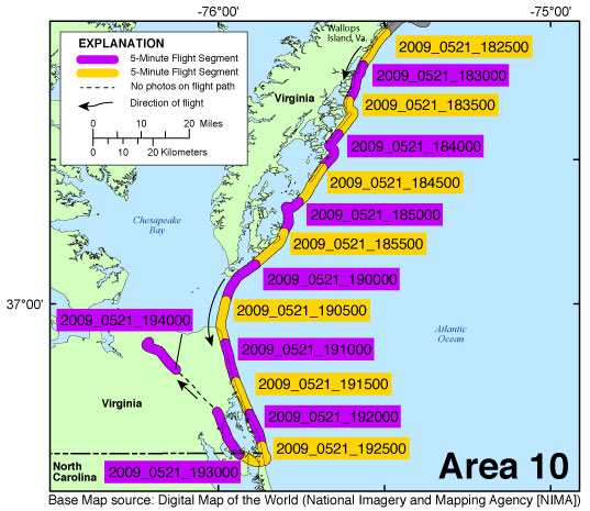
Figure 3J. Area 10 - Wallops Island, Virginia, to the Virginia/North Carolina boarder. Map showing the baseline coastal oblique aerial survey flight path divided into 5-minute (time) segments. The flight path is represented by the alternating purple and yellow lines. Pages containing thumbnail images of the photographs, referred to as contact sheets, were created based on these segments. Click on the five-minute segment name to view each contact sheet. |
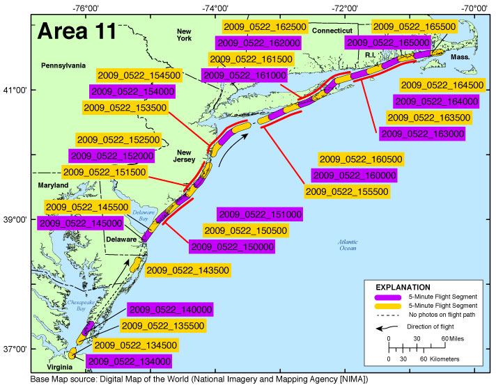
Figure 3K. Area 11 - Norfolk Airport, Virginia, to Falmouth Airpark, Massachusetts. Map showing the baseline coastal oblique aerial survey flight path divided into 5-minute (time) segments. The flight path is represented by the alternating purple and yellow lines. Pages containing thumbnail images of the photographs, referred to as contact sheets, were created based on these segments. Click on the five-minute segment name to view each contact sheet. |
Cape Elizabeth Area Inset Map | Chatham Inset Map | Cupsoque Inset Map | Ocean City, New Jersey, Inset Map | Ocean City, Maryland, Inset Map

![]() U.S. Department of the Interior |
U.S. Geological Survey
U.S. Department of the Interior |
U.S. Geological Survey
URL: http://pubsdata.usgs.gov/pubs/ds/0946/html/ds946_photos.html
Page Contact Information: GS Pubs Web Contact
Page Last Modified: Monday, 28-Nov-2016 20:37:57 EST
