Data Series 979
| Thriteen cross-shore profiles were flown in this location to allow documentation of two barrier island breaches. One breach occured at the Pea Island National Wildlife Refuge (NWR) ranger station (denoted with an *) and the other was at the north end of Rodanthe, North Carolina. The complex flight path at this location has been broken into four insets, A, B, C, and D, chronologically. The four insets break the flight into more visibly understandable time sections and allow the user to see the complex flight path. The purple and yellow colored lines correspond to 5-minute flight segments delineate the flight path in each inset, and the dashed gray line illustrates the rest of the flight path shown in other insets in this figure. Small numbers located near the arrows help the user follow the flight path along its course. |
Click on a segment name to view the contact sheet.
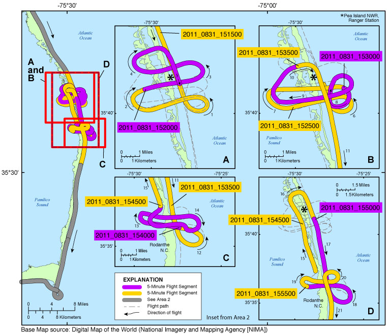
| Figure 5. Rodanthe and Pea Island NWR inset map (Area 2, fig. 3B). Map showing the flight path of the post-Hurricane Irene coastal oblique aerial survey from the ranger station in the Pea Island National Wildlife Refuge, North Carolina, to Rodanthe, North Carolina, on August 31, 2011. Purple and yellow lines correspond to 5-minute flight segments that link to contact sheets of associated photo thumbnails. Click on the 5-minute segment name to view each contact sheet. |

![]() U.S. Department of the Interior |
U.S. Geological Survey
U.S. Department of the Interior |
U.S. Geological Survey
URL: http://pubsdata.usgs.gov/pubs/ds/0979/html/ds979_inset05_rodanthepeaisl.html
Page Contact Information: GS Pubs Web Contact
Page Last Modified: Monday, 28-Nov-2016 20:44:26 EST
