Data Series 147

FGDC Metadata

Home | Acronyms | Contents | Navigation | Profiles | Logs | Metadata | Software


Identification_Information:
Citation:
Citation_Information:
Originator: Karynna Calderon
Originator: Shawn V. Dadisman
Originator: Jack L. Kindinger
Originator: James G. Flocks
Originator: Dana S. Wiese
Publication_Date: 2005
Title:
Archive of Digital Boomer Seismic Reflection Data Collected During USGS Cruise 94CCT02, South-Central South Carolina Coastal Region, August 1994
Geospatial_Data_Presentation_Form: Seismic Reflection Profile Section
Series_Information:
Series_Name: U.S. Geological Survey Data Series
Issue_Identification: 147
Publication_Information:
Publication_Place: St. Petersburg, FL
Publisher: U.S. Geological Survey
Description:
Abstract:
In August of 1994, the U.S. Geological Survey, in cooperation with Coastal Carolina University, conducted marine geophysical surveys in numerous water bodies adjacent to the south-central South Carolina coastal region. Data were collected aboard the MS Coastal in the Ashley, North Edisto, Wadmalaw, Dawho, South Edisto, and Ashepoo Rivers; the Wappoo, North, Steamboat, Bohicket, and Toogoodoo Creeks; Charleston Harbor; Wadmalaw Sound; Fenwick Cut; and the Atlantic Ocean from offshore Isle of Palms to Kiawah Island. This report serves as an archive of unprocessed digital boomer seismic reflection data, trackline maps, navigation files, GIS information, observers' logbooks, Field Activity Collection System (FACS) logs, and FGDC metadata. Filtered and gained digital images of the seismic profiles are also provided.

The archived trace data are in standard Society of Exploration Geophysicists (SEG) SEG-Y format (Barry and others, 1975) and may be downloaded and processed with commercial or public domain software such as Seismic Unix (SU). Example SU processing scripts and USGS software for viewing the SEG-Y files (Zihlman, 1992) are also provided.

Purpose:
The data archived here were collected in cooperation with Coastal Carolina University as part of the USGS Coastal Change and Transport (CCT) Project.
Supplemental_Information:
The USGS Florida Integrated Science Center (FISC) - Coastal and Watershed Studies in St. Petersburg, Florida, assigns a unique identifier to each cruise or field activity. For example, 94CCT02 tells us the data were collected in 1994 for the Coastal Change and Transport (CCT) Project and the data were collected during the second field activity for that project in that calendar year. Refer to <http://walrus.wr.usgs.gov/infobank/programs/html/definition/activity.html> for a detailed description of the method used to assign the cruise ID.

The boomer is an acoustic energy source that consists of capacitors charged to a high voltage and discharged through a transducer in the water. The transducer is towed on a sled at the sea surface and when discharged emits a short acoustic pulse, or shot, that propagates through the water and sediment column. The acoustic energy is reflected at density boundaries (such as the seafloor or sediment layers beneath the seafloor), detected by a receiver, and recorded by a PC-based seismic acquisition system. This process is repeated at timed intervals (e.g., 0.25 s) and recorded for specific intervals of time (e.g., 125 ms). In this way, a two-dimensional vertical image of the shallow geologic structure beneath the ship track is produced.

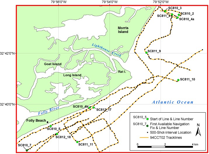
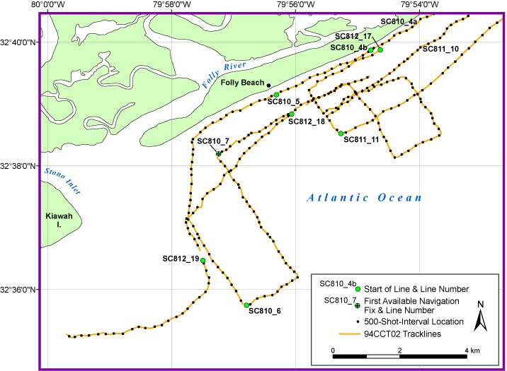
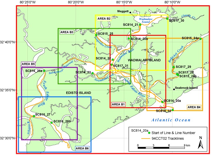
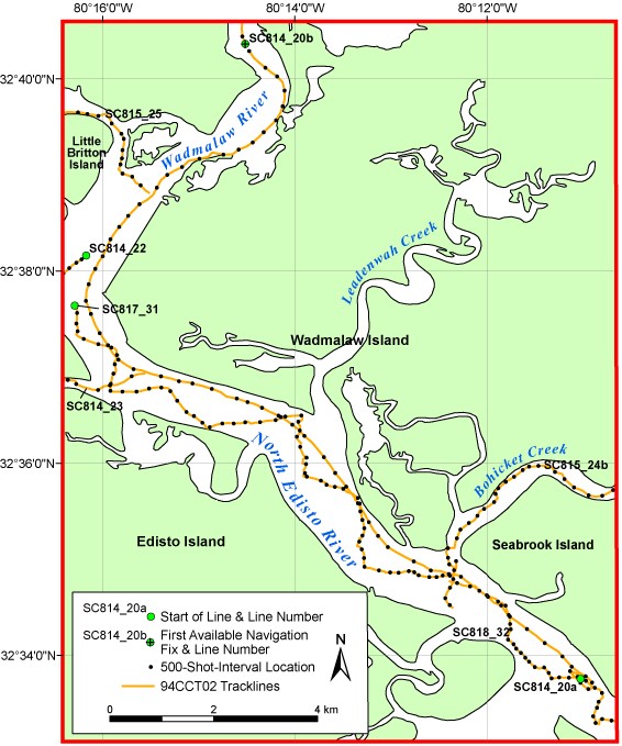
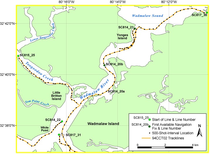
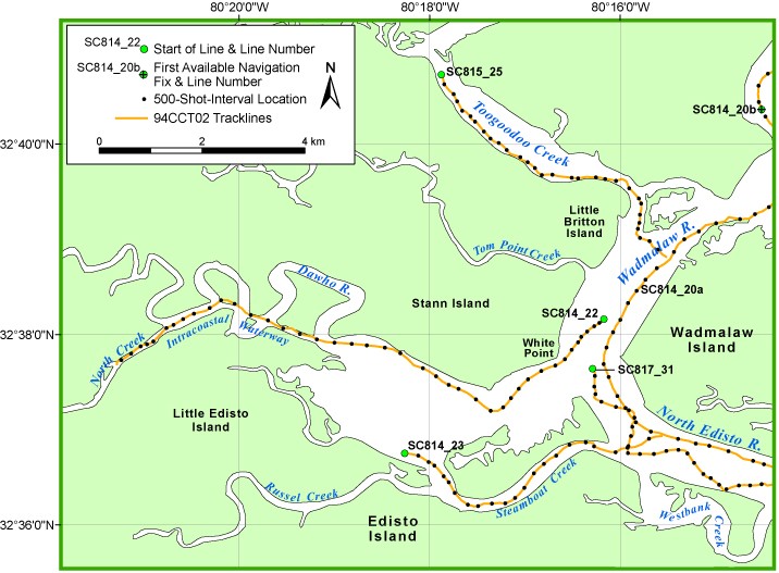
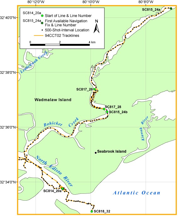
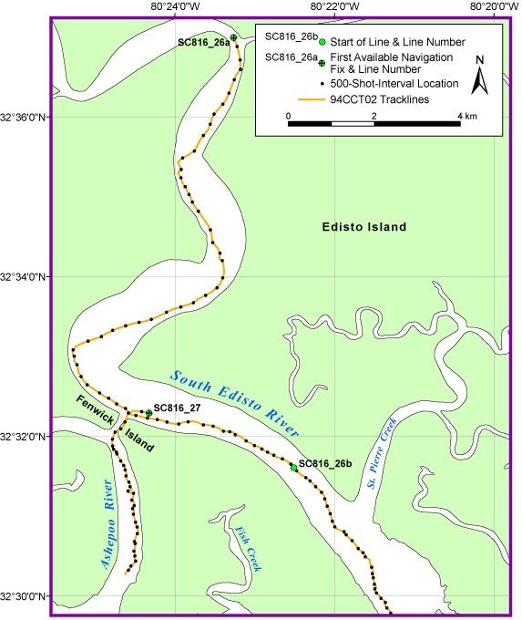
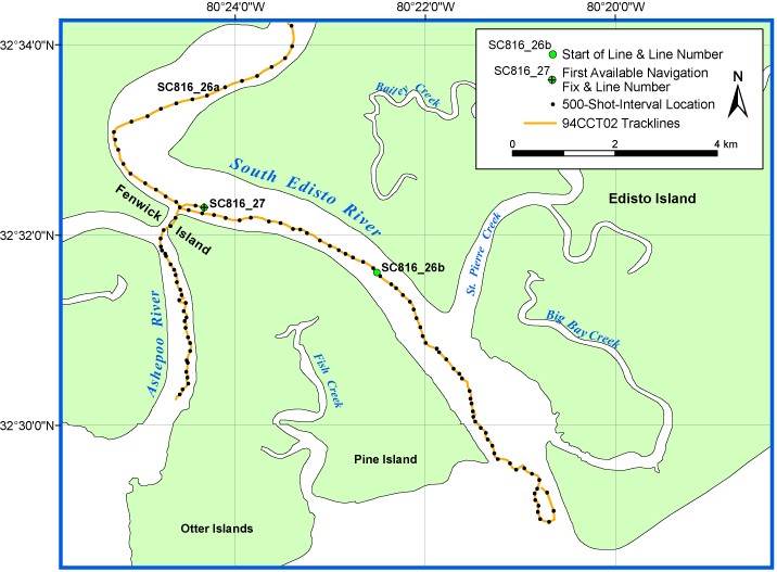
A Huntec power supply provided 60-375 joules per shot. Reflected energy was received by an Innovative Transducers, Inc. (ITI) ST-5 streamer and recorded by Triton Elics International, Inc. (TEI) Delph Seismic acquisition software. The streamer contains ten hydrophones evenly spaced over a length of 6 m. Refer to the observers' logbooks included in this archive (Data Series 147) for diagrams and descriptions of acquisition geometry, which changed several times throughout the cruise. The sample frequency of the data was 12 kHz. Record length was 80-124 ms. The shot rate was every 0.25 s. Shot spacing varied and should be calculated for each line of interest.

The unprocessed seismic data are stored in SEG-Y, integer, Motorola format, which is a standard digital format that can be read and manipulated by most seismic processing software packages (Barry and others, 1975). The SEG-Y formatted trace files have a .TRA extension. Additional recording parameters for each trace file can also be found in the .PAR file associated with each .TRA file. However, the .PAR and .PLN files included here are only needed to process or display the data with TEI Delph Seismic software. Also provided are example Seismic Unix scripts that allow the user to strip off navigation fixes from the SEG-Y headers, along with a fix for every 500 shots, and produce a filtered and gained GIF image of each profile.

Time_Period_of_Content:
Time_Period_Information:
Range_of_Dates/Times:
Beginning_Date: 19940809
Ending_Date: 19940819
Currentness_Reference: Data collection interval
Status:
Progress: Complete
Maintenance_and_Update_Frequency: None planned
Spatial_Domain:
Bounding_Coordinates:
West_Bounding_Coordinate: -80.421363
East_Bounding_Coordinate: -79.759880
North_Bounding_Coordinate: 32.780265
South_Bounding_Coordinate: 32.483093
Keywords:
Theme:
Theme_Keyword_Thesaurus: None
Theme_Keyword: marine seismic reflection
Theme_Keyword: boomer
Theme_Keyword: SEG-Y
Theme_Keyword: 94CCT02
Theme_Keyword: Coastal Change and Transport
Place:
Place_Keyword_Thesaurus: None
Place_Keyword: South Carolina
Place_Keyword: Intracoastal Waterway
Place_Keyword: Wappoo Creek
Place_Keyword: Atlantic Ocean
Place_Keyword: Ashley River
Place_Keyword: Charleston Harbor
Place_Keyword: North Edisto River
Place_Keyword: Wadmalaw River
Place_Keyword: Wadmalaw Sound
Place_Keyword: Dawho River
Place_Keyword: North Creek
Place_Keyword: Steamboat Creek
Place_Keyword: Bohicket Creek
Place_Keyword: Toogoodoo Creek
Place_Keyword: South Edisto River
Place_Keyword: Fenwick Cut
Place_Keyword: Ashepoo River
Access_Constraints: None. These data are held in the public domain.
Use_Constraints:
The U.S. Geological Survey requests to be acknowledged as the originator of the data in future products or derivative research.
Point_of_Contact:
Contact_Information:
Contact_Person_Primary:
Contact_Person: Jack L. Kindinger
Contact_Organization: U.S. Geological Survey
Contact_Position: Oceanographer
Contact_Address:
Address_Type: mailing and physical
Address: 600 4th Street South
City: St. Petersburg
State_or_Province: FL
Postal_Code: 33701
Country: USA
Contact_Voice_Telephone: (727) 803-8747, ext. 3018
Contact_Electronic_Mail_Address: jkindinger@usgs.gov
Browse_Graphic:
Browse_Graphic_File_Name: DVD/maps/all.jpg
Browse_Graphic_File_Description:
Trackline map of all digital boomer seismic reflection data collected during USGS Cruise 94CCT02. This map was created at a scale of 1:350,000. Refer to the Lineage section below for the trackline map creation process.
Browse_Graphic_File_Type: JPEG
Browse_Graphic:
Browse_Graphic_File_Name: DVD/maps/area_a.jpg
Browse_Graphic_File_Description:
Trackline map of digital boomer seismic reflection data collected in Area A (refer to Area A of the full survey area map) during USGS Cruise 94CCT02. This map was created at a scale of 1:160,000. Refer to the Lineage section below for the trackline map creation process.
Browse_Graphic_File_Type: JPEG
Browse_Graphic:
Browse_Graphic_File_Name: DVD/maps/area_a1.jpg
Browse_Graphic_File_Description:
Trackline map of digital boomer seismic reflection data collected in Area A1 (refer to Area A1 of the Area A map) during USGS Cruise 94CCT02. This map was created at a scale of 1:60,000. Refer to the Lineage section below for the trackline map creation process.
Browse_Graphic_File_Type: JPEG
Browse_Graphic:
Browse_Graphic_File_Name: DVD/maps/area_a2.jpg
Browse_Graphic_File_Description:
Trackline map of digital boomer seismic reflection data collected in Area A2 (refer to Area A2 of the Area A map) during USGS Cruise 94CCT02. This map was created at a scale of 1:60,000. Refer to the Lineage section below for the trackline map creation process.
Browse_Graphic_File_Type: JPEG
Browse_Graphic:
Browse_Graphic_File_Name: DVD/maps/area_a3.jpg
Browse_Graphic_File_Description:
Trackline map of digital boomer seismic reflection data collected in Area A3 (refer to Area A3 of the Area A map) during USGS Cruise 94CCT02. This map was created at a scale of 1:60,000. Refer to the Lineage section below for the trackline map creation process.
Browse_Graphic_File_Type: JPEG
Browse_Graphic:
Browse_Graphic_File_Name: DVD/maps/area_a4.jpg
Browse_Graphic_File_Description:
Trackline map of digital boomer seismic reflection data collected in Area A4 (refer to Area A4 of the Area A map) during USGS Cruise 94CCT02. This map was created at a scale of 1:60,000. Refer to the Lineage section below for the trackline map creation process.
Browse_Graphic_File_Type: JPEG
Browse_Graphic:
Browse_Graphic_File_Name: DVD/maps/area_b.jpg
Browse_Graphic_File_Description:
Trackline map of digital boomer seismic reflection data collected in Area B (refer to Area B of the full survey area map) during USGS Cruise 94CCT02. This map was created at a scale of 1:160,000. Refer to the Lineage section below for the trackline map creation process.
Browse_Graphic_File_Type: JPEG
Browse_Graphic:
Browse_Graphic_File_Name: DVD/maps/area_b1.jpg
Browse_Graphic_File_Description:
Trackline map of digital boomer seismic reflection data collected in Area B1 (refer to Area B1 of the Area B map) during USGS Cruise 94CCT02. This map was created at a scale of 1:60,000. Refer to the Lineage section below for the trackline map creation process.
Browse_Graphic_File_Type: JPEG
Browse_Graphic:
Browse_Graphic_File_Name: DVD/maps/area_b2.jpg
Browse_Graphic_File_Description:
Trackline map of digital boomer seismic reflection data collected in Area B2 (refer to Area B2 of the Area B map) during USGS Cruise 94CCT02. This map was created at a scale of 1:60,000. Refer to the Lineage section below for the trackline map creation process.
Browse_Graphic_File_Type: JPEG
Browse_Graphic:
Browse_Graphic_File_Name: DVD/maps/area_b3.jpg
Browse_Graphic_File_Description:
Trackline map of digital boomer seismic reflection data collected in Area B3 (refer to Area B3 of the Area B map) during USGS Cruise 94CCT02. This map was created at a scale of 1:60,000. Refer to the Lineage section below for the trackline map creation process.
Browse_Graphic_File_Type: JPEG
Browse_Graphic:
Browse_Graphic_File_Name: DVD/maps/area_b4.jpg
Browse_Graphic_File_Description:
Trackline map of digital boomer seismic reflection data collected in Area B4 (refer to Area B4 of the Area B map) during USGS Cruise 94CCT02. This map was created at a scale of 1:60,000. Refer to the Lineage section below for the trackline map creation process.
Browse_Graphic_File_Type: JPEG
Browse_Graphic:
Browse_Graphic_File_Name: DVD/maps/area_b5.jpg
Browse_Graphic_File_Description:
Trackline map of digital boomer seismic reflection data collected in Area B5 (refer to Area B5 of the Area B map) during USGS Cruise 94CCT02. This map was created at a scale of 1:60,000. Refer to the Lineage section below for the trackline map creation process.
Browse_Graphic_File_Type: JPEG
Browse_Graphic:
Browse_Graphic_File_Name: DVD/maps/area_b6.jpg
Browse_Graphic_File_Description:
Trackline map of digital boomer seismic reflection data collected in Area B6 (refer to Area B6 of the Area B map) during USGS Cruise 94CCT02. This map was created at a scale of 1:60,000. Refer to the Lineage section below for the trackline map creation process.
Browse_Graphic_File_Type: JPEG
Data_Set_Credit:
Funding and/or support for this study were provided by the USGS Office of Energy and Marine Geology and Coastal Carolina University. This document was improved by the reviews of N.T. Edgar and R.A. Morton of the USGS in St. Petersburg, Florida.

Data_Quality_Information:
Attribute_Accuracy:
Attribute_Accuracy_Report:
The validity or accuracy of marine seismic reflection profiles is highly qualitative and depends on equipment and operating condition variables. Visual inspection of the images rendered from the data did not show any major anomalies.
Logical_Consistency_Report:
This data set is from one cruise with consistent instrument calibrations.
Completeness_Report:
These data are collected along tracklines (2-D) and are therefore inherently incomplete. Geologic details between lines must be inferred. Lines SC810_7, SC811_12, SC811_13, SC814_20b, SC814_21, SC815_24a, SC816_26a, and SC816_27 are missing navigation for the first 100 shots or more.
Positional_Accuracy:
Horizontal_Positional_Accuracy:
Horizontal_Positional_Accuracy_Report:
As the seismic reflection data were acquired, the position of the vessel was continuously determined by a Trimble Nav Trac GPS receiver with an attached DGPS beacon receiver, which is accurate within 3 m. Positions were recorded and written in latitude and longitude to the trace headers about every 30-60 s. The ASCII navigation files and trackline maps have not been corrected to reflect the estimated 15-m offset between the shotpoint and the GPS antenna. Refer to the observers' logbooks included in this archive (Data Series 147) for diagrams and descriptions of acquisition geometry, which changed several times throughout the cruise.
Vertical_Positional_Accuracy:
Vertical_Positional_Accuracy_Report:
Boomer data are relative to sea level. However, varying recorded static shifts of the data have been known to occur. Therefore, these data are not to be used for bathymetry.
Lineage:
Process_Step:
Process_Description:
Boomer processing: TEI Delph Seismic software was used to convert the original trace files from nonstandard ELICS format to standard SEG-Y format. The original trace files for lines SC810_4, SC814_20, SC815_24, and SC816_26 were divided into two trace files each (e.g., SC810_4 became SC810_4a and SC810_4b) because the original total number of traces exceeded the maximum allowed by the processing software. The SEG-Y data were processed with Seismic Unix to produce GIF images of the seismic profiles included in this report. A representative boomer processing sequence consisted of: 1) Bandpass filter: 300-500-2500-3000 Hz, 2) Automatic gain control, 3) Postscript display, and 4) Conversion of Postscript image to a GIF image.
Process_Date: 2004
Process_Step:
Process_Description:
Navigation processing: Shotpoint navigation files were extracted from the trace headers of each line with TEI Delph Seismic software during the format conversion process. Some lines required editing to fix incorrect shot numbers, and Delph Seismic was used to reinject the navigation into the headers. Navigation files for all lines were edited to remove or correct spurious data points. These files were then processed with PROJ.4 software (<http://www.remotesensing.org/proj>) to generate Zone 17 UTMs from latitude and longitude and reformatted for use with Environmental Systems Research Institute (ESRI) GIS software. The 500-shot-interval location files were extracted using Seismic Unix scripts and processed in the same manner as the navigation files.
Process_Date: 2004
Process_Step:
Process_Description:
Trackline map creation: The trackline maps provided in this archive were created using ESRI ArcView 3.3 and ArcGIS 8.3 software, exported to Adobe Illustrator for further editing, and saved in JPEG format. The maps are in geographic coordinates, NAD83 (unprojected). The USGS is the originator of all layers except the cities layer, which is an ESRI data set.
Process_Date: 2004
Process_Step:
Process_Description:
Data Series preparation: In addition to the process steps described above, the following steps were taken to produce this Data Series: the observers' handwritten logbooks were scanned and saved as PDF files, FACS logs were created using the handwritten logs and personal accounts of the crew members, and an HTML-based format was used to present the various parts of this archive.
Process_Date: 2004

Spatial_Data_Organization_Information:
Indirect_Spatial_Reference:
Horizontal X and Y locations (latitude and longitude and UTMs) for each shot are provided as ASCII text files, along with the date and time (UTC) the shot was recorded.

Spatial_Reference_Information:
Horizontal_Coordinate_System_Definition:
Geographic:
Latitude_Resolution: 0.0000027
Longitude_Resolution: 0.0000027
Geographic_Coordinate_Units: decimal degrees
Geodetic_Model:
Horizontal_Datum_Name: WGS84
Ellipsoid_Name: WGS84
Semi-major_Axis: 6378137
Denominator_of_Flattening_Ratio: 298.257

Entity_and_Attribute_Information:
Overview_Description:
Entity_and_Attribute_Overview:
Binary data file: Trace data are available as binary files in SEG-Y format. These files have a .TRA extension and range in size from 5 to 98 MB.
Entity_and_Attribute_Detail_Citation:
Barry, K.M., Cavers, D.A., and Kneale, C.W., 1975, Recommended standards for digital tape formats: Geophysics, v. 40, n. 2, p. 344-352. Also available online at: <http://www.seg.org/publications/tech-stand>.
Entity_and_Attribute_Detail_Citation:
Zihlman, F.N., 1992, DUMPSEGY V1.0: A program to examine the contents of SEG-Y disk-image seismic data: U.S. Geological Survey Open-File Report 92-590, 28 p.
Entity_and_Attribute_Overview:
Graphic image file: Profiles are available as GIF images that range in size from 248 KB to 4 MB. Trackline maps, which range in size from 73 to 133 KB, are JPEG images that contain links to the seismic profile GIF images.
Entity_and_Attribute_Overview:
Navigation file: Navigation files are available as ASCII text files. The raw (unedited) navigation file measures 166 KB, the edited navigation file measures 201 MB, and the edited 500-shot-interval location file measures 77 KB.
Entity_and_Attribute_Overview:
GIS file: The GIS project used to create the trackline maps is provided as a zip file composed of map documents, shapefiles, and metadata. The map documents range in size from 779 to 880 KB, and the shapefiles range in size from 5 KB to 29 MB.

Distribution_Information:
Distributor:
Contact_Information:
Contact_Person_Primary:
Contact_Person: Shawn Dadisman
Contact_Organization: U.S. Geological Survey
Contact_Position: Geologist
Contact_Address:
Address_Type: mailing and physical
Address: 600 4th Street South
City: St. Petersburg
State_or_Province: FL
Postal_Code: 33701
Country: USA
Contact_Voice_Telephone: (727) 803-8747, ext. 3029
Contact_Electronic_Mail_Address: sdadisman@usgs.gov
Contact_Instructions:
Data may be available on-line only by special arrangement with the distributor above.
Resource_Description: U.S. Geological Survey Data Series 147
Distribution_Liability:
This DVD publication was prepared by an agency of the United States Government. Neither the United States Government nor any agency thereof nor any of their employees makes any warranty, expressed or implied, or assumes any legal liability or responsibility for the accuracy, completeness, or usefulness of any information, apparatus, product, or process disclosed in this report or represents that its use would not infringe privately owned rights. Reference therein to any specific commercial product, process, or service by trade name, trademark, manufacturer, or otherwise does not constitute or imply its endorsement, recommendation, or favoring by the United States Government or any agency thereof.

Although all data and software published on this DVD have been used by the USGS, no warranty, expressed or implied, is made by the USGS as to the accuracy of the data and related materials and (or) the functioning of the software. The act of distribution shall not constitute any such warranty, and no responsibility is assumed by the USGS in the use of these data, software, or related materials.

Standard_Order_Process:
Digital_Form:
Digital_Transfer_Information:
Format_Name: SEG-Y
Format_Information_Content:
The SEG-Y standard format (Barry and others, 1975) consists of the following: a 3,600-byte reel identification header, with the first 3,200 bytes consisting of an ASCII header block followed by a 400-byte binary header block, both of which include information specific to line and reel number; a trace data block that follows the reel identification header, with the first 240 bytes of each trace block consisting of the binary trace identification header; and seismic data samples that follow the trace identification header.
File_Decompression_Technique: None
Transfer_Size: 1,580 MB
Digital_Transfer_Option:
Offline_Option:
Offline_Media: DVD
Recording_Format: ISO 9660
Compatibility_Information: UNIX, LINUX, DOS, Macintosh
Digital_Form:
Digital_Transfer_Information:
Format_Name: map document, shapefile, metadata
Format_Information_Content:
The GIS project used to create the trackline maps is composed of map documents, shapefiles, and metadata. Map documents were created using ESRI ArcGIS 8.3 software. The shapefiles provided may also be viewed using other versions of ArcView, ArcGIS, or public domain software ArcExplorer (<http://www.esri.com/software/arcexplorer/>).
File_Decompression_Technique: unzip
Transfer_Size: 21 MB
Digital_Transfer_Option:
Online_Option:
Computer_Contact_Information:
Network_Address:
Network_Resource_Name: DVD/software/arc/arc.zip
Fees:
Prices vary.
Ordering_Instructions:
Publications are available from USGS Information Services, Box 25286, Federal Center, Denver, CO 80225-0046 (telephone: 1-888-ASK-USGS, e-mail: infoservices@usgs.gov).
Technical_Prerequisites:
Use of SEG-Y data requires specialized seismic processing software, such as public domain software Seismic Unix (<http://www.cwp.mines.edu/cwpcodes/>).

Metadata_Reference_Information:
Metadata_Date: 20051125
Metadata_Contact:
Contact_Information:
Contact_Person_Primary:
Contact_Person: Karynna Calderon
Contact_Organization: CSC, contracted by USGS
Contact_Position: Geographer
Contact_Address:
Address_Type: mailing and physical
Address: 600 4th Street South
City: St. Petersburg
State_or_Province: FL
Postal_Code: 33701
Country: USA
Contact_Voice_Telephone: (727) 803-8747, ext. 3143
Contact_Electronic_Mail_Address: kcalderon@usgs.gov
Metadata_Standard_Name: Content Standard for Digital Geospatial Metadata
Metadata_Standard_Version: FGDC-STD-001-1998

Home | Acronyms | Contents | Navigation | Profiles | Logs | Metadata | Software

Accessibility FOIA Privacy Policies and Notices

Take Pride in America home page. FirstGov button U.S. Department of the Interior | U.S. Geological Survey
URL: pubsdata.usgs.gov/pubs/ds/2005/147/html/metadata.html
Page Contact Information: Publishing Services
Page Last Modified: Monday, 28-Nov-2016 12:19:45 EST