USGS, NOAA, FEMA
U.S. Geological Survey
Data Series 236
Version 1.0
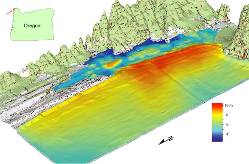
IntroductionThe Federal Emergency Management Agency (FEMA) Federal Insurance Rate Map (FIRM) guidelines do not currently exist for conducting and incorporating tsunami hazard assessments that reflect the substantial advances in tsunami research achieved in the last two decades; this conclusion is the result of two FEMA-sponsored workshops and the associated Tsunami Focused Study (Chowdhury and others, 2005). Therefore, as part of FEMA's Map Modernization Program, a Tsunami Pilot Study was carried out in the Seaside/Gearhart, Oregon, area to develop an improved Probabilistic Tsunami Hazard Analysis (PTHA) methodology and to provide recommendations for improved tsunami hazard assessment guidelines (Tsunami Pilot Study Working Group, 2006). The Seaside area was chosen because it is typical of many coastal communities in the section of the Pacific Coast from Cape Mendocino to the Strait of Juan de Fuca, and because State agencies and local stakeholders expressed considerable interest in mapping the tsunami threat to this area. The study was an interagency effort by FEMA, U.S. Geological Survey, and the National Oceanic and Atmospheric Administration (NOAA), in collaboration with the University of Southern California, Middle East Technical University, Portland State University, Horning Geoscience, Northwest Hydraulics Consultants, and the Oregon Department of Geological and Mineral Industries. We present the spatial (geographic information system, GIS) data from the pilot study in standard GIS formats and provide files for visualization in Google Earth, a global map viewer. Perspective view of 500-year tsunami in the Seaside/Gearhart, Oregon, pilot study area. Tsunami wave heights (m, referenced to mean high water) with a 0.2 percent annual probability of exceedance. Wave heights include the effects of tides. Vertical exaggeration 10x; view looks southeastward. |
| Frank | González | NOAA/PMEL |
| Eric | Geist | U.S. Geological Survey |
| Costas | Synolakis | Univ. of Southern California |
| Diego | Arcas | NOAA/PMEL |
| Doug | Bellomo | FEMA, Dept. of Homeland Security |
| David | Carlton | FEMA, Dept. of Homeland Security |
| Tom | Horning | Horning Geoscience |
| Bruce | Jaffe | U.S. Geological Survey |
| Jeff | Johnson | Northwest Hydraulics Consultants |
| Utku | Kanoglu | Middle East Technical University, Ankara, Turkey |
| Hal | Mofjeld | NOAA/PMEL |
| Jean | Newman | NOAA/PMEL |
| Tom | Parsons | U.S. Geological Survey |
| Robert | Peters | U.S. Geological Survey |
| Curt | Peterson | Portland State University |
| George | Priest | Oregon Dept. of Geology & Minerals |
| Vasily | Titov | NOAA/PMEL |
| Angie | Venturato | NOAA/PMEL |
| Joe | Weber | FEMA, Dept. of Homeland Security |
| Florence | Wong | U.S. Geological Survey |
| Ahmet | Yalciner | Middle East Technical University, Ankara, Turkey |
For more information, contact
Florence L. Wong
United States Geological Survey
Coastal and Marine Geology Program
345 Middlefield Road, MS 999
Menlo Park, California 94025
Angie J. Venturato
NOAA Center for Tsunami Research
NOAA/PMEL - UW/JISAO
7600 Sand Point Way, NE
Seattle, Washington, US 98115
Eric L. Geist
United States Geological Survey
Coastal and Marine Geology Program
345 Middlefield Road, MS 999
Menlo Park, California 94025
Suggested citation:
Wong, F.L., Venturato, A.J., and Geist, E.L., 2006, Seaside, Oregon, tsunami pilot study—Modernization of FEMA flood hazard maps: GIS Data: U.S. Geological Survey Data Series 236 [https://pubs.usgs.gov/ds/2006/236/].
| -Introduction -Revisions and Updates -Acknowledgments -Contacts |
|
see also: USGS OFR 2006-1234: Seaside, Oregon, Tsunami Pilot Study - Modernization of FEMA Flood Hazard Maps USGS Western Coastal & Marine Geology (WCMG) |
Top | Menu | Abbreviations

![]() U.S. Department of the Interior | U.S. Geological Survey
U.S. Department of the Interior | U.S. Geological Survey
URL: https://pubsdata.usgs.gov/pubs/ds/2006/236/index.shtml
Page Contact Information: Florence L. Wong
Page Last Modified: Monday, 28-Nov-2016 12:04:10 EST(flw)