|
Project Description
These remotely sensed, geographically referenced elevation measurements of Lidar-derived first surface (FS) and bare earth (BE) topography were produced as a collaborative effort between the U.S. Geological Survey (USGS), Florida Integrated Science Center (FISC),
St. Petersburg, FL; the National Park Service (NPS), Northeast Coastal and Barrier Network, Kingston, RI; and the National Aeronautics and Space Administration (NASA), Wallops Flight Facility, VA.
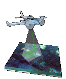
This project provides highly detailed and accurate datasets of Fire Island National Seashore in New York, acquired on April 29-30 and May 15-16, 2007. The datasets are made available for use as a management tool to research scientists and natural resource managers. An innovative airborne Lidar instrument originally developed at the NASA Wallops Flight Facility, and known as the Experimental Advanced Airborne Research Lidar
(EAARL)
was used during data acquisition. The EAARL system is a raster-scanning, waveform-resolving, green-wavelength (532-nanometer) Lidar
designed to map near-shore bathymetry, topography, and vegetation
structure simultaneously. The EAARL
sensor suite includes the raster-scanning, water-penetrating
full-waveform adaptive Lidar,
a down-looking red-green-blue (RGB) digital
camera, a high-resolution multi-spectral color infrared (CIR) camera,
two precision
dual-frequency kinematic carrier-phase GPS receivers and an integrated miniature digital inertial measurement unit, which provide for submeter georeferencing of each laser sample. The nominal EAARL
platform is a twin-engine Cessna 310 aircraft, but the instrument may
be deployed on a range of light aircraft. A single pilot, a Lidar operator, and a data
analyst constitute the crew for most survey operations. This sensor has
the potential to make significant contributions in measuring sub-aerial
and submarine coastal topography within cross-environmental surveys.
Elevation measurements were collected over the survey
area using the EAARL system, and the resulting data were then processed using the Airborne Lidar Processing System (ALPS), a custom-built
processing system developed in a NASA-USGS collaboration. ALPS supports the
exploration and processing of Lidar
data in an interactive or batch mode. Modules for pre-survey flight
line definition, flight path plotting, Lidar raster and waveform
investigation, and digital camera image playback have been developed.
Processing algorithms have been developed to extract the range to the
first and last significant return within each waveform. ALPS is routinely used to create maps that represent submerged or first surface topography. Specialized filtering algorithms have been implemented to determine the "bare earth" under vegetation from a point cloud of last return elevations.
Selected References
Nayegandhi, A., Brock, J.C., and Wright, C.W., in press, Small-footprint, waveform-resolving Lidar estimation of submerged and sub-canopy topography in coastal environments: Journal of Remote Sensing.
Brock, J.C., Wright, C.W., Sallenger, A.H., Krabill, W.B., and Swift, R.N., 2002, Basis and methods of NASA airborne topographic mapper Lidar surveys for coastal studies: Journal of Coastal Research, v. 18, no. 1, p. 1–13.
Sallenger, A.H., Wright, C.W., and Lillycrop, J., 2005, Coastal impacts of the 2004 hurricanes measured with airborne Lidar; initial results: Shore and Beach, v. 73 nos. 2-3, p. 10-14.
Crane, Michael, Clayton, Tonya, Raabe, Ellen, Stoker, Jason, Handley, Larry, Bawden, Gerald, Morgan, Karen, and Queija, Vivian, 2004, Report of the U.S. Geological Survey Lidar workshop sponsored by the Land Remote Sensing Program and held in St. Petersburg, FL, November 2002: U.S. Geological Survey Open-File Report 2004-1456, 72 p.
Resources Included
Readme.txt File
|