U.S. Geological Survey Data Series 469
ABSTRACT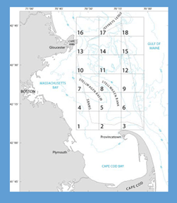
The U.S. Geological Survey, in collaboration with National Oceanic and Atmospheric Administration’s National Marine Sanctuary Program, conducted seabed mapping and related research in the Stellwagen Bank National Marine Sanctuary region from 1993 to 2004. The mapped area is approximately 3,700 km² (1,100 nmi²) in size and was subdivided into 18 quadrangles. An extensive series of sea-floor maps of the region based on multibeam sonar surveys has been published as paper maps and online in digital format (PDF, EPS, PS). In addition, 2,628 seabed-sediment samples were collected and analyzed and are in the usSEABED: Atlantic Coast Offshore Surficial Sediment Data Release. This report presents for viewing and downloading the more than 10,600 still seabed photographs that were acquired during the project. The digital images are provided in thumbnail, medium (1536 x 1024 pixels), and high (3071 x 2048) resolution. The images can be viewed by quadrangle on the U.S. Geological Survey Woods Hole Coastal and Marine Science Center’s photograph database. Photograph metadata are embedded in each image in Exchangeable Image File Format and also provided in spreadsheet format. Published digital topographic maps and descriptive text for seabed features are included here for downloading and serve as context for the photographs. An interactive topographic map for each quadrangle shows locations of photograph stations, and each location is linked to the photograph database. This map also shows stations where seabed sediment was collected for texture analysis; the results of grain-size analysis and associated metadata are presented in spreadsheet format. |
Posted July 2010 For additional information contact: Part or all of this report is presented in Portable Document Format (PDF); the latest version of Adobe Reader or similar software is required to view it. Download the latest version of Adobe Reader, free of charge. |
Valentine, P.C., Gallea, L.B., Blackwood, D.S., and Twomey, E.R., 2010, Seabed photographs, sediment texture analyses, and sun-illuminated sea floor topography in the Stellwagen Bank National Marine Sanctuary region off Boston, Massachusetts: U.S. Geological Survey Data Series 469, available at https://pubs.usgs.gov/ds/469/.
Abstract
Seabed Photograph Collection and Processing
Seabed Sediment Collection, Processing, and Analysis
Quadrangle 1
Quadrangle 2
Quadrangle 3
Quadrangle 4
Quadrangle 5
Quadrangle 6
Quadrangle 7
Quadrangle 8
Quadrangle 9
Quadrangle 10
Quadrangle 11
Quadrangle 12
Quadrangle 13
Quadrangle 14
Quadrangle 15
Quadrangle 16
Quadrangle 17
Quadrangle 18
Description of Sea-Floor Topography and Geographic Names
Data Catalog
Selected References

![]() U.S. Department of the Interior |
U.S. Geological Survey
U.S. Department of the Interior |
U.S. Geological Survey
[an error occurred while processing this directive]
URL: https://pubsdata.usgs.gov
Page Contact Information: Contact USGS
Page Last Modified: Monday, 28-Nov-2016 15:19:59 EST
