Gallea, Leslie B. , 2009, SB_SEDSAMPLES (Shapefile): Geographic Locations of Seabed Sediment Samples from the Stellwagen Bank National Marine Sanctuary Region: U.S. Geological Survey Data Series 469, Version 1.0, U.S. Geological Survey, Coastal and Marine Geology Program, Woods Hole Coastal and Marine Science Center, Woods Hole, MA.This is part of the following larger work.Online Links:
Valentine, Page C. , Gallea, Leslie B. , Blackwood, Dann S. , and Twomey, Erin R. , 2009, Seabed Photographs, Sediment Texture Analyses, and Sun-illuminated Sea Floor Topography in the Stellwagen Bank National Marine Sanctuary Region off Boston, Massachusetts: U.S. Geological Survey Data Series 469, Version 1.0, U.S. Geological Survey, Coastal and Marine Geology Program, Woods Hole Coastal and Marine Science Center, Woods Hole, MA.Online Links:
This is a Vector data set. It contains the following vector data types (SDTS terminology):
Horizontal positions are specified in geographic coordinates, that is, latitude and longitude. Latitudes are given to the nearest 0.000001. Longitudes are given to the nearest 0.000001. Latitude and longitude values are specified in Decimal degrees.
The horizontal datum used is North American Datum of 1983.
The ellipsoid used is Geodetic Reference System 80.
The semi-major axis of the ellipsoid used is 6378137.000000.
The flattening of the ellipsoid used is 1/298.257222.
Sequential unique whole numbers that are automatically generated.
Coordinates defining the features.
Character set
| Range of values | |
|---|---|
| Minimum: | -70.597750 |
| Maximum: | -70.033220 |
| Range of values | |
|---|---|
| Minimum: | 42.084650 |
| Maximum: | 42.798900 |
| Formal codeset | |
|---|---|
| Codeset Name: | ablj97020 |
| Codeset Source: | <http://quashnet.er.usgs.gov/data/1997/97020/> |
| Formal codeset | |
|---|---|
| Codeset Name: | andr95015 |
| Codeset Source: | <http://quashnet.er.usgs.gov/data/1995/95015/> |
| Formal codeset | |
|---|---|
| Codeset Name: | andr95036 |
| Codeset Source: | <http://quashnet.er.usgs.gov/data/1995/95036/> |
| Formal codeset | |
|---|---|
| Codeset Name: | argo94014 |
| Codeset Source: | <http://quashnet.er.usgs.gov/data/1994/94014/> |
| Formal codeset | |
|---|---|
| Codeset Name: | cand00065 |
| Codeset Source: | <http://quashnet.er.usgs.gov/data/2000/00065/> |
| Formal codeset | |
|---|---|
| Codeset Name: | cand98022 |
| Codeset Source: | <http://quashnet.er.usgs.gov/data/1998/98022/> |
| Formal codeset | |
|---|---|
| Codeset Name: | conn03014 |
| Codeset Source: | <http://quashnet.er.usgs.gov/data/2003/03014/> |
| Formal codeset | |
|---|---|
| Codeset Name: | dian96025 |
| Codeset Source: | <http://quashnet.er.usgs.gov/data/1996/96025/> |
| Formal codeset | |
|---|---|
| Codeset Name: | dlwr93006 |
| Codeset Source: | <http://quashnet.er.usgs.gov/data/1993/93006/> |
| Formal codeset | |
|---|---|
| Codeset Name: | dlwr93030 |
| Codeset Source: | <http://quashnet.er.usgs.gov/data/1993/93030/> |
| Formal codeset | |
|---|---|
| Codeset Name: | dlwr99011 |
| Codeset Source: | <http://quashnet.er.usgs.gov/data/1999/99011/> |
| Formal codeset | |
|---|---|
| Codeset Name: | ferl00011 |
| Codeset Source: | <http://quashnet.er.usgs.gov/data/2000/00011/> |
| Formal codeset | |
|---|---|
| Codeset Name: | ferl02029 |
| Codeset Source: | <http://quashnet.er.usgs.gov/data/2002/02029/> |
| Formal codeset | |
|---|---|
| Codeset Name: | ferl94004 |
| Codeset Source: | <http://quashnet.er.usgs.gov/data/1994/94004/> |
| Formal codeset | |
|---|---|
| Codeset Name: | ferl95012 |
| Codeset Source: | <http://quashnet.er.usgs.gov/data/1995/95012/> |
| Formal codeset | |
|---|---|
| Codeset Name: | ferl96038 |
| Codeset Source: | <http://quashnet.er.usgs.gov/data/1996/96038/> |
| Formal codeset | |
|---|---|
| Codeset Name: | ferl97033 |
| Codeset Source: | <http://quashnet.er.usgs.gov/data/1997/97033/> |
| Formal codeset | |
|---|---|
| Codeset Name: | ferl98029 |
| Codeset Source: | <http://quashnet.er.usgs.gov/data/1998/98029/> |
| Formal codeset | |
|---|---|
| Codeset Name: | isbl96037 |
| Codeset Source: | <http://quashnet.er.usgs.gov/data/1996/96037/> |
| Formal codeset | |
|---|---|
| Codeset Name: | isbl98017 |
| Codeset Source: | <http://quashnet.er.usgs.gov/data/1998/98017/> |
| Formal codeset | |
|---|---|
| Codeset Name: | isbl99024 |
| Codeset Source: | <http://quashnet.er.usgs.gov/data/1999/99024/> |
| Formal codeset | |
|---|---|
| Codeset Name: | andr93023 |
| Codeset Source: | <http://quashnet.er.usgs.gov/data/1993/93023/> |
| Formal codeset | |
|---|---|
| Codeset Name: | fstr04010 |
| Codeset Source: | <http://quashnet.er.usgs.gov/data/2004/04010/> |
| Formal codeset | |
|---|---|
| Codeset Name: | conn01060 |
| Codeset Source: | <http://quashnet.er.usgs.gov/data/2001/01060/> |
| Range of values | |
|---|---|
| Minimum: | 15 |
| Maximum: | 190 |
| Units: | meters |
| Range of values | |
|---|---|
| Minimum: | 1993 |
| Maximum: | 2004 |
Character set
Character set
| Value | Definition |
|---|---|
| 0 |
| Value | Definition |
|---|---|
| 2 | Depth in sediment in cm |
| Range of values | |
|---|---|
| Minimum: | 7.4195 |
| Maximum: | 1727.1 |
| Units: | grams |
| Resolution: | 0.01 |
| Range of values | |
|---|---|
| Minimum: | 0 |
| Maximum: | 52.3 |
| Units: | percent |
| Resolution: | 0.01 |
| Range of values | |
|---|---|
| Minimum: | 0 |
| Maximum: | 86.8 |
| Units: | percent |
| Resolution: | 0.01 |
| Range of values | |
|---|---|
| Minimum: | 0 |
| Maximum: | 99.45 |
| Units: | percent |
| Resolution: | 0.01 |
| Range of values | |
|---|---|
| Minimum: | 0.55 |
| Maximum: | 100 |
| Units: | percent |
| Resolution: | 0.01 |
| Range of values | |
|---|---|
| Minimum: | 0 |
| Maximum: | 98.21 |
| Units: | percent |
| Resolution: | 0.01 |
| Range of values | |
|---|---|
| Minimum: | 0 |
| Maximum: | 12.07 |
| Units: | percent |
| Resolution: | 0.01 |
| Range of values | |
|---|---|
| Minimum: | 0 |
| Maximum: | 21.55 |
| Units: | percent |
| Resolution: | 0.01 |
| Range of values | |
|---|---|
| Minimum: | 0 |
| Maximum: | 23.89 |
| Units: | percent |
| Resolution: | 0.01 |
| Range of values | |
|---|---|
| Minimum: | 0 |
| Maximum: | 27.23 |
| Units: | percent |
| Resolution: | 0.01 |
| Range of values | |
|---|---|
| Minimum: | 0 |
| Maximum: | 27.4 |
| Units: | percent |
| Resolution: | 0.01 |
| Range of values | |
|---|---|
| Minimum: | 0 |
| Maximum: | 32.9 |
| Units: | percent |
| Resolution: | 0.01 |
| Range of values | |
|---|---|
| Minimum: | 0 |
| Maximum: | 55.92 |
| Units: | percent |
| Resolution: | 0.01 |
| Range of values | |
|---|---|
| Minimum: | 0 |
| Maximum: | 89.77 |
| Units: | percent |
| Resolution: | 0.01 |
| Range of values | |
|---|---|
| Minimum: | 0 |
| Maximum: | 89.19 |
| Units: | percent |
| Resolution: | 0.01 |
| Range of values | |
|---|---|
| Minimum: | 0 |
| Maximum: | 84.54 |
| Units: | percent |
| Resolution: | 0.01 |
| Range of values | |
|---|---|
| Minimum: | 0 |
| Maximum: | 74.01 |
| Units: | percent |
| Resolution: | 0.01 |
| Range of values | |
|---|---|
| Minimum: | 0 |
| Maximum: | 69.16 |
| Units: | percent |
| Resolution: | 0.01 |
| Range of values | |
|---|---|
| Minimum: | 0 |
| Maximum: | 84.97 |
| Units: | percent |
| Resolution: | 0.01 |
| Range of values | |
|---|---|
| Minimum: | 0 |
| Maximum: | 31.65 |
| Units: | percent |
| Resolution: | 0.01 |
| Range of values | |
|---|---|
| Minimum: | 0 |
| Maximum: | 50.65 |
| Units: | percent |
| Resolution: | 0.01 |
| Range of values | |
|---|---|
| Minimum: | 0 |
| Maximum: | 65.78 |
| Units: | percent |
| Resolution: | 0.01 |
| Range of values | |
|---|---|
| Minimum: | 0 |
| Maximum: | 61.76 |
| Units: | percent |
| Resolution: | 0.01 |
(508) 548-8700 x2339 (voice)
(508) 457-2310 (FAX)
pvalenting@usgs.gov
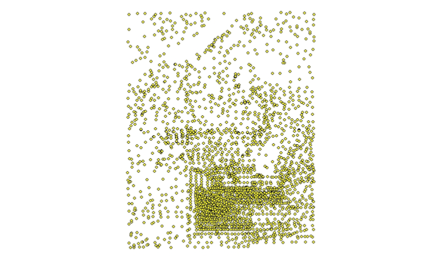
These data provide the locations of seabed sediment samples taken in the Stellwagen Bank National Marine Sanctuary region from 1993 to 2004. In addition to location information, the data also provides sediment analyses of each sample. See attribute section for complete description. The data for all of Stellwagen Bank is available as a shapefile.
Person who carried out this activity:
(508) 548-8700 x 2339 (voice)
(508) 457-2310 (FAX)
pvalentine@usgs.gov
Person who carried out this activity:
(508) 548-8700 x2314 (voice)
(508) 548-8700 x2314 (FAX)
lpoppe@usgs.gov
Person who carried out this activity:
(508) 548-8700 x2341 (voice)
(508) 457-2310 (FAX)
lgallea@usgs.gov
Person who carried out this activity:
(508) 548-8700 x2341 (voice)
(508) 457-2310 (FAX)
lgallea@usgs.gov
Blackwood, D., Parolski, K., and Valentine, P., 2000, Seabed Observation and Sampling System: U.S. Geological Survey Fact Sheet FS-142-00 FS-142-00, U.S. Geological Survey, Coastal and Marine Geology Program, Woods Hole Coastal and Marine Science Center, Woods Hole, MA.Online Links:
Poppe, L.J., Williams, S.J., and Paskevich, V.F., 2005, U.S. Geological Survey East-Coast Sediment Analysis: Procedures, Database, and GIS Data: U.S. Geological Survey Open-File Report 2005-1001 2005-1001, U.S. Geological Survey, Coastal and Marine Geology Program, Woods Hole Coastal and Marine Science Center, Woods Hole, MA.Online Links:
Page C. Valentine, editor, 2005, Sea floor image maps showing topography, sun-illuminated topography, backscatter intensity, ruggedness, slope, and the distribution of boulder ridges and bedrock outcrops in the Stellwagen Bank national marine Sanctuary region off Boston, Massachusetts: Scientific Investigations Map 2840, U.S. Geological Survey, Coastal and Marine Geology Program, Woods Hole Coastal and Marine Science Center, Woods Hole, MA.Online Links:
The seabed sediment sample locations were plotted in ArcMap 9.3 to ensure geographic location and station names were correct.
These data were navigated with a Differential Global Position System (DGPS); they are accurate to +/- 10 meters horizontally. During deployment, the camera system hangs directly below the side of the ship, and the recorded navigation data closely approximates the position of the camera system near the seabed. The ship is oriented so that wind and waves will not cause it to drift over the conducting cable attached to the SEABed Observation and Sampling System (SEABOSS).
Depth was acquired using the ship fathometer until 1998. After 1998 depth was acquired using the depth sensor on the SEABOSS. Depths are accurate to +/- 1 meter.
This shapefile has the locations for all seabed sediment samples taken between 1993 and 2004 on Stellwagen Bank as part of this project. We did not always collect photographs and video at stations where the purpose was just to collect sediment. All available grain-size data collected by the research cruises are included in this data set.
Data was sorted by station number to check for duplications. No other checks for topological consistency were preformed on this data.
Are there legal restrictions on access or use of the data?
- Access_Constraints: None
- Use_Constraints:
- Public domain data from the U.S. Government are freely redistributable with proper metadata and source attribution. Please recognize the U.S. Geological Survey (USGS) as the source of this information.
(508) 548-8700 x2339 (voice)
(508) 457-2310 (FAX)
pvalentine@usgs.gov
Downloadable Data
Neither the U.S. Government, the Department of the Interior, nor the USGS, nor any of their employees, contractors, or subcontractors, make any warranty, express or implied, nor assume any legal liability or responsibility for the accuracy, completeness, or usefulness of any information, apparatus, product, or process disclosed, nor represent that its use would not infringe on privately owned rights. The act of distribution shall not constitute any such warranty, and no responsibility is assumed by the USGS in the use of these data or related materials. Any use of trade, product, or firm names is for descriptive purposes only and does not imply endorsement by the U.S. Government.
| Data format: | Shapefile and associated metadata in format WinZip Size: 0.070 |
|---|---|
| Network links: |
<https://pubs.usgs.gov/ds/469/DataCatalog/sb_sedsamples.zip> <https://pubs.usgs.gov/ds/469/DataCatalog/sb_sedsamples.zip> |
These data are available in Environmental Systems Research Institute (ESRI) shapefile format. The user must have ArcGIS or ArcView 3.0 or greater software to read and process the data file. In lieu of ArcView or ArcGIS, the user may utilize another GIS application package capable of the importing data. A free data viewer, ArcExplorer, capable of displaying the data is available from ESRI at www.esri.com. The data is available to download in WinZip format that was created with WinZip Version 9.0 SR-1 (6224). An Excel file of the eighteen quadrangle's sediment analyses is included in the zip file.
(508) 548-8700 x2341 (voice)
(508) 457-2310 (FAX)
lgallea@usgs.gov