Data Series 541, version 1.0
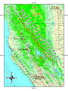
The purpose of this map is to show the location of and evidence for recent movement on active fault traces within the Bartlett Springs Fault Zone, California. The location and recency of the mapped traces is primarily based on geomorphic expression of the fault as interpreted from large-scale aerial photography. In a few places, evidence of fault creep and offset Holocene strata in trenches and natural exposures have confirmed the activity of some of these traces.
This publication is formatted both as a digital database for use within a geographic information system (GIS) and for broader public access as map images that may be browsed on-line or download a summary map. The report text describes the types of scientific observations used to make the map, gives references pertaining to the fault and the evidence of faulting, and provides guidance for use of and limitations of the map.
◊Click map [Browse the new mapping of the fault (1:100,000-scale)]
Persistent URL: https://pubs.usgs.gov/ds/541/ This online version of USGS DS-541 does not contain installers for associated software. You can get Adobe Reader and Flash Player (for Macintosh and Windows) using the links below: For questions about the content of this report, contact Jim Lienkaemper
U.S. Department of the Interior Download a copy of the latest version of Adobe Reader and Flash Player for free. |
Help
|
PDF
help | Publications
main page
| Department of the Interior | U.S. Geological Survey | Privacy Statement | Disclaimer | Accessibility | URL of this page: https://pubs.usgs.gov/ds/541/ Maintained by: Michael Diggles Created: December 21, 2010 Last modified: January 10, 2011 (mfd) |
|