Data Series 556
|
|
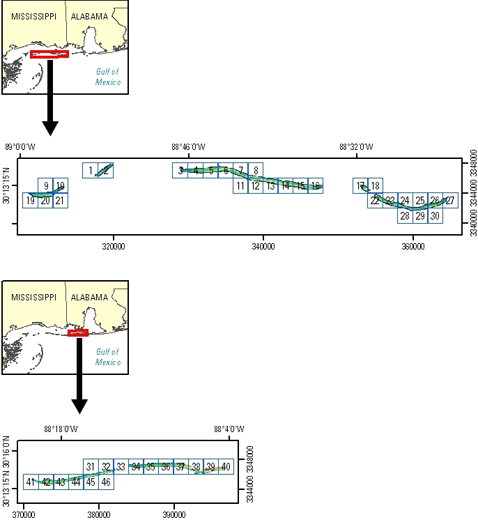
EAARL Coastal Topography–Mississippi and Alabama Barrier Islands, Post-Hurricane Gustav, 2008J.M. Bonisteel-Cormier,1 Amar Nayegandhi,1 C.W. Wright,2 A.H. Sallenger,2 J.C. Brock,3 D.B. Nagle,4 E.S. Klipp,1 Saisudha Vivekanandan,1 Xan Fredericks,1 and Martha Segura5 1Jacobs Technology Inc., St. Petersburg, FL; 2U.S. Geological Survey, St. Petersburg Coastal and Marine Science Center, St. Petersburg, FL; 3U.S. Geological Survey, Coastal and Marine Geology Program, Reston, VA; 4Jacobs Technology Inc., Reston, VA; 5National Park Service, Gulf Coast Network, Lafayette, LA. This DVD contains lidar-derived bare-earth (BE) and first-surface (FS) topography GIS datasets of a portion of the Mississippi and Alabama barrier islands. These datasets were acquired post-Hurricane Gustav on September 8, 2008. Click on a tile number (1 - 46) to view the corresponding images and links to each data directory.
Click on the links below to view mosaics of the data. Bare Earth (BE) 2.5-meter-resolution mosaic First Surface (FS) 2.5-meter-resolution mosaic Suggested Citation: Bonisteel-Cormier, J.M., Nayegandhi, Amar, Wright, C.W., Sallenger, A.H., Brock, J.C., Nagle, D.B., Klipp, E.S., Vivekanandan, Saisudha, Fredericks, Xan, and Segura, Martha, 2010, EAARL coastal topography–Mississippi and Alabama barrier islands, post-Hurricane Gustav, 2008: U.S. Geological Survey Data Series 556, 1 DVD. Publications are available from USGS Information Services, Box 25286, Federal Center, Denver, CO 80225-0046 (telephone: 1-888-ASK-USGS; email: [email protected]). |

![]() U.S. Department of the
Interior | U.S. Geological Survey
U.S. Department of the
Interior | U.S. Geological Survey
URL: pubsdata.usgs.gov
/pubs/ds/556/index.html
Page Contact Information:
Feedback
Page Last Modified: Monday, 28-Nov-2016 15:55:43 EST