U.S. Geological Survey Data Series 577
1Jacobs Technology Inc.,
2U.S. Geological Survey, St. Petersburg, FL 33701.
U.S. Department of the Interior
U.S. Geological Survey
Coastal and Marine Science Center - St. Petersburg
Publications are available from USGS Information Services, Box 25286, Federal Center, Denver, CO 80225-0046 (telephone 1-888-ASK-USGS; e-mail: infoservices@usgs.gov).
Table of Contents: |
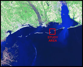
Figure 1. Mississippi Barrier Islands study area for USGS Cruise 10CCT02. |
||
This
This disc is readable on any computing platform that has standard DVD driver software installed. The minimum software requirements are a Web browser and Adobe Reader.
In March of 2010, the U.S. Geological Survey (USGS) conducted geophysical surveys offshore of Petit Bois Island, Mississippi, and Dauphin Island, Alabama (fig. 1). These efforts were part of the USGS Gulf of Mexico Science Coordination partnership with the U.S. Army Corps of Engineers (USACE) to assist the Mississippi Coastal Improvements Program (MsCIP) and the Northern Gulf of Mexico (NGOM) Ecosystem Change and Hazards Susceptibility Project by mapping the shallow geologic stratigraphic framework of the Mississippi Barrier Island Complex. These geophysical surveys will provide the data necessary for scientists to define, interpret, and provide baseline bathymetry and seafloor habitat for this area and to aid scientists in predicting future geomorphological changes of the islands with respect to climate change, storm impact, and sea-level rise. Furthermore, these data will provide information for barrier island restoration, particularly in Camille Cut, and protection for the historical Fort Massachusetts on Ship Island, Mississippi. For more information please refer to http://ngom.usgs.gov/gomsc/mscip/.
This report serves as an archive of the processed swath bathymetry and side scan sonar data (SSS). Data products herein include gridded and interpolated surfaces, seabed backscatter images, and ASCII x,y,z data products for both swath bathymetry and side scan sonar imagery. Additional files include trackline maps, navigation files, GIS files, Field Activity Collection System (FACS) logs, and formal FGDC metadata. Scanned images of the handwritten and digital FACS logs are also provided as PDF files. Refer to the Acronyms page for expansion of acronyms and abbreviations used in this report.
The USGS Center for Coastal and Marine Science - St. Petersburg assigns a unique identifier to each cruise or field activity. For example, 10CCT02 tells us the data were collected in 2010 for the Coastal Change and Transport (CCT) study and the data were collected during the second field (02) activity for that project in that calendar year. Refer to http://walrus.wr.usgs.gov/infobank/programs/html/definition/activity.html for a detailed description of the method used to assign the field activity ID.
Data were collected aboard the R/V Tommy Munro (http://www.usm.edu/gcrl/research_vessels/tommy.munro.php). Side scan sonar and interferometric swath bathymetry data were collected simultaneously along the navigational tracklines. The side scan sonar was towed off the port quarter of the vessel, generally within 3 m of the sea surface. The interferometric swath transducer was attached to the base of a rigid pole mount and deployed abeam to starboard side of the vessel. See the digital FACS equipment log for details about the acquisition equipment used. Both raw datasets were stored digitally and processed using CARIS HIPS and SIPS software at the USGS St. Petersburg Coastal and Marine Science Center. For more detailed information on processing, refer to the Equipment and Processing page. This survey was required to take place in the late winter months, in which strong winds and rough seas contributed to an overall reduction of data quality. The rough seas can be attributed to both the movement of the navigational and swath pole mount noise seen in the side scan sonar amplitude data. Chirp data were also collected during this survey and are archived separately.
To access the information contained on this disc, use a Web browser to open the file index.html. This report is divided into six sections: Navigation Data and Maps, Equipment and Processing, Images, Field Activity Logs, FGDC Metadata, and Software. Links at the top and bottom of each page provide access to these sections. This report also contains links to the USGS and collaborators or other resources that are accessible only if access to the internet is available while viewing these documents.
It was an effort to accomplish these works and we would not have been able to do so without the help and support of several partnering teams. The Framework Group (FRAWG) at the USGS St. Petersburg Coastal and Marine Science Center would like to thank the following for their efforts:
Funding for this project was provided by the Mississippi Coastal Improvements Program (MsCIP).
http://ngom.usgs.gov/gomsc/mscip/
The USGS Science Center – Seafloor Mapping Group, Woods Hole, MA: In particular, David C. Twichell, Elizabeth A. Pendelton, and William W. Danforth for their coordinated works with our surveying activities, and their continued expert technical consultations supporting the USGS St. Petersburg - FRAWG staff.
http://woodshole.er.usgs.gov/
Lijuan Huang and Gerald Hovis at NOAA/NOS/CO-OPS-HPT for their efforts to create the tidal zone definition for this work.
http://tidesandcurrents.noaa.gov/
Point Cadet Marina Harbor Masters: Jim Nations, Richard Johnson, and staff of the City of Biloxi, MS, for the use of their facilities and around the clock security provided in helping to protect Federal Government assets.
http://www.biloxi.ms.us/
Captain Paul Beaugez and crew of the R/V Tommy Munro: University of Southern Mississippi – Gulf Coast Research Laboratory, Point Cadet Marina, Biloxi, MS, for their hard work, flexibility, hospitality, and fine dining.
http://www.usm.edu/gcrl/research_vessels/tommy.munro.php
Karen Hart - Senior Hydrographic Consultant, CARIS USA, Alexandria, VA
http://www.caris.com
USGS St. Petersburg Coastal and Marine Science Center supporting staff:
Hayes, M.P., and Barclay, P.J., 2003, The effects of multipath on a bathymetric synthetic aperture sonar using belief propagation, in Bailey, D.G., ed., Proceedings of Image and Vision Computing New Zealand 2003, Novermber 26-28: Palmerston North, New Zealand, Massey University, 6 p.

![]() U.S. Department of the Interior |
U.S. Geological Survey
U.S. Department of the Interior |
U.S. Geological Survey
URL: https://pubsdata.usgs.gov/pubs/ds/577/index.html
Page Contact Information: William R. Pfeiffer
Page Last Modified: Monday, 28-Nov-2016 16:47:55 EST