USGS - science for a changing world

U.S. Geological Survey Data Series 652

Area A Map


Home | Acronyms | Contents | Navigation | Profiles | Logs | Metadata | Software


Click on a trackline name to view the geospatial profile image.

Area A Map sb_b3_a Geospatial Profile sb_b2b Geospatial Profile sb_a1_a Geospatial Profile sb_b5ns_a Geospatial Profile sb_b4a Geospatial Profile sb_b5_b Geospatial Profile sb6a_sgy Geospatial Profile sb_b7_a Geospatial Profile sb_b8a Geospatial Profile sb_b9_b Geospatial Profile sb_b12r_b Geospatial Profile sb_b10a Geospatial Profile sb_b11_a Geospatial Profile sb_b13_b Geospatial Profile t1_sb Geospatial Profile sb_b14a Geospatial Profile sb_b12a Geospatial Profile sb_b15_a Geospatial Profile sb_b16 Geospatial Profile sb_b17_b Geospatial Profile sb_b18a Geospatial Profile sb_d Geospatial Profile sb_b19 Geospatial Profile sb_b20 Geospatial Profile sb_b19a Geospatial Profile sb_b21_b Geospatial Profile sb_b22a Geospatial Profile sb_b23_b Geospatial Profile sb_b24_a Geospatial Profile sb_b25_a Geospatial Profile sb_b33_a Geospatial Profile sb_b32_a Geospatial Profile sb_b31_b Geospatial Profile sb_b29_a Geospatial Profile sb_b28_a Geospatial Profile sb_b27_b Geospatial Profile sb_b26_b Geospatial Profile sb_b4sn Geospatial Profile sb_b30a Geospatial Profile sb_b33_b Geospatial Profile sb_b32_b Geospatial Profile sb_b31_a Geospatial Profile sb_b30 Geospatial Profile sb_b29_b Geospatial Profile sb_b28_b Geospatial Profile sb_b27_a Geospatial Profile sb_b26_a Geospatial Profile sb_b24_b Geospatial Profile sb_b25_b Geospatial Profile sb_a3 Geospatial Profile sb_b23_a Geospatial Profile sb_b22b Geospatial Profile sb_b21_a Geospatial Profile sb20a_sy Geospatial Profile sb_b18b Geospatial Profile sb_b17_a Geospatial Profile sb_b5ns_b Geospatial Profile sb_a2 Geospatial Profile sb_a1_b Geospatial Profile sb_b15_b Geospatial Profile sb_b14b Geospatial Profile sb_b13_a Geospatial Profile sb_b12b Geospatial Profile sb_b12r_a Geospatial Profile sb_b11_b Geospatial Profile sb_b10b Geospatial Profile sb_b9_a Geospatial Profile sb_b8b Geospatial Profile sb_b7_b Geospatial Profile sb_b6 Geospatial Profile sb_b5_a Geospatial Profile sb_b4b Geospatial Profile sb_b3_b Geospatial Profile sb_b2a Geospatial Profile

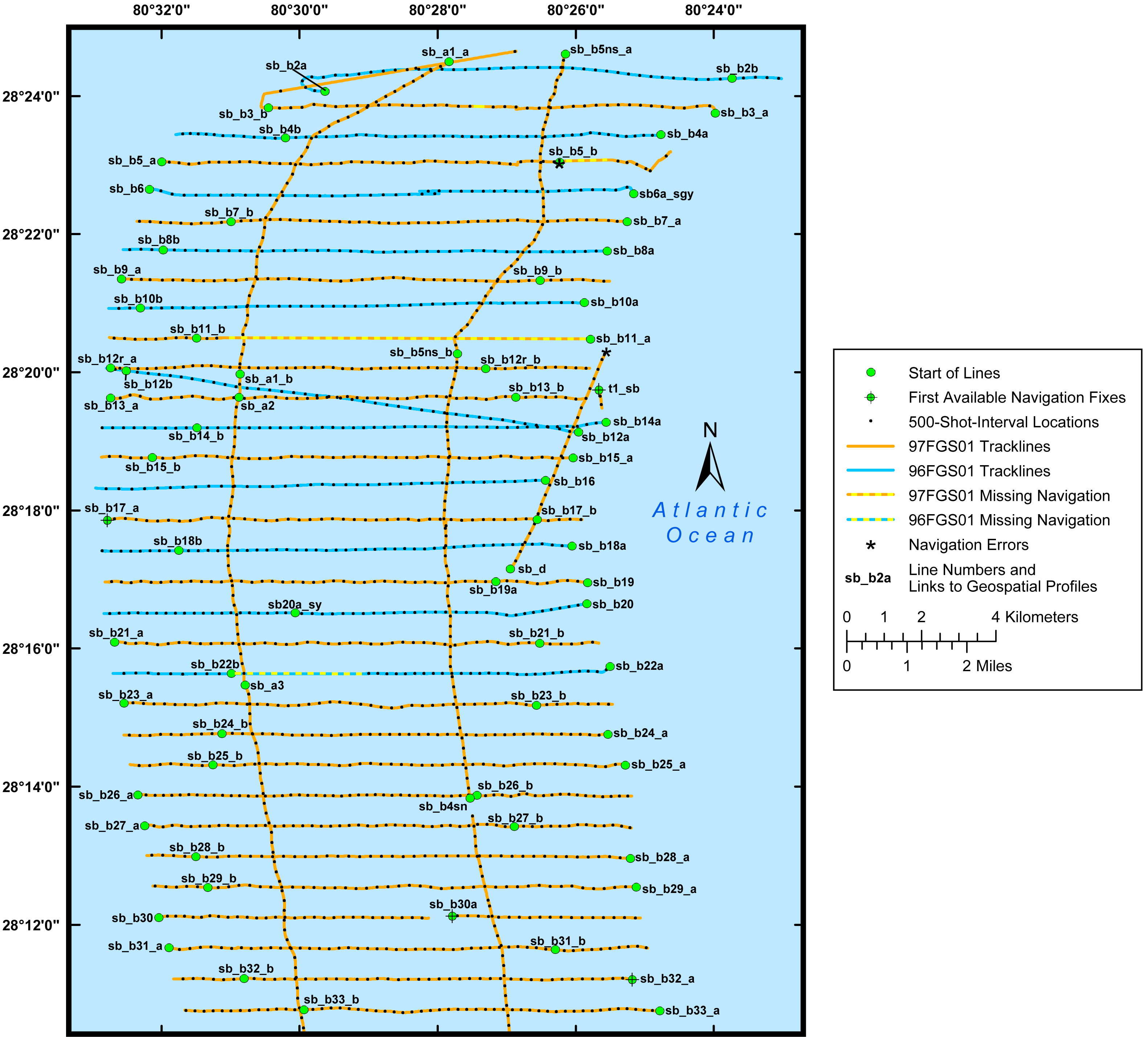
Figure 3. Trackline map of digital boomer seismic reflection data collected offshore of east-central Florida (refer to Area A on the location map) during USGS field activities 96FGS01 and 97FGS01.


Full Survey Area | Area A | Area B | Area C | Area D


Home | Acronyms | Contents | Navigation | Profiles | Logs | Metadata | Software

Accessibility FOIA Privacy Policies and Notices

Take Pride in America logo USA.gov logo U.S. Department of the Interior | U.S. Geological Survey
URL: http://pubsdata.usgs.gov/pubs/ds/652/html/area_a.html
Page Contact Information: GS Pubs Web Contact
Page Last Modified: Monday, 28-Nov-2016 18:55:20 EST