
DS710 - Active Traces of the Berryessa Fault
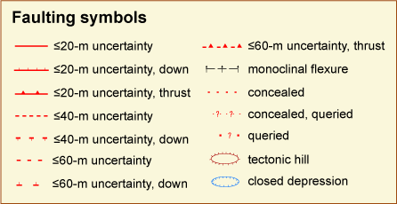
Symbols and Abbreviations
Three types of observations are often used to determine the location of the fault and indicate recency of movement: geomorphic evidence, creep evidence, and direct exposure of deformed geologic units either naturally exposed or in trenches. However, most of this fault zone lacks the cultural features needed to show the occurrence of creep, and as yet no trenches have been made across it . Therefore, the mapping of the active traces on this fault depends primarily on the interpretation of geomorphic features.
GEOMORPHIC FEATURES
Codes indicating strength of the evidence
G1 - strongly pronounced feature
G2 - distinct feature
G3 - weakly pronounced feature
? - additional
uncertainty in tectonic
origin
Codes
af - alignment
of multiple features as listed
as - arcuate scarp
bfs - Êback-facing scarp
bt - downthrown surface tilts back toward fault
dd - ÊÊdeflected drainage
df - depression
formed by some aspect of fault deformation, undifferentiated
dr - sag,
depression formed in right stepover
of
fault
trace
fs Ê- Êfaceted spur
gi - linear
break (or gradual inflection) in
slope
hb - Êlinear hillside bench
hv - linear hillside valley
ls - fault
scarp height enlarged by
landsliding
lv - linear valley or trough
n - notch
pr - pressure ridge in left stepover
rr - right-laterally offset ridge
line
rs - right-laterally
offset stream or gully
s Ê- ÊÊÊsaddle
sb - broad linear scarp (implies
multiple traces)
sc - scissor
point, sense of vertical
separation reverses
se - subsoil exposed
sl - linear
scarp, undifferentiated
sn - narrow linear scarp (implies
dominant trace)
sp - spring
ss - swale in saddle
vl - line of vegetation