Data Series 757
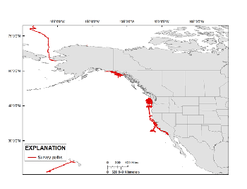
SummaryNew national programs, as well as natural and man-made disasters, have raised awareness about the need to find new and improved ways to share information about the coastal and marine environment with a wide-ranging public audience. The U.S. Geological Survey (USGS) Coastal and Marine Geology Program (CMGP) has begun a large-scale effort to incorporate the program's published, digital geophysical data into a single point of access known as the Coastal and Marine Geoscience Data System (CMGDS) (http://cmgds.marine.usgs.gov/). To aid in data discovery, work is also being done to import CMGP data into highly visible data and information resources, such as the National Oceanic and Atmospheric Administration's (NOAA) National Geophysical Data Center (NGDC) and two widely used Earth-science tools, GeoMapApp (GMA) (http://www.geomapapp.org) and Virtual Ocean (VO) (http://www.virtualocean.org/). This task of the CMGP Integrated Data Management System project will help support information exchange with partners, regional planning groups, and the public, as well as facilitate integrated spatial-data analysis. Sharing USGS-CMGP geophysical data via CMGDS, NGDC, GMA, and VO will aid data discovery and enable the data to support new purposes beyond those for which the data were originally intended. In order to make data available to NGDC, and from there into GMA and VO, the data must be reformatted into a standard exchange format and published. In 1977, a group of geophysical data managers from the public and private sectors developed the MGD77 format as the standard exchange format for geophysical data. In 2010, a tab-delimited version of the format was added as MGD77T (Hittelman and others, 1977). The MGD77T geophysical data format can include bathymetry, magnetics, gravity, and seismic navigation data. It is used for the transmission of data between marine institutions, data centers, and can be used by various software programs as an exchange format. A header (documentation) file and data file are created for each survey (Hittelman and others, 1977). More details about the MGD77T format are available at http://www.ngdc.noaa.gov/mgg/dat/geodas/docs/mgd77.pdf (74MB PDF). This archive describes the detailed steps used to convert single-beam bathymetry and navigation files into the MGD77T format (Hittelman and others, 1977) for submission to NGDC and formal Federal Geographic Data Committee (FGDC) (http://www.fgdc.gov/metadata) metadata as a publication of these single-beam bathymetry datasets. |
First posted March 20, 2013
For additional information contact: Part or all of this report is presented in Portable Document Format (PDF); the latest version of Adobe Reader or similar software is required to view it. Download the latest version of Adobe Reader, free of charge. |
Schreppel, H.A., Degnan, C.H, Dadisman, S.V., and Metzger, D.R., 2013, Archive of U.S. Geological Survey selected single-beam bathymetry datasets, 1969-2000: U.S. Geological Survey Data Series 757, available only at https://pubs.usgs.gov/ds/757.
Information Statements
Project Summary
Acknowledgments
References Cited

![]() U.S. Department of the Interior |
U.S. Geological Survey
U.S. Department of the Interior |
U.S. Geological Survey
URL: http://pubsdata.usgs.gov/pubs/ds/757/index.html
Page Contact Information: GS Pubs Web Contact
Page Last Modified: Monday, 28-Nov-2016 19:10:47 EST
