U.S. Geological Survey Data Series 757
By Heather A. Schreppel,1 Carolyn H. Degnan,2 Shawn V. Dadisman,2 and Dan R. Metzger3
1Cherokee Nation Technology Solutions
2U.S. Geological Survey
3National Geophysical Data Center, National Oceanic and Atmospheric Administration
U.S. Department of the Interior
U.S. Geological Survey
Publications are available from USGS Information Services, Box 25286, Federal Center, Denver, Colo. 80225-0046 (telephone 1-888-ASK-USGS; e-mail: infoservices@usgs.gov).
|
Page Contents: |
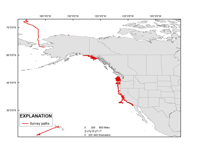 Figure 1. Map showing the geographic distribution of cruises in this archive, with the exception of P194AR. [larger version] |
This publication was prepared by an agency of the U.S. Government. Neither the U.S. Government nor any agency thereof nor any of their employees makes any warranty, expressed or implied, or assumes any legal liability or responsibility for the accuracy, completeness, or usefulness of any information, apparatus, product, or process disclosed in this report or represents that its use would not infringe privately owned rights. Reference therein to any specific commercial product, process, or service by trade name, trademark, manufacturer, or otherwise does not constitute or imply its endorsement, recommendation, or favoring by the U.S. Government or any agency thereof.
Although all data and software published in this publication have been used by the U.S. Geological Survey (USGS), no warranty, expressed or implied, is made by the USGS as to the accuracy of the data and related materials and (or) the functioning of the software. The act of distribution shall not constitute any such warranty, and no responsibility is assumed by the USGS in the use of these data, software, or related materials. These bathymetry data should not be used for navigational purposes.
New national programs, as well as natural and man-made disasters, have raised awareness about the need to find new and improved ways to share information about the coastal and marine environment with a wide-ranging public audience. The U.S. Geological Survey (USGS) Coastal and Marine Geology Program (CMGP) has begun a large-scale effort to incorporate the program's published, digital geophysical data into a single point of access known as the Coastal and Marine Geoscience Data System (CMGDS) (http://cmgds.marine.usgs.gov/). To aid in data discovery, work is also being done to import CMGP data into highly visible data and information resources, such as the National Oceanic and Atmospheric Administration's (NOAA) National Geophysical Data Center (NGDC) and two widely used Earth-science tools, GeoMapApp (GMA) (http://www.geomapapp.org) and Virtual Ocean (VO) (http://www.virtualocean.org/). This task of the CMGP Integrated Data Management System project will help support information exchange with partners, regional planning groups, and the public, as well as facilitate integrated spatial-data analysis. Sharing USGS-CMGP geophysical data via CMGDS, NGDC, GMA, and VO will aid data discovery and enable the data to support new purposes beyond those for which the data were originally intended.
In order to make data available to NGDC, and from there into GMA and VO, the data must be reformatted into a standard exchange format and published. In 1977, a group of geophysical data managers from the public and private sectors developed the MGD77 format as the standard exchange format for geophysical data. In 2010, a tab-delimited version of the format was added as MGD77T (Hittelman and others, 1977).
The MGD77T geophysical data format can include bathymetry, magnetics, gravity, and seismic navigation data. It is used for the transmission of data between marine institutions, data centers, and can be used by various software programs as an exchange format. A header (documentation) file and data file are created for each survey (Hittelman and others, 1977). More details about the MGD77T format are available at http://www.ngdc.noaa.gov/mgg/dat/geodas/docs/mgd77.pdf (74MB PDF).
This archive describes the detailed steps used to convert single-beam bathymetry and navigation files into the MGD77T format (Hittelman and others, 1977) for submission to NGDC and formal Federal Geographic Data Committee (FGDC) (http://www.fgdc.gov/metadata) metadata as a publication of these single-beam bathymetry datasets.
We thank Jon Childs, Dan Schierer, and Greg Miller for their guidance and contributions to the archiving process. We also thank Arnell Forde for her assistance in the preparation of this document. We would also like to give a special thanks to Mike Boyle for his historical operations insight. This document was also improved by the reviews of Jon Childs and Nancy Dewitt of the U.S. Geological Survey.
Brune, Robert, 1977, Background material for integrated marine navigation systems, marine gravimeters, and magnetometers/gradiometers: U.S. Geological Survey Open-File Report 77-648.
Carter, D. J.T., 1980, Echo-sounding correction tables (3d ed.): Hydrographic Department, Ministry of Defense, United Kingdom.
Duesser, R.E., Schwab, W.C., and Denny, J.F., 2002, The sea-floor mapping facility at the U.S. Geological Survey Woods Hole Field Center, Woods Hole, Massachusetts: U.S. Geological Survey Fact Sheet 039-02. (Also available at https://pubs.usgs.gov/fs/fs039-02/.)
Hittelman, A.M., Groman, R.C., Haworth, R.T., Holcombe, T.L., McHendrie, Graig, Smith, S.M., and Metzger, D.R., 1977, The marine geophysical data exchange format MGD77 / MGD77T: National Oceanic and Atmospheric Administration, National Geophysical Data Center, Boulder, Colo., 25 p. (Also available at http://www.ngdc.noaa.gov/mgg/dat/geodas/docs/mgd77.pdf [74KB PDF].)
Matthews, D.J., 1939, Tables of the velocity of sound in pure water and sea water for use in echo-sounding and sound-ranging (2d ed.): Hydrographic Department, Ministry of Defense, United Kingdom.
Steele, W.C., Degnan, C.H., Deeter, G.B., and Riordan, J.A., 1989, Description of marine geophysical data collected by the U.S. Geological Survey and how to obtain it: U.S. Geological Survey Open-File Report 89-167, 26 p. (Also available at https://pubs.usgs.gov/of/1989/0167/report.pdf [106 KB PDF].)
Telford, W.M., Geldart, L.P., and Sheriff, R.E., 1991, Applied geophysics: Cambridge, U.K., Cambridge University Press, p. 748.
U.S. Coast Guard, 1994, Specification of the transmitted Loran-C signal: Washington, D.C., Commandant Instruction M16562.4A.
U.S. Coast Guard, 2012, NDGPS frequently asked questions: U.S. Coast Guard Navigation Center, Alexandria, Va. http://www.navcen.uscg.gov/?pageName=dgpsFaq
Schreppel, H.A., Degnan, C.H, Dadisman, S.V., and Metzger, D.R., 2013, Archive of U.S. Geological Survey selected single-beam bathymetry datasets, 1969-2000: U.S. Geological Survey Data Series 757.

![]() U.S. Department of the Interior |
U.S. Geological Survey
U.S. Department of the Interior |
U.S. Geological Survey
URL:
Page Contact Information:
Page Last Modified:
