Data Series 935
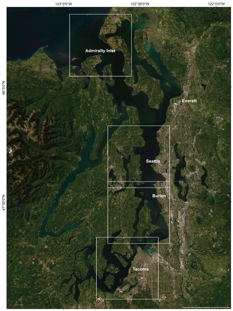
Figure 1. Locations of U.S. Geological Survey (USGS) map blocks (squares), of the Southern Salish Sea, Washington. Each to be published at 1:40,000 scale. Published map blocks are shown with bold border. SummaryIn 2010, the U.S. Environmental Protection Agency, Region 10 initiated the Puget Sound Scientific Studies and Technical Investigations Assistance Program, which was designed to support research for implementing the Puget Sound Action Agenda. The Action Agenda was created because Puget Sound was designated as one of 28 estuaries of National Significance under section 320 of the Clean Water Act, and its overall goal is to restore the environment of the Puget Sound Estuary by 2020. The Southern Salish Sea Mapping Project was funded through the Assistance Program request for proposal process which also supports a large number of coastal-zone- and ocean-management issues, and includes the recommendations of the Marine Protected Areas Work Group to the Washington State Legislature. These recommendations include a Puget Sound and coast-wide marine conservation needs assessment, gap analysis of existing Marine Protected Areas and recommendations for action. Four areas with recently acquired National Ocean Service hydrographic data are included in the Southern Salish Sea Habitat Map Series (fig. 1), each to be published individually as USGS Open File Reports at a scale of 1:40,000. The map products display seafloor geoforms, substrate, and biotopes using the Coastal and Marine Ecological Classification Standard. This data catalog contains much of the data used to prepare the SIMs in the Southern Salish Sea Habitat Map Series. Other data that were used to prepare the maps were compiled from previously published sources (for example, sediment samples and seismic reflection profiles) and are not included in this data series. AcknowledgmentsDatasets within the data catalog have been compiled by various individuals (names are provided in the metadata for each dataset). GIS DataFor each map block, USGS has created geographic information system (GIS) data layers for bathymetry, bathymetric hillshade, observations of habitat and biota in video, and CMECS geoform, substrate and biotopes. GIS Data Layers:
Data Catalogs:Each data catalog lists the available GIS data layers with a brief description, a small TIFF image, and hyperlinks to the metadata files and the downloadable data files. Information on file format and file size also are provided. The data were compiled in ArcMap (versions 10.0 and 10.1, ESRI, 2011, 2012). Raster data layers are registered TIFF images and are in either the UTM Zone 10 or UTM Zone 11 coordinate systems, with datum NAD83. Point, line, and polygon features are in shapefile format and are projected in UTM Zone 10 coordinates, with horizontal datum NAD83. The downloadable data files have been compressed with the "zip" command, and can be unzipped with Winzip (or other tool) on Windows systems. The .zip file for a TIFF image includes the image (.tif), the world registration file (.tfw), and the text (.txt) and XML (.tif.xml) versions of the metadata. For best results, create a single new folder to save the zipped files, and then unzip the files you want to use.
|
First posted June 2, 2015 For additional information, contact: |
Cochrane, G.R., compiler, 2014, Southern Salish Sea Habitat Map Series Data Catalog: U.S. Geological Survey Data Series 935, https://dx.doi.org/10.3133/ds935
ISSN 2327-638X (online)

![]() U.S. Department of the Interior |
U.S. Geological Survey
U.S. Department of the Interior |
U.S. Geological Survey
URL: http://pubsdata.usgs.gov/pubs/ds/935/index.html
Page Contact Information: GS Pubs Web Contact
Page Last Modified: Monday, 24-Apr-2023 14:13:25 EDT
