
![]()
| To PREVIOUS
Page |
To Contents To Title Page | To NEXT Page |
| Estimated
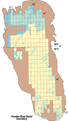
Resources of Non-Leased Federal Coal, Powder River Basin Montana and Wyoming From V. A. Trent, 1986, USGS Map MF-1887 |
||
| Maps are generated by combining digital ownership data with geologic resource estimates and other spatial coal data in a geographic information system (GIS). For example, we merged the newly compiled Federal coal ownership files with resource calculations from the 1970's for the Powder River Basin (Trent, 1986). For the first time, we are able to visually display the location of Federally owned coal in each 7.5' quadrangle along with the published coal resource estimates for those areas (fig. 8). | ||
| Please click (or double click) in quadrangles of the interactive, (largest) map for details and Publication Sources on Estimated coal resources |
 |
  |
|
 |
![]()
| To
PREVIOUS
Page |
To Contents To Title Page | T o NEXT Page |
| U. S.
Department of the Interior U. S. Geological Survey |
USGS
Fact Sheet FS-012-98 February 1998 |