
![]()
| To PREVIOUS Page To Contents | To Title Page
To NEXT Page |
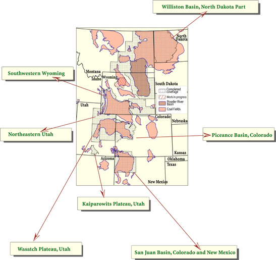
| Figure 7 shows areas where digital compilation of coal ownership data is completed or well underway. With the exception of the Kaiparowits Plateau, Utah, a large part of which was recently designated a National Monument, the detailed maps represent areas where coal is, has been, or likely will be produced in the Western United States. These coal ownership data become the basis for complex spatial analyses when combined with information on coal quality, coal thickness, structure, and other parameters generated from geologic investigations. | |
![]()
Below is an example of the directory structure used by the USGS Energy
Resources Program's Federal Lands Assessment project to catalog and archive
the many files and ARC/INFO coverages generated by the project. Top-level
directories contain work areas arranged by USGS energy resource regions.
Subdirectories include metadata documents that describe the data sources
and processing history for each coverage and files with information on
map projection parameters. Scale and resolution of the data are important
factors in the arrangement of the hierarchy of a spatial data repository
and identify the level of detail and accuracy of the data. Names given
to directories and files are designed to be intuitive and describe the
basic contents of the file. 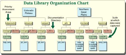 |
| To PREVIOUS Page To Contents | To Title Page To NEXT Page |
| U. S.
Department of the Interior U. S. Geological Survey |
USGS
Fact Sheet FS-012-98 February 1998 |