
| Most loss of life and property in earthquakes is the result of damage to or collapse of buildings or other structures from strong shaking. Key to reducing such losses are recordings of structural response to damaging levels of shaking. Using these recordings, engineers can better design new buildings and strengthen existing buildings to survive future quakes. The U.S. Geological Survey (USGS) and cooperators are engaged in a national effort to acquire these critically needed strong-motion measurements in earthquake-prone urban areas. |
 |
|
 |
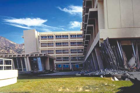
The 1971 San Fernando, California, earthquake (magnitude 6.7) severely damaged the recently built Olive View Hospital. This building was not instrumented with seismic sensors. Accordingly, no data were obtained to understand how the damage initiated and progressed during the intense shaking. The building was razed and replaced with a stronger structure that survived the 1994 Northridge earthquake. |
Strong earthquake shaking
can damage vulnerable buildings, dams, and other structures, causing catastrophic
loss of life and property in densely urbanized areas. For example, the 1994
Northridge, California, earthquake (magnitude 6.7) caused more than $20 billion
in structural damage and killed 57 people in the greater Los Angeles region.
Reducing such losses requires measurements of structural response to strong
levels of earthquake shaking in structures likely to be damaged.
Under the National Earthquake Hazards Reduction Program enacted by Congress in 1977, the U.S. Geological Survey (USGS) has responsibility for the Federal effort to acquire strong-motion measurements in structures throughout the United States. Engineers need these critical measurements so that they can better design new structures to survive future quakes. In pursuit of this goal, the USGS cooperates with other structural monitoring programs, such as those of the California Geological Survey, Army Corps of Engineers, General Services Administration, and University of Puerto Rico, Mayagüez.
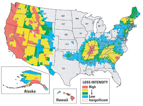 |
| Future earthquake losses are estimated to be largest in urban areas, not only in the western United States, but also in Alaska, Hawaii, South Carolina, and the central and northeastern parts of the Nation. This map from the Federal Emergency Management Agency depicts the distribution, by county, of estimated long-term average annual earthquake losses as a fraction of the replacement value of the building inventory. By placing shaking sensors in buildings in quake-prone regions of the country, the U.S. Geological Survey and cooperators are acquiring data critical for reducing future losses arising from structural damage and collapse. |
Few buildings in urban areas threatened by damaging earthquakes are currently equipped with seismic sensors. However, recordings from such sensors are critical to designing safer buildings and preventing loss of life by:
• Understanding how damage from strong shaking occurs,Although progress has been limited by the lack of shaking records from buildings damaged during strong earthquakes, records from buildings obtained to date have enabled progress on all of these fronts:
Understanding how damage occurs—Only a few records of shaking have been obtained in buildings seriously damaged by an earthquake. Such records are needed to document and understand how damage begins and progresses during intense seismic shaking. They are crucial to reducing or avoiding future quake losses. For example, during the 1994 Northridge earthquake, numerous steel-frame buildings were unexpectedly damaged, but only two damaged, steel-frame buildings in the region had been instrumented with shaking sensors. In the shaken urban area, about 300 steel-frame buildings that did not have shaking sensors were investigated for damage—a long and costly process. Having recorders in many of these buildings would have yielded invaluable information on (1) what types of buildings suffered damage to their steel frames, (2) why such damage occurred, and (3) what might be solutions for repair and strengthening of the damaged structures.
Improving earthquake resistance—Large losses from earthquakes striking major urban areas in quake-conscious California and Japan during the past two decades have prompted new approaches to building earthquake resistant structures. One new strategy for safeguarding a building is partially “decoupling” the building from the ground at its base, thereby reducing the earthquake forces acting on the structure. The potential payoff from such a protective strategy, known as base isolation, can be evaluated by recording earthquake motion in the structure above the isolators as well as in the ground beneath them and then comparing the shaking level in the building to that in a similar structure with a conventional foundation.
Upgrading building codes—Monitored structures provide essential data for confirming and (or) improving building-code provisions and design procedures. Response data from structures subjected to design-level shaking allow comparison of actual building behavior and performance to those anticipated and intended by design codes and procedures. Significant differences between what is expected and what actually is measured prompts new code provisions and design practices, or revisions to them, so that future building designs and remedial strengthening better withstand strong shaking. The upgrading of codes and practices is a deliberative, continuous process. Two examples of advances spurred by response data are (1) increasing the flexural restraint of large-span floors and roofs and (2) incorporating the dynamic interaction of a building foundation with the surrounding soil in calculation of the building performance in a strong design earthquake.
Assessing building safety—As design procedures and analysis tools improve, earthquake engineers and building owners are embracing performance-based design. Structures are being designed for specific quake-performance levels chosen by owners and engineers, such as allowable level of damage. This design strategy implies knowledge of the deformation of the overall structure during an earthquake, as well as of its component elements. Such knowledge requires measurement of the motion at several heights within the structure to determine its deformation. When the deformation exceeds a prescribed threshold value, the building manager can gauge the health and safety of the structure and initiate an appropriate response.
To improve and modernize seismic monitoring in the United States, particularly in high-risk seismic regions, Congress in 2000 authorized the Advanced National Seismic System (ANSS). The ANSS plan, now being implemented by the USGS and cooperators, envisions 3,000 new sensors placed in urban structures to monitor their response to strong earthquakes, in addition to 3,000 new ground sensors. Placing sensors in many more buildings in active seismic regions will further hasten efforts to better safeguard buildings and their occupants and contents against damage and loss in future earthquakes.
Other sections of this fact sheet:
COOPERATING
ORGANIZATIONS
California Geological Survey
California Department of Transportation
California Institute of Technology
California State University, Northridge
City of Los Angeles
Consortium of Organizations for Strong-Motion
Observation Systems
Federal Deposit Insurance Corporation
Federal Highway Administration
General Services Administration
Jet Propulsion Laboratory, NASA
Metropolitan Water District of Southern California
Missouri Department of Transportation
Oregon Department of Highways
Pacific Gas and Electric Company
U.S. Army Corps of Engineers
U.S. Bureau of Reclamation
U.S. Department of Veteran Affairs
University of Alaska
University of California, Los Angeles
University of Memphis
University of Puerto Rico, Mayagüez
Washington Department of Highways
Washington Department of Natural Resources
Many city and county agencies and private building owners
For questions about the content of this report, contact Mehmet Çelebi
PDF version of this fact sheet (1.8 MB)
Download a current version of Acrobat Reader for free
| Help
| PDF help
| Geopubs main page | Fact
Sheets |
| Geologic
Division | Earthquake Hazards Program
|