Fact Sheet 2009-3025
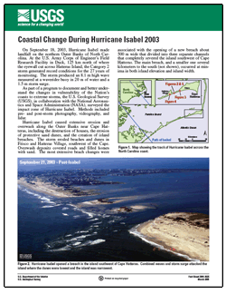
On September 18, 2003, Hurricane Isabel made landfall on the northern Outer Banks of North Carolina. At the U.S. Army Corps of Engineer’s Field Research Facility in Duck, 125 km north of where the eyewall cut across Hatteras Island, the Category 2 storm generated record conditions for the 27 years of monitoring. The storm produced an 8.1 m high wave measured at a waverider buoy in 20 m of water and a 1.5 m storm surge. As part of a program to document and better understand the changes in vulnerability of the Nation’s coasts to extreme storms, the U.S. Geological Survey (USGS), in collaboration with the National Aeronautics and Space Administration (NASA), surveyed the impact zone of Hurricane Isabel. Methods included pre- and post-storm photography, videography, and lidar. Hurricane Isabel caused extensive erosion and overwash along the Outer Banks near Cape Hatteras, including the destruction of houses, the erosion of protective sand dunes, and the creation of island breaches. The storm eroded beaches and dunes in Frisco and Hatteras Village, southwest of the Cape. Overwash deposits covered roads and filled homes with sand. The most extensive beach changes were associated with the opening of a new breach about 500 m wide that divided into three separate channels that completely severed the island southwest of Cape Hatteras. The main breach, and a smaller one several kilometers to the south (not shown), occurred at minima in both island elevation and island width. |
Posted April 7, 2009
Part or all of this report is presented in Portable Document Format (PDF); the latest version of Adobe Reader or similar software is required to view it. Download the latest version of Adobe Reader, free of charge. |
Morgan, K.L.M., 2009, Coastal Change During Hurricane Isabel 2003: U.S. Geological Survey Fact Sheet 2009–3025, 2 p.

![]() U.S. Department of the Interior |
U.S. Geological Survey
U.S. Department of the Interior |
U.S. Geological Survey
URL: https://pubsdata.usgs.gov/pubs/fs/2009/3025/
Page Contact Information: Contact USGS
Page Last Modified: Tuesday, 29-Nov-2016 17:32:03 EST
