Fact Sheet 2010–3075
1U.S. Geological Survey
2Teton Conservation District
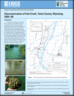
Fish Creek, a tributary to the Snake River, is about 15 river miles long and is located in Teton County in western Wyoming near the town of Wilson (fig. 1). Public concern about nuisance growths of aquatic plants in Fish Creek has been increasing since the early 2000s. To address this concern, the U.S. Geological Survey, in cooperation with the Teton Conservation District, began studying Fish Creek in 2004 to describe the hydrology of the creek and later (2007–08) to characterize the water quality and the biological communities. The purpose of this fact sheet is to summarize the study results from 2004 to 2008. |
First posted September 15, 2010 For additional information contact: Part or all of this report is presented in Portable Document Format (PDF); the latest version of Adobe Reader or similar software is required to view it. Download the latest version of Adobe Reader, free of charge. |
Eddy-Miller, C.E., Petersen, D.A., Wheeler, J.D., and Leemon, D.J., 2010, Characterization of Fish Creek, Teton County, Wyoming, 2004–08: U.S. Geological Survey Fact Sheet 2010–3075, 4 p.

![]() U.S. Department of the Interior | U.S. Geological Survey
U.S. Department of the Interior | U.S. Geological Survey
URL: http://pubsdata.usgs.gov/pubs/fs/2010/3075/index.html
Questions or Assistance: Contact USGS
Last modified: Tuesday, 29-Nov-2016 17:41:03 EST
