(Larger Version, 194K GIF)

Vast amounts of spatial and temporal data are currently being collected and compiled by the U.S. Geological Survey (USGS) and other State and Federal agencies in support of the ecosystem restoration efforts in South Florida. Spatial data that are being "mapped" include vegetation characteristics, aquifer properties, soil conditions and types, land-surface elevations, physical features, and embayment bathymetry. Temporal data depicting seasonal changes in the distribution and abundance of species, constituent concentrations, water levels, wetland flows, and canal discharges, as well as meteorological data, such as precipitation, wind speed and direction, temperature, and solar radiation, are also being collected. A GIS-based tool has been developed within the USGS and is being used to assimilate, interpret and analyze the spatial and temporal data in support of the development of hydrologic, hydrodynamic/transport, and ecological models of the South Florida ecosystem.
|
(Larger Version, 194K GIF) |
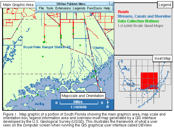
| Figure 1. Map graphic of a portion of South Florida showing the main graphics area, map scale and orientation box, legend information area and overview inset map generated by a GIS interface developed by the U.S. Geological Survey (USGS). This illustrates the framework of what a user sees on the computer screen when running the GIS graphical user interface called DBView. |
The objective of this project has been to develop a user-friendly, interactive GUI to enable scientists to easily and readily analyze and assess comprehensive data that describe complex environmental systems, such as the South Florida ecosystem. The GUI described here provides a GIS interface to comprehensive databases that anyone can use, and allows a user to browse and manipulate with ease their own spatial data, called "coverages", as well as, coverages that have been compiled by others. This GIS database viewing tool, called DBView, uses ARC/INFO's1 Arc Macro Language (AML) to maintain computer hardware and operating system portability with many computer platforms. DBView consists of a number of general-purpose GIS tools that offer an intuitive means for assessing GIS databases, and can display and identify mapped features and their attributes. DBView is a GIS interface that provides a fast, yet powerful means-of-access to a variety of environmental databases, such as those maintained for the South Florida ecosystem by the Everglades National Park, the South Florida Water Management District, and other State and Federal agencies. Although DBView is proving to be useful in conducting the South Florida ecosystem investigation as illustrated herein, it is a portable generic tool that also can be useful in other environmental studies.
1Use of this product name is for descriptive purposes only and does not imply endorsement by the U.S. Government.
Spatial Data Characteristics
DBView features the ability to use spatial coverages that are in vector, raster, and image formats. Vector coverages represent features as points, lines and areas, such as the USGS digital line graphs (DLG) map products. Raster format pertains to data represented in rows and columns of cells that make up a rectangular grid of values. Each cell contains attributes about the geographic area that it represents, such as elevations in USGS digital elevation model (DEM) grids. Image data include digital satellite photographs or map products such as USGS digital orthophoto quadrangles (DOQ) and digital raster graphics (DRG).
Interface Framework
Spatial data are displayed by DBView in a map graphics framework (fig. 1) that consists of a main map-graphic area, map scale and orientation box, overview inset map, and a legend information area. The map scale and orientation box, which consists of a scale bar and a north arrow, and the inset map are recalculated to correspond to the geographic area currently being displayed. The legend information is also updated to always reflect the map-information layers selected by the user. The USGS 1:100,000-scale DLG layers (hydrography in blue and transportation in red) for a portion of South Florida are illustrated in the main graphic area of figure 1. Also displayed are data-collection stations (green dots) and 1:24,000-scale topographic quadrangle map boundaries (dark gray dashed lines). Quadrangle names are indicated in blue text.
Defining the Geographic Area
The Pan/Zoom options, included on the main pulldown menu bar, offer the user a number of ways to define and display a geographic area of particular interest. Zoom-in options permit the user to magnify an area of interest by 1) defining a rectangle on the screen using the mouse, 2) keying in latitude/longitude coordinates, 3) specifying cover features, 4) identifying a particular 1:24,000-scale topographic quadrangle map, and 5) selecting data-collection sites. Three pre-defined zoom-out options enlarge both x and y dimensions of the currently displayed region by 10, 30, or 80 thousand meters or feet, depending on the units of the map projection. A fourth zoom-out option allows the user to specify the enlarging dimensions using units of their choice of feet, meters, or miles. The Pan option provides the ability to display the region adjacent to the one currently displayed. A Previous option permits the user to re-display the area that was previously displayed. This enables the user to readily zoom in and then zoom back to the original area with ease.
DBView Tools and Extensions
DBView consists of several general purpose tools and extensions that automate specific GIS functions to help users compile, analyze, and interpret their data. These tools allow the user to find, display, and identify mapped features by listing their attributes. Most menu tools within DBView contain a Help option that briefly describes how to use the menu and what the tool expects as input. The Tools and Extensions options, also located on the main pulldown menu bar, contain the following:
Identify Menu - provides the capability to point and click on a displayed map feature and have DBView present the feature's attributes in either a popup window or as annotation in the map-graphic area, depending on the identification presentation option (List or Annotate) selected by the user.
Select Sites - contains a number of options that provide the capability to select data-collection sites that meet user-specified criteria. DBView will highlight and display sites that meet a user's criteria -- for instance, sites that are in a specified area and at which desired parameters were collected during a specified time period. The functional capability to access the actual temporal data that are associated with the selected sites is currently being developed. (For the South Florida Ecosystem Program, the temporal database is currently under development and will be maintained by the USGS office in Miami, Fla. DBView will provide users remote access to this database.)
 (Larger Version, 197K GIF) |
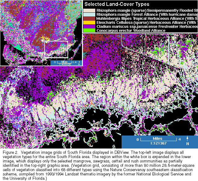
| Figure 2. Vegetation image grids of South Florida displayed in DBView. The top-left image displays all vegetation types for the entire South Florida area. The region within the white box is expanded in the lower image, which displays only the selected mangrove, sawgrass, cattail and rush communities as partially identified in the top-right graphic area. (Vegetation grid, consisting of more than 80 million 28.5-meter-square cells of vegetation classified into 68 different types using the Nature Conservancy southeastern classification scheme, compiled from 1993/1994 Landsat thematic imagery by the former National Biological Service and the University of Florida.) |
Select Land-Cover Types - provides the capability to specify land-cover types to be displayed. Once the land-cover types have been specified, DBView will calculate a statistical summary identifying the number of acres, square meters or square miles, and percent of each selected land-cover type. This summary information is presented to the user in a popup window. This tool can be used, for instance, with the vegetation map of the South Florida region (fig. 2) and with other USGS products such as the 1:250,000-scale land-use digital data.
 (Larger Version, 194K GIF) |
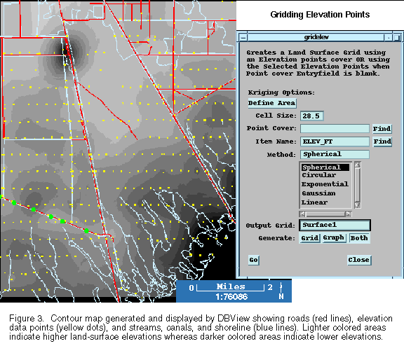
| Figure 3. Contour map generated and displayed by DBView showing roads (red lines), elevation data points (yellow dots), and streams, canals, and shoreline (blue lines). Lighter colored areas indicate higher land-surface elevations whereas darker colored areas indicate lower elevations. |
For more information, please contact:
David W. Stewart
450 National Center
Reston, Va. 22192
(703) 648-4879
dwstewar@usgs.gov
http://sflwww.er.usgs.gov
This fact sheet is also available in pdf format:
![]() fs-193-97.pdf K
fs-193-97.pdf K
http://water.usgs.gov/lookup/get?fs19397
Web version by: Genevieve Comfort
Last Modified: 14MAY 1998