|
Factors controlling ground shaking |
| In addition to earthquake recurrence, hazard also depends on how amplitudes of earthquake waves die out as they
move away from the earthquake source to the affected site. It is well known that wave energy decreases much more slowly
in the Central and Eastern United States than in the West. For the same size earthquake, this leads to greater shaking over
larger areas, or higher hazard, in the Central and Eastern United States. Earthquake shaking also may be significantly
amplified or damped by the soils immediately beneath a site. This is particularly true for thick sediments that underlie
most of the New Madrid seismic zone. Recent research has highlighted the potential amplification of ground shaking
by these thick sediments and has begun to shed light on the physical processes that cause this. Because characterization
of this amplification |
|
|
requires detailed mapping of the soils and their properties, amplification characteristics are not included in the National
Seismic Hazard Maps. Efforts are underway, however, to produce complementary maps that do show these amplification
characteristics on scales appropriate for use in urban planning, earthquake hazard mitigation, and response planning efforts. |
|
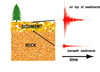
When waves of a small earthquake impinge on the boundary between hard
rock and overlying sediments from below (lower seismogram), they become
amplified as they travel through the sediments to the surface (upper seismogram).
A seismogram records the wave motion over time. The amplifying effects
of thick sediments above the New Madrid seismic zone results in motions at the
surface that are many times larger than below. (Courtesy of C. Langston, The
University of Memphis.) |
|
| For more information
contact: |
Joan Gomberg
Eugene Schweig
U.S. Geological Survey
3876 Central Avenue
Suite 2
Memphis, TN 38152-3050
901-678-4858
[email protected] |
| Web graphic design
and layout by Pamela Svendsen Detra and Tracy Roudebush |
|