U.S. Geological Survey
USGS BACK
Page 2
NEXT
Page 4
Index Page Geology Search USGS

Geologic Hazards Fact Sheet

Earthquake Hazard in the Heart of the Homeland

U.S. Geological Survey FS-131-02 Page 3

level of hazard. Additionally, the large earthquakes in the New Madrid region seem to happen much more frequently than predicted from extremely accurate satellite-based measurements of ground deformation. These measurements show that the Earth’s crust is being deformed, or strained, extremely slowly, if at all. This is in contrast to California, where the rate of major earthquakes is predictable based on measured deformation.

Far from a plate boundary
Why does the Central United States have more large earthquakes than expected? Why is it so different from California? The answers to these questions are still unknown, but scientists now question whether there might be fundamental differences between the geologic processes at, and away from, plate boundaries. The New Madrid region is far away from any

tectonic plate boundary, and thus applying what has been learned from studies of places like the San Andreas system in California to the New Madrid region may not be appropriate.

Shaded topographic relief map showing the New madrid seismic zone

On this shaded topographic relief map, the New Madrid seismic zone is shown by a star, and the boundaries of the North American and surrounding plates are indicated by red lines. Mountainous regions tend to occur near plate boundaries, resulting from the motions between plates. The nearest plate boundary to the New Madrid seismic zone is many thousands of kilometers away.

Digging up the past
To figure out the earthquake hazard of an area, scientists need to know how often the largest earthquakes occur. Unfortunately (from a scientific perspective), the time between major earthquakes is much longer than the time period for which we have modern instrumental measurements or even historical accounts of earthquakes. Fortunately, scientists have found a sufficiently long record of past earthquakes that is preserved in the rock and soil beneath our feet. The unraveling of this record is the realm of a field called “paleoseismology.” In 
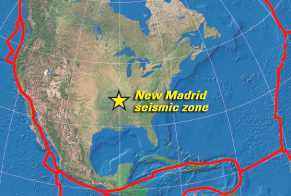
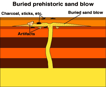
the Central United States, abundant sand blows are studied by paleoseismologists. These patches of sand erupt onto the ground when waves from a large earthquake pass through wet, loose sand. The water pressure increases, forcing the sand grains
Buried prehistoric sand blow showing charcoal, sticks, artifacts, etc.
Modern sand blow showing silt and clay layers, sand dike, liquified sand and earthquake waves
apart until the sand starts to behave like a liquid (“liquefies”), and a slurry of sand and water is forced to the ground surface. If the age of material buried by the erupted sand can be determined (such as Native American artifacts or plant remains), then we know the earthquake must have occurred after this date. If the sand blow is itself buried by something that can be dated, then we know the earthquake happened before this date. We now know that series of large earthquakes, similar in size and location to those in 1811-1812, have occurred twice in the past 1,200 years, once between A.D. 800 and 1000, and again between A.D. 1300 and 1600, or about one every 500 years.
USGS BACK
Page 2
NEXT
Page 4
Index Page Geology Search USGS