U.S. GEOLOGICAL SURVEY
Fact Sheet 045-03
Honolulu, Hawaii 2003
Figures are in pdf format. Download Adobe reader for free.
Surface water in Hawaii is a valued resource as well as a potential threat to human lives and property. The surface-water resources of Hawaii are of significant economic, ecologic, cultural, and aesthetic importance. Streams supply more than 50 percent of the irrigation water in Hawaii, and although streams supply only a few percent of the drinking water statewide, surface water is the main source of drinking water in some places. Streams also are a source of hydroelectric power, provide important riparian and instream habitats for many unique native species, support traditional and customary Hawaiian gathering rights and the practice of taro cultivation, and possess valued aesthetic qualities. Streams affect the physical, chemical, and aesthetic quality of receiving waters, such as estuaries, bays, and nearshore waters, which are critical to the tourism-based economy of the islands.
Streams in Hawaii pose a danger because of their flashy nature; a stream's stage, or water level, can rise several feet in less than an hour during periods of intense rainfall. Streams in Hawaii are flashy because rainfall is intense, drainage basins are small, basins and streams are steep, and channel storage is limited. Streamflow generated during periods of heavy rainfall has led to loss of property and human lives in Hawaii.
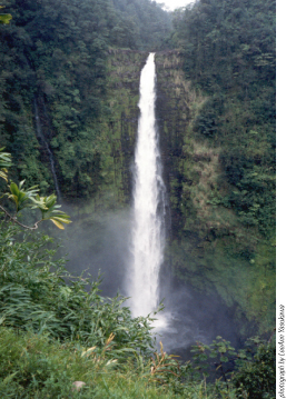
Most Hawaiian streams originate in the mountainous interiors of the islands and terminate at the coast. Streams are significant sculptors of the Hawaiian landscape because of the erosive power of the water they convey. In geologically young areas, such as much of the southern part of the island of Hawaii, well-defined stream channels have not developed because the permeability of the surface rocks generally is so high that rainfall infiltrates before flowing for significant distances on the surface. In geologically older areas that have received significant rainfall, streams and mass wasting have carved out large valleys.
Streamflow consists of (1) direct runoff of rainfall, in the form of overland flow and subsurface storm flow that rapidly returns infiltrated water to the stream, (2) ground-water discharge, in the form of base flow, where the stream intersects the water table, (3) water returned from bank storage, (4) rain that falls directly on streams, and (5) any additional water, including excess irrigation water, discharged to the stream by humans. The amount of direct runoff and base flow that contributes to total streamflow is dependent on factors including rainfall amount and intensity, drainage-basin geology, morphology, and size, soils, and land cover. Streamflow characteristics also can be affected by humans through diversions, channelization, dams, land-use changes, and other factors.
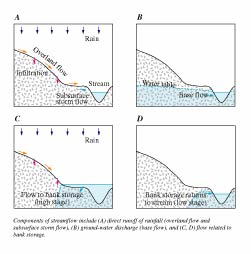
Direct runoff occurs during and immediately following a period of rainfall and may be produced by several processes. When the capacity of the soil to accept water (infiltration capacity) and the capacity of the surface depressions to store water are exceeded, water begins to run off in a sheet of overland flow. During a storm, overland flow may be generated over only parts of a basin. In urban areas, overland flow occurs commonly on paved surfaces. Rain that falls on saturated soils, where the ground-water table is at the land surface or rises to the land surface during a storm, runs off as saturation overland flow.
Rainfall that infiltrates the ground surface may move laterally in the near-surface soils and rocks and contribute to streamflow as subsurface storm flow (also known as subsurface runoff, interflow, or storm seepage). A significant amount of subsurface storm flow may occur during and following a storm where permeable surface soils and rocks overlie a poorly permeable soil or rock layer. Water movement associated with subsurface storm flow generally is slower than that associated with overland flow, and may continue for days following a period of rainfall. In some places, subsurface storm flow may move quickly through preferential pathways.
Water that infiltrates the surface may recharge a ground-water body that discharges to a stream. Ground-water discharge to streams (base flow) may occur during extended dry periods as well as during periods of rainfall. Base flow originates where the stream intersects the ground-water table and where the head in the adjacent ground-water body is above the water level in the stream. (The head at a particular location in a ground-water body can be measured by the water level in a well that is open to the ground-water body only at that location.) Because ground-water levels vary with time, base flow also varies with time: base flow is high during periods when the ground-water level is high, low during periods when the ground-water level is low, and may cease if the ground-water level is lowered below the water level in the stream. Variations in base flow, however, are much smaller than variations in direct runoff.
During a period of heavy rainfall, stream stage rises and water is absorbed into the banks of the stream as bank storage. This water may return to the stream and contribute to streamflow when the stage later falls.
Streams in Hawaii gain water along some reaches and lose water along other reaches depending on local geohydrologic conditions. Where the streambed is above the water table, the stream can lose water. Some streams do not flow continuously to the coast because water infiltrates into the streambed and recharges the ground-water body. Where the stream intersects the ground-water table, the stream can either gain or lose water, depending on whether the water level in the adjacent ground-water body is respectively greater than or less than the water level in the stream. The hydraulic properties of the rocks near the stream affect the rate of flow between the stream and ground-water body. Where stream channels are lined with concrete, interaction between ground water and surface water is unlikely.
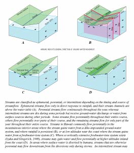
The upper reaches of many Hawaiian streams are within or near the area where volcanic dikes (thin, near-vertical sheets of massive, low-permeability rock that intrude existing rocks) impound ground water to high levels. Streams that intersect the water table of the dike-impounded ground-water body commonly are perennial because they gain water from the ground-water body. However, some streams may lose water to the dike-impounded water body where erosion has not lowered the streams to the water table.
Streams may flow perennially in areas where dikes are not present. For example, in southern Oahu ground water discharges to streams from a thin freshwater-lens system in permeable rocks at altitudes less than a few tens of feet. In eastern Kauai, ground water discharges to streams from a vertically extensive freshwater-lens system (see Izuka and Gingerich, 1998) in low-permeability rocks at altitudes of several hundred feet.
Factors that affect water levels in streams and ground-water bodies can control the interaction between surface water and ground water. These factors include rainfall, ground-water withdrawals, and ocean tides. Rainfall may cause otherwise dry streams to flow, which can lead to discharge from a stream to an underlying ground-water body. Prolonged periods of rainfall may lead to increased ground-water recharge over a region and a rise in ground-water levels. Rising ground-water levels may lead to increased ground-water discharge to streams or reduced surface-water discharge to the ground-water body. Irrigation return flow, like rainfall, may contribute to increased ground-water recharge and affect the interaction between surface water and ground water.
Ground-water withdrawals from wells, shafts, or tunnels cause a decline in ground-water levels that may extend to nearby streams. If the stream and underlying ground-water body are separated by a zone of unsaturated rock, the ground-water withdrawals will not affect streamflow. However, where the stream and ground-water body are hydraulically connected, ground-water withdrawals may reduce ground-water discharge to streams (mainly base flow) or induce flow from the stream to the aquifer.
At low altitudes, water levels in streams and ground-water bodies may be affected by ocean tides. Thus, streams in coastal areas may either gain or lose water during the day depending on the relative effects of the ocean tide on streams and ground-water levels.
Perched ground water is found in areas where low-permeability rocks (weathered rocks, massive lava flows, buried soil and ash layers, or other low-permeability layers) impede the downward movement of water sufficiently to allow a saturated ground-water body to develop in otherwise unsaturated rocks. Perched ground water may interact with surface water, although the discharge of perched water to streams is highly dependent on rainfall.
Streamflow in Hawaii is highly variable both in space and time. Streams that are dry during much of the year are common in the drier, leeward parts of the islands. Streams that flow continuously throughout the year are common in areas that receive significant ground-water discharge. During periods of little or no rainfall, the low-flow characteristics of a stream primarily are dependent on base flow. During periods of heavy rainfall, when stream stage and discharge can increase rapidly, all streams are a potential threat to lives and property.
About 30 percent of the mean annual rainfall statewide is estimated to run off as streamflow. However, the percentage of rainfall that directly runs off varies spatially among basins and temporally within a basin. Among basins, the percentage of mean annual rainfall that runs off typically ranges between 10 and 40 percent, although higher and lower values exist in places. Within a basin, the percentage of rainfall that runs off varies temporally among individual storms, and may range from less than 5 to greater than 50 percent. The percentage of rainfall that runs off is expected to be high where the rainfall amount and intensity are high, permeability of the soils is low, slopes are steep, the water table is at or near the land surface, or antecedent soil moisture is high.
One of the most common statistics used to characterize streamflow is the mean or average value of flow for a particular time scale (for example, daily, monthly, or yearly). Mean streamflow at a site is dependent on the time period over which the mean flow is determined, mainly because of variations in rainfall. For example, the mean annual flow at Kalihi Stream near Honolulu (stream-gaging station 16229000) was 6.41 cubic feet per second for the water years 1914 to 2000, compared to the lowest and highest annual mean flows of 2.04 (1923) and 13.5 (1984) cubic feet per second. Prolonged periods of less than average rainfall may be related to climatic cycles such as El Nino and result in periods of less than long-term average streamflow at a site. Periods of less than average streamflow also can be caused by upstream surface-water diversions or nearby ground-water withdrawals that reduce base flow.
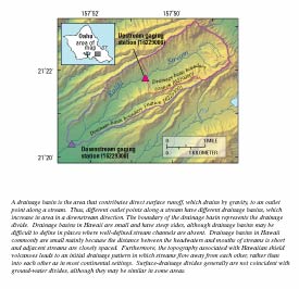
Mean streamflow varies among sites and is dependent on factors including rainfall, drainage basin size, land use, surface-water diversions, and ground-water discharge. Sites in areas with higher rainfall (all other factors being equal) have greater streamflow. Sites draining larger basins commonly have greater streamflow than sites draining smaller basins, as indicated by USGS measurements at two sites on Kalihi Stream during water year 2000. Annual mean flow was 3.7 cubic feet per second at the upstream site (stream-gaging station 16229000, Kalihi Stream near Honolulu), which drains an area of about 2.6 square miles, whereas annual mean flow was 6.8 cubic feet per second at the downstream site (stream-gaging station 16229300, Kalihi Stream near Kalihi), which drains an area of about 5.3 square miles. Streams draining larger areas tend to have greater streamflow because the total volume of rainfall contributing to the area is greater for larger basins.
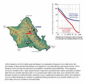
The flow that is equaled or exceeded 90 percent of the time (Q90 flow) is commonly used to characterize low flows in a stream. In Hawaii, Q90 flows may range from near zero for ephemeral streams in areas that receive little rainfall, to tens of cubic feet per second in areas that receive significant rainfall or ground-water discharge. Q90 flows commonly are less than estimated long-term average values of base flow at a site. For perennial streams, estimated long-term average base flow commonly is exceeded less than 90 percent of the time, and in many cases less than 70 percent of the time.
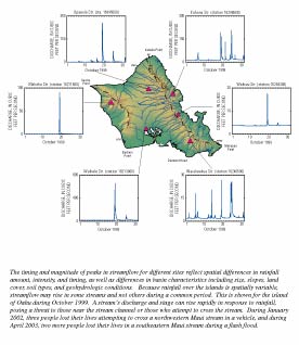
High flows or floods are commonly characterized by their magnitude and recurrence interval on the basis of the largest instantaneous peak discharge for each year of record (annual instantaneous peak flow). The recurrence interval is the expected (average) time between occurrences of annual instantaneous peak flows that exceed a given value. The recurrence interval in years is equal to the inverse of the exceedance probability for annual instantaneous peak flows. Thus, a flood with a 100-year recurrence interval (100-year flood) has an annual exceedance probability of 0.01 (1 percent). Because a 1 percent chance exists for a 100-year flood in any given year, it is possible that more than one 100-year flood may occur during a given 100-year period or even during a single year.
The magnitude of 100-year floods on Oahu at stream-gaging stations ranges from less than 500 to more than 20,000 cubic feet per second. The magnitude of the 100-year flood is commonly hundreds to thousands of times greater than the mean annual flow at a site.
Natural and human-related factors both control surface-water quality in Hawaii. The chemical composition of surface water is dependent on factors including the quality of the source water (rainwater or ground water), geology, soils, vegetation, and land use.
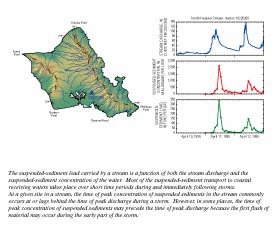
During large storms, suspended-sediment concentrations in streams may increase significantly relative to during low-flow conditions. Because of extensive weathering, fluvial sediments in Hawaii mainly are composed of clay minerals in aggregates of various sizes, generally smaller than sand. These fine brownish-colored particles discolor coastal waters during and following storms.
Volcanic rocks and soils are a source of numerous inorganic constituents (including calcium, magnesium, sodium, potassium and some heavy metals) in stream water. Most of the silica in stream water is derived from volcanic rocks and soil.
In areas where ground water discharges to streams, the quality of the ground water controls surface-water quality during periods of low flow. For example, dike-impounded ground water on Oahu has a silica concentration of about 15 to 25 mg/L, which is similar to the silica concentrations of water from streams in windward Oahu that receive ground-water discharge from the dike-impounded system.
Human activities can affect surface-water quality in a variety of ways: wastewater discharges into streams can lead to increased nutrient concentrations of stream water; construction and agricultural activities can increase the suspended-sediment load in streams; and stream channelization can affect water temperatures. Runoff from agricultural areas may contain constituents including pesticides and nutrients. In addition, urban storm runoff may contain pesticides, nutrients, metals (lead, cadmium, copper, zinc, and others), oil and grease, and polycyclic aromatic hydrocarbons (Oki and Brasher, in press). Paved areas, storm sewers, channelized streams, and surface-water-detention systems also can affect the timing and magnitude of peak discharge and water-quality constituent concentrations during a storm.
The main issues related to surface water in Hawaii include: (1) streamflow availability, (2) the reduction of streamflow by surface diversions and, in some areas, ground-water withdrawals, (3) floods, (4) water-quality changes caused by human activities, and (5) erosion and sediment transport.
Surface-water resources in an area must be quantified before streamflow availability can be evaluated for existing and proposed uses. Quantification is dependent on accurate long-term data. The USGS has operated hundreds of stream-gaging stations in Hawaii, although many are no longer operated and many were operated for only short periods of a few years or less. Long-term streamflow data have not been collected on hundreds of streams (perennial and nonperennial) in Hawaii.
The use of surface water in Hawaii can be a contentious issue. The need for agricultural and municipal water and the streamflow reduction caused by diversions may conflict with traditional Hawaiian practices (taro cultivation and gathering of stream fauna), stream ecology, water quality, recreational activities, and aesthetics. Quantitative instream-flow standards that account for economic, cultural, ecologic, recreational, and aesthetic needs have not yet been established for most streams in Hawaii.
Because land in Hawaii is limited, flood-prone areas continue to be used for residential and agricultural purposes, resulting in loss of property and lives during floods. Characterizing the magnitude and frequency of floods in an area is vital for the safe and efficient design of roads, bridges, water-conveyance structures, and flood-control projects, and management of flood plains and flood-prone areas.
The quality of Hawaii's surface waters has been affected by urban and agricultural activities. Fish from streams in urban Honolulu have been found to have some of the highest levels of organochlorine pesticides in the Nation (Brasher and Anthony, 2000). Concrete-lined stream channels may lead to loss of habitat and increased water temperatures that may affect native aquatic species.
In areas disturbed by construction or landslides, erosion may produce thousands of tons of sediment per square mile annually. Erosion and sediment transport can (1) increase turbidity, reduce instream water quality, and impair aquatic habitat; (2) transport adsorbed contaminants to coastal receiving waters; (3) impair aesthetics of recreational coastal waters; and (4) smother coral reefs with sediment.
Leptospirosis is a disease that may be transmitted to humans who come into contact with the urine of infected animals; it is commonly associated with swimming or wading in HawaiiÂ’s streams and is a significant public-health concern.
Brasher, A.M., and Anthony, S.S., 2000, Occurrence of organochlorine pesticides in stream bed sediment and fish from selected streams on the island of Oahu, Hawaii, 1998: U.S. Geological Survey Fact Sheet 140-00, 6 p.
Fontaine, R.A., 1996, Evaluation of the surface-water quantity, surface-water quality, and rainfall data-collection programs in Hawaii, 1994: U.S. Geological Survey Water-Resources Investigations Report 95-4212, 125 p.
Fontaine, R.A., and Hill, B.R., 2002, Streamflow and erosion response to prolonged intense rainfall of November 1-2, 2000, island of Hawaii, Hawaii: U.S. Geological Survey Water-Resources Investigations Report 02-4117, 31 p.
Giambelluca, T.W., Nullet, M.A., and Schroeder, T.A., 1986, Rainfall atlas of Hawaii: State of Hawaii, Department of Land and Natural Resources, Report R76, 267 p.
Gingerich, S.B., and Oki, D.S., 2000, Ground water in Hawaii: U.S. Geological Survey Fact Sheet 126-00, 6 p.
Hawaii Cooperative Park Service Unit, 1990, Hawaii stream assessment: A preliminary appraisal of Hawaii's stream resources: State of Hawaii, Department of Land and Natural Resources, Commission on Water Resource Management, Report R84, 294 p.
Izuka, S.K., and Gingerich, S.B., 1998, Ground water in the southern Lihue Basin, Kauai, Hawaii: U.S. Geological Survey Water-Resources Investigations Report 98-4031, 71 p.
Macdonald, G.A., Abbott, A.T., and Peterson, F.L., 1983, Volcanoes in the sea: The geology of Hawaii (2d ed.): Honolulu, Hawaii, University of Hawaii Press, 517 p.
Oki, D.S., and Brasher, A.M.D., in press, Environmental setting and the effects of natural and human-related factors on water quality and aquatic biota, Oahu, Hawaii: U.S. Geological Survey Water-Resources Investigations Report 03-4156.
Takasaki, K.J., 1978, Summary appraisals of the Nation's ground-water resources - Hawaii region: U.S. Geological Survey Professional Paper 813-M, 29 p.
Takasaki, K.J., and Mink, J.F., 1985, Evaluation of major dike-impounded ground-water reservoirs, island of Oahu: U.S. Geological Survey Water-Supply Paper 2217, 77 p.
Taogoshi, R.I., Nishimoto, D.C., Fontaine, R.A., Wong, M.F., and Hill, B.R., 2001, Water resources data Hawaii and other Pacific areas water year 2000, volume 1. Hawaii: U.S. Geological Survey Water-Data Report HI-00-1, 379 p.
Wahl, K.L., and Wahl, T.L., 1995, Determining the flow of Comal Springs at New Braunfels, Texas: Proceedings of Texas Water - 95, A Component Conference of the First International Conference on Water Resources Engineering, American Society of Civil Engineers, August 16-17, 1995, San Antonio, Texas, p. 77-86.
Wong, M.F., 1994, Estimation of magnitude and frequency of floods for streams on the island of Oahu, Hawaii: U.S. Geological Survey Water-Resources Investigations Report 94-4052, 37 p.
View a PDF version (not accessible) [2,870 Kb] of this fact sheetCitation: Oki, D.S., 2003, Surface Water in Hawaii: U.S. Geological Survey Fact Sheet 045-03, 6 p.