 |
|
| Ground water withdrawn for water supply reduces streamflow in the Hunt-Annaquatucket-Pettaquamscutt Basin in Rhode Island. These reductions may adversely affect aquatic habitats. A hydrologic model was prepared by the U.S. Geological Survey in cooperation with the Rhode Island Water Resources Board, Town of North Kingstown, Rhode Island Department of Environmental Management, and Rhode Island Economic Development Corporation to aid water-resource planning in the basin. Results of the model provide information that helps water suppliers and natural-resource managers evaluate strategies for balancing ground-water development and streamflow reductions in the basin. |
The Hunt-Annaquatucket-Pettaquamscutt (HAP) aquifer (fig.1) supplies water to North Kingstown and parts of Warwick, East Greenwich, and Narragansett, Rhode Island. Ground-water withdrawals from the aquifer have exceeded 8 million gallons per day (Mgal/d) during months of peak water use, and growing water-supply demands may require additional withdrawals. Although the aquifer provides substantial amounts of high-quality water, ground-water withdrawals reduce streamflow in the HAP Basin. These reductions occur because streams and ponds in the basin are hydraulically connected to the aquifer and receive most of their water from ground-water discharge (fig.2). During periods of lower streamflow in the summer, these reductions may adversely affect aquatic and riparian habitats of the streams.
Concerns by natural-resource managers regarding how ground-water withdrawals affect streamflow in the HAP Basin prompted the development of a basin-wide hydrologic model to provide information to assist water suppliers and natural-resource managers evaluate trade-offs between ground-water development and streamflow reductions. This Fact Sheet describes the development and selected applications of the model.
 |
|
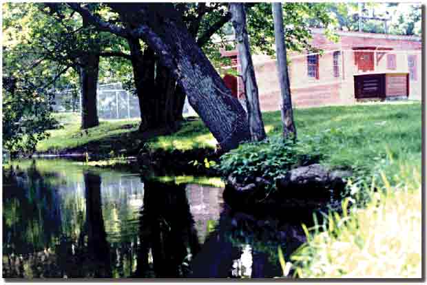
Water-supply well house near the Hunt River, East Greenwich, Rhode Island |
The HAP Basin covers 39.6 square miles, about half of which is underlain by the HAP aquifer. The aquifer consists of highly permeable stratified sand-and-gravel sediments deposited by glacial meltwater thousands of years ago. The remainder of the basin consists of upland areas underlain by glacial till, bedrock, and small, isolated areas of stratified sand and gravel.
The uppermost boundary of the HAP aquifer is the water table, which ranges in depth from less than one foot below land surface near rivers, ponds, and wetlands, to as much as 70 feet below land surface near upland areas. Precipitation (rain and snow), seepage from streams, ground water that flows to the aquifer from uplands areas, and a small amount of wastewater discharge in unsewered areas recharge the aquifer. Total recharge to the aquifer averaged about 43 Mgal/d from 1941 to 1996, with precipitation being the largest single source (22 Mgal/d).
Most of the water that recharges the aquifer eventually discharges to the rivers, brooks, and ponds in the basin. On average, 34 Mgal/d of ground water discharges to these surface waters. A relatively small amount of the recharge evaporates directly from the water table or transpires from plants where the water table is close to land surface (fig.2). Ground water is withdrawn from the aquifer by 18 water-supply wells (fig.1), 14 of which are public-supply wells operated by the Town of North Kingstown, Rhode Island Economic Development Corporation, and Kent County Water Authority. Total withdrawals from these 18 wells averaged 5 Mgal/d from 1941 to 1996. Streamflow leaves the basin in the Hunt, Annaquatucket, and Pettaquamscutt Rivers, and Cocumcossuc and Queens Fort Brooks (fig.1). Total streamflow out of the basin was estimated at about 50 Mgal/d (77 cubic feet per second, ft3/s); streamflow in the Hunt River was the largest component (30 Mgal/d, or 46 ft3/s).
The hydrologic model developed for the HAP Basin consists of two componentsa simulation model and a management model. The simulation model mathematically represents the hydrologic system. The model simulates ground-water flow in the HAP aquifer and accounts for the most important features of the hydrologic system, such as ground-water recharge, withdrawals, and interactions between ground water and surface waters. The simulation model was developed on the basis of hydrologic and geologic data collected as part of the investigation. Output from the model includes calculated ground-water levels for the aquifer and flow rates in the Hunt, Annaquatucket, and Pettaquamscutt Rivers.
The management model addresses ground-water withdrawal and streamflow-reduction issues; it is used to examine physical factors that affect trade-offs between ground-water withdrawals and streamflow in the basin. The management model consists of a water-resource planning objective and a set of planning constraints. The objective is to maximize total ground-water withdrawal from the HAP aquifer from July through September. The amount of ground water that could be withdrawn, however, is limited by three constraints: (1) minimum streamflow requirements in the Hunt, Annaquatucket, and Pettaquamscutt Rivers, (2) water-supply demands equal to or greater than the average demands in the basin during 199398, and (3) maximum withdrawal rates at each of the public-supply wells. The model calculates an annual schedule of monthly withdrawal rates at each public-supply well; this schedule meets the planning objective and all of the constraints.
To illustrate how the model can aid water-resource planning in the basin, three issues were considered:
- Can ground-water withdrawals be increased without further reducing streamflow during the summer?
- Can streamflow in the Hunt River be increased during the summer?
- How are water-resource plans affected by streamflows in the Annaquatucket and Pettaquamscutt Rivers?
Results of the model were compared to average ground-water withdrawals and estimated average streamflows during 199398, which are referred to as the current conditions.
Increased Summer Ground-Water Withdrawals
Ground-water withdrawals reduce streamflow throughout the year, but the reductions are largest during the summer. Estimated current rates of streamflow reduction at the end of July, August, and September range from 2.8 to 3.1 Mgal/d for the Hunt River, 1.3 to 1.9 Mgal/d for the Annaquatucket River, and 0.2 to 0.4 Mgal/d for the Pettaquamscutt River (table 1).
The model was first used to determine if summer ground-water withdrawals could be increased without further reducing summer streamflow in the Hunt, Annaquatucket, or Pettaquamscutt Rivers. Model results indicated that total ground-water withdrawal from the current net-work of 14 public-supply wells could be increased by an average of 0.4 Mgal/d over the current withdrawal rate of 5.5 Mgal/d. A larger increase of 1.0 Mgal/d would be possible if the network of supply wells is modified to include two new wells in the Annaquatucket River Basin (wells H1 and H2, fig. 1) that have been identified as possible new well sites. For either network of supply wells, the source of the additional withdrawal is ground water that otherwise would have discharged to the rivers during OctoberJune, when streamflows are generally higher than during the summer.
Increased Summer Streamflow in the Hunt River
Ground-water withdrawals in the Hunt River Basin are larger than those in either the Annaquatucket or Pettaquamscutt River Basins (table 1). Consequently, the Hunt River has experienced the largest rates of streamflow reduction. The hydrologic model was used to determine if streamflow in the Hunt River could be increased during the summer without further reducing summer streamflows in the Annaquatucket or Pettaquamscutt Rivers and while withdrawing sufficient water to meet current demands.
Results of model simulations indicated that summer streamflow in the Hunt River could be increased an average of about 0.2 Mgal/d (0.3 ft3/s) if current ground-water withdrawal schedules at the 14 public-supply wells are changed. Alternatively, a larger increase of about 0.4 Mgal/d (0.6 ft3/s) could be obtained with the modified network of supply wells.
Water-Resource Plans and Streamflows in the Annaquatucket and Pettaquamscutt Rivers
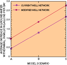
Total ground-water withdrawals from the HAP aquifer can be increased if streamflows in the Annaquatucket and Pettaquamscutt Rivers are allowed to be reduced below the estimated 199398 average rates, as demonstrated by three scenarios simulated by the hydrologic model. In scenario A, specified summer streamflows in the Annaquatucket and Pettaquamscutt Rivers were maintained at the current average rates (table 2). In scenario C, specified summer streamflows in the two rivers were set equal to 75 percent of the estimated pre-development streamflow in each river. A value of 75 percent was chosen for consistency with the estimated current summer streamflow in the Hunt River, the most stressed of the three rivers. In scenario B, summer streamflows in the two rivers were specified midway between scenarios A and C.
Results of the hydrologic model for these three scenarios indicated that summer ground-water withdrawals can be increased from 0.4 to 2.2 Mgal/d by use of the current network of supply wells, and can be increased from 1.0 to 2.8 Mgal/d for the modified network of supply wells (fig. 3). These increases, which are as much as 50 percent greater than the average 199398 withdrawal rate of 5.5 Mgal/d, are possible without further reductions in summer streamflow in the Hunt River.
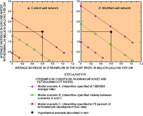
The results of additional model scenarios indicate that summer streamflow in the Hunt River can be increased as much as 1.0 Mgal/d (1.5 ft3/s) if stream-flows in the Annaquatucket and Pettaquamscutt Rivers decline to rates specified in scenarios B and C (fig. 4).
Model results shown on figure 4 summarize the trade-offs among (1) increasing ground-water withdrawals from the HAP aquifer, (2) increasing streamflow in the Hunt River, and (3) reducing streamflow in the Annaquatucket and Pettaquamscutt Rivers. The graphs indicate that ground-water withdrawals from the aquifer and streamflow in the Hunt River can be increased if streamflows in the Annaquatucket and Pettaquamscutt Rivers decrease. The graphs also indicate that increasing streamflow in the Hunt River reduces possible future increases in ground-water withdrawals from the aquifer.
|
|
|
||
|
Figure 3. Average increase in ground-water withdrawals from the Hunt-Annaquatucket-Pettaquamscutt aquifer, Rhode Island, during July, August, and September, calculated for three scenarios of the hydrologic model. |
Figure 4. Average increase in ground-water withdrawals from the Hunt-Annaquatucket-Pettaquamscutt aquifer, Rhode Island during July, August, and September, as a function of increased streamflow in the Hunt River, calculated by the hydrologic model for three scenarios of streamflows in the Annaquatucket and Pettaquamscutt Rivers. (To convert to cubic feet per second, multiply million gallons per day by 1.547) |
The graphs in figure 4 provide a tool for initial analysis of proposed water-resource plans. A hypothetical example illustrates how the graphs can be used in this way. Water suppliers want to increase ground-water withdrawals an additional 1.5 Mgal/d to meet increased summer demands. Simultaneously, natural-resource managers want to increase the average rate of summer streamflow in the Hunt River by 0.6 Mgal/d (0.9 ft3/s) to improve the aquatic and riparian habitats of the river. Can these two objectives be met? Model results on figure 4A show that the objectives cannot be met with the current network of supply wells and with summer streamflows in the Annaquatucket and Pettaquamscutt Rivers equal to or greater than 75 percent of pre-development flow rates. Model results on figure 4B, however, show that the objectives could be met by the modified network of supply wells, but would require that summer streamflows in the Annaquatucket and Pettaquamscutt Rivers be reduced to nearly 75 percent of pre-development flow rates. The specific withdrawal schedules at the public-supply wells required to meet these objectives could then be determined by use of the hydrologic model.
The hydrologic model could be used to assess the feasibility of similar proposed water-resource plans. Additionally, many aspects of the hydrologic model could be modified in future applications, including the number and location of supply wells, specified streamflow requirements, water-supply demands, and simulated hydrologic conditions.
This Fact Sheet is based on information published in two reports by the U.S. Geological Survey:
Barlow, P.M., and Dickerman, D.C., 2001, Numerical-simulation and conjunctive-management models of the Hunt-Annaquatucket-Pettaquamscutt stream-aquifer system, Rhode Island: U.S. Geological Survey Professional Paper 1636, 88 p.
Dickerman, D.C., and Barlow, P.M., 1997, Water-table conditions and stream-aquifer interaction in the Hunt-Annaquatucket-Pettaquamscutt aquifer, central Rhode Island, October 79, 1996: U.S. Geological Survey Water-Resources Investigations Report 97-4167, 1 sheet.
By Paul M. Barlow and David C. Dickerman
Photography by Emily C. Wild
For additional information contact:
Deputy Director, Rhode Island Office
U.S. Geological Survey
275 Promenade Street, Suite 150
Providence, RI 02908
(401) 331-9050
World Wide Web: http://ri.water.usgs.gov/ or http://water.usgs.gov/
| AccessibilityFOIAPrivacyPolicies and Notices | |
 |
|