Link to USGS home page
Coastal and Marine Geology Program
Coastal & Marine Geology Program >Subsidence and Fault Activation . . . >Fact Sheet FS-091-01

Return to: Faults & Releveling Surveys

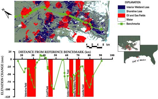
Figure 5. Map along Louisiana Highway 1 between Valentine and Leeville, La., showing locations of benchmarks, oil and gas fields, and shoreline and wetland losses and graph showing changes in surface elevation (in millimeters) at the benchmarks between 1965 and 1982. Subsidence was greatest near the oil and gas fields. Wetland losses from Britsch and Dunbar (1993). Elevation changes from National Geodetic Survey data.
Map along Louisiana Highway 1 between Valentine and Leeville, La., showing locations of benchmarks, oil and gas fields, and shoreline and wetland losses and graph showing changes in surface elevation (in millimeters) at the benchmarks between 1965 and 1982.

Return to: Faults & Releveling Surveys

Coastal & Marine Geology Program >Subsidence and Fault Activation . . . >Fact Sheet FS-091-01

[an error occurred while processing this directive]