|  | IntroductionWetland losses are so extensive in the Gulf of Mexico Coast region of the United States that they represent critical concerns to government environmental agencies and natural resource managers. Each year, millions of dollars are spent in coastal Louisiana alone to restore wetlands and to maintain the natural ecosystem that is vital to the Nation's economy. 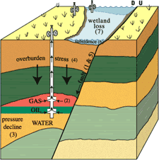 | Figure 1. Possible effects of petroleum production. Prolonged or rapid production of oil, gas, and formation water (2) causes subsurface formation pressures to decline (3). The lowered pressures (3) increase the effective stress of the overburden (4), which causes compaction of the reservoir rocks and may cause formerly active faults (1) to be reactivated (5). Either compaction of the strata or downward displacement along faults can cause land-surface subsidence (6). Where subsidence and fault reactivation occur in wetland areas, the wetlands typically are submerged and changed to open water (7). Figure is not to scale. D, down; U, up. [larger version] | Wetland subsidence and fault reactivation induced by oil and gas production generally have been disregarded in the Gulf Coast region because much of the wetland loss occurs in Louisiana, where many other factors contribute to coastal change (Williams and others, 1994). Understanding the influence of hydrocarbon production on wetland changes is important for predicting future wetland conditions and for planning wetland restoration projects. Hydrocarbon production is interpreted to cause movement along faults and wetland subsidence (fig. 1) if the following situations co-occur: - Large areas of wetland are lost at the same time and in the same places as hydrocarbons are produced
- The cumulative volumes of fluids produced are so large that they lead to rapid declines in subsurface pressures
- Subsurface faults near the producing reservoirs and surface faults activated after initial production have the same orientation and direction of displacement
- Subsidence rates measured near the oil and gas wells during production are substantially higher than geological rates of subsidence
Each condition by itself does not directly link wetland loss, subsidence, and hydrocarbon production, but together they are compelling indicators of causality.Subsidence & Hydrocarbon Production » | |
Related Publication: Shallow Stratigraphic Evidence of Subsidence and Faulting Induced by Hydrocarbon Production in Coastal Southeast Texas - USGS Open File Report 01-274
USGS Coastal & Marine Geology Program
|