Coastal & Marine Geology Program
>
Subsidence and Fault Activation . . .
>
Fact Sheet FS-091-01
Return to:
Correlations
& Rates
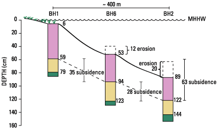
Figure 6.
Stratigraphic correlations of shallow sediment cores illustrate the magnitude of wetland subsidence and erosion (in centimeters) at the Port Neches Field, Tex. The top unit consists of marsh sediments. MHHW, mean higher high water.
Return to:
Correlations& Rates
Coastal & Marine Geology Program
>
Subsidence and Fault Activation . . .
>
Fact Sheet FS-091-01
[an error occurred while processing this directive]