
U.S. Geological Survey Fact Sheet 115-99
COAL RESOURCE ASSESSMENTS IN THE
NORTHERN AND CENTRAL APPALACHIAN COAL REGION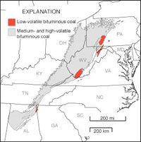
Coal has been mined actively and extensively in the Appalachian coal region since the mid-1800's. In some areas, production from major coal beds began to decline as early as 1907. Nevertheless, 40 percent of U.S. coal production still comes from the States of Ohio, Pennsylvania, West Virginia, Virginia, Maryland, eastern Kentucky, and Tennessee. Even though many of these coal beds are still being mined at top production levels, information on the distribution and quality of remaining coal in the northern and central Appalachians is obsolete; in some areas, the last detailed maps of the coal beds were made nearly 90 years ago. To respond to present needs, including clean air standards and growing concern about potential hazardous pollutants in coal, we need up-to-date information on the amount of remaining coal, its quality, and its distribution. The text and graphics of Coal Resource Assessments in the Northern and Central Appalachian Coal Region are presented here in two versions:
If you have Adobe Acrobat Reader installed on your computer, you may view and/or print the PDF version of this report. If you do not have Acrobat Reader, you may download it here:

Return to 1999 Fact Sheets This site is https://pubs.usgs.gov/factsheet/fs115-99/
Maintained by the Eastern Publications Group Web Team
Last revised 11-30-99 (krw)