Link to USGS home page Link to USGS home page
Coastal and Marine Geology Program
Coastal and Marine Geology Program > Natural Disasters—Forecasting Economic and Life Losses

Natural Disasters—Forecasting Economic and Life Losses

USGS Fact Sheet

Dr. Christopher Barton Dr. Stuart Nishenko
Dr. Christopher Barton (left) and Dr. Stuart Nishenko.
"Events such as hurricanes, earthquakes, floods, tsunamis, volcanic eruptions, and tornadoes are natural disasters because they negatively impact society, and so they must be measured and understood in human-related terms. At the U.S. Geological Survey, we have developed a new method to examine fatality and dollar-loss data, and to make probabilistic estimates of the frequency and magnitude of future events. This information is vital to large sectors of society including disaster relief agencies and insurance companies."

- Dr. Christopher Barton and Dr. Stuart Nishenko, U.S. Geological Survey

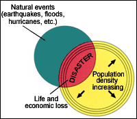
Natural disasters have become so expensive that the Federal Government shares in the economic risk. Forecasting this risk is therefore a significant issue.

Insurance coverage for losses resulting from natural disasters is typically less than 20 percent of the total loss, because of limited participation in voluntary insurance coverage. The remainder of the dollar losses are covered by the Federal Government through emergency allocations, the amount of which can increase the national debt. As a result of Hurricane Andrew, where the losses may exceed 25 billion dollars, the U.S. Congress is examining the feasibility of establishing a National "insurance" fund from which uninsured losses can be paid when natural disasters strike. Forecasts of future losses based on traditional interpretations of available data produce highly variable results and seemingly yield few patterns. A new method developed by USGS scientists addresses the issue of forecasting the size and number of national disasters and their attendant losses.

Natural disasters represent the intersection of two sets: nature and population. As the population continues to grow, so does the area of intersection, leading to costlier and deadlier disasters. Natural disasters are a "growth" industry. Since the 1960s, economic losses from natural disasters on a global scale have tripled, while insured losses have quintupled.
Natural disasters represent the intersection of two sets—nature and population. As the population continues to grow, so does the area of intersection, leading to costlier and deadlier disasters. Natural disasters are a "growth" industry. Since the 1960s, economic losses from natural disasters on a global scale have tripled, while insured losses have quintupled. (after Berz, 1992, Natural Hazards, 5, 95-102) [larger version]

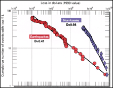
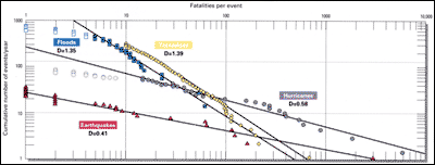
The U.S. Geological Survey (USGS) is a participant in the International Decade of Natural Disaster Reduction.

The 1990s are designated as the International Decade of Natural Disaster Reduction, and the U.S. is a signatory to the United Nations' treaty. Studies by USGS researchers contribute to this treaty by defining a quantitative basis for developing models for the loss of life and property resulting from natural disasters. This research is conducted cooperatively with Prof. Sarah Tebbens of the University of South Florida, and Prof. Donald Turcotte of Cornell University. Data from the USGS, the National Oceanic and Atmospheric Administration (NOAA), the Agency for International Development, and other agencies are used to develop an understanding of how a particular natural disaster scales, or relates, to other disasters caused by the same phenomenon, and to disasters caused by other phenomena. These relationships are fundamental to the development and evaluation of national disaster planning, mitigation, and hazard reduction efforts.

In this study, USGS scientists examine the magnitude of disasters as measured by dollars and fatalities, as well as by traditional scientific parameters.

Natural high-energy events, such as hurricanes and earthquakes, are complex phenomena whose cumulative size-frequency distributions exhibit fractal scaling properties; that is, plots of logarithms of the size and cumulative frequency data follow a straight line. The slope of this line is the scaling exponent or fractal dimension (D). Preliminary results of this research, funded by the USGS G.K. Gilbert Fellowship Program, suggest that the loss of life and property due to natural disasters exhibit self-similar scaling behavior. It is this self-similar scaling property that allows use of frequent small events to estimate the rate of occurrence of less frequent, larger events. Examining the fractal behavior of loss data for disasters of all scales has important advantages because one can forecast the probability of occurrence of a disaster over a wide range of years (1 year to 1,000 years); compare one type of disaster with another; compare disasters in one region with similar disasters in another region; and, measure the effectiveness of planning and mitigation strategies.

Plot of cumulative frequency of dollar loss due to earthquakes and hurricanes in the U.S. between 1900 and 1989. Plot of cumulative frequency of dollar loss due to earthquakes and hurricanes in the U.S. between 1900 and 1989. Data presented in this manner reveal linear trends which provide the basis for forecasting the probability of future dollar loss. [larger version]

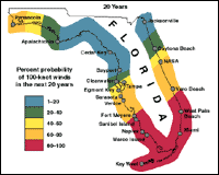
The fractal behavior of hurricanes provides a basis for estimating their size and number.

Of all the natural disasters in the United States, hurricanes account for about two-thirds of the insured property losses. Results of analyses give characteristic fractal-scaling values that reveal two populations of storms: those with sustained wind speeds below about 85 knots, or tropical storms; and those with sustained wind speeds above 85 knots, or hurricanes. The fractal-scaling law can be used to make a probabilistic forecast of the frequency of hurricanes of any given size for a city or a region. A typical example is that for the region around Tampa Bay, Florida.

(A) Property losses from hurricanes in the continental U.S. by decade. (B) Loss of life due to hurricanes in the continental U.S. by decade.
(A) Property losses from hurricanes in the continental U.S. by decade. (B) Loss of life due to hurricanes in the continental U.S. by decade. (Data from NOAA). Property losses due to hurricanes have grown rapidly in this century and are expected to grow more rapidly in the future. Hurricane tracking and early-warning systems developed by NOAA have dramatically reduced the loss of life due to hurricanes, but have had little effect on property loss. [larger version]
Map showing tracks of the deadliest and costliest hurricanes that occurred in the U.S. between 1900 and 1993.
Map showing tracks of the deadliest and costliest hurricanes that occurred in the U.S. between 1900 and 1993. (Data from NOAA). [larger version]

106 years of storm data for Tampa Bay region, Florida provides the basis for establishing scaling laws for wind speed and time intervals between storms.
106 years of storm data for Tampa Bay region, Florida provides the basis for establishing scaling laws for wind speed and time intervals between storms. The insight provided by a log-log plot of data is shown (above) for maximum wind speed (on left) and for time intervals between storms (on right). Traditionally, data are plotted on a histogram plot (A and D). Structure in the data becomes apparent when data are replotted on logarithmic scales where two populations become clear (B) and scaling is revealed (E). Axes on the plot are converted to probability in (C and F) which permits extrapolation to forecast the probability of greater wind speeds and time intervals between storms. (Data from NOAA). [larger version]

The frequency of Florida hurricanes with wind speeds greater than or equal to 100 knots is mapped in terms of the probability of occurrence during a 20 year exposure window. The frequency of Florida hurricanes with wind speeds greater than or equal to 100 knots is mapped in terms of the probability of occurrence during a 20 year exposure window. These probabilistic estimates, based on 106 years of observations, illustrate that hurricanes with 100 knot winds occur more frequently in southern Florida, and gradually decrease in frequency towards northern Florida. [larger version]

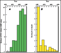
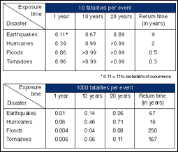
USGS studies indicate that life and property losses from earthquakes, hurricanes, floods, and tornadoes exhibit fractal scaling behavior which can be used to forecast future losses.

Earthquakes are examples of complex natural high-energy phenomena whose cumulative size-frequency distributions have long been known to exhibit fractal (power-law) scaling properties. USGS researchers have recently discovered that fractal scaling laws also apply to distributions of the loss of life and property brought on by natural disasters. Fatality data from countries with large earthquake losses during the 20th century demonstrate power-law scaling over 3 to 4 orders of magnitude in loss. These relationships provide a quantitative basis to compare losses from different geographic regions, and different time periods. The self-similar scaling properties of power-law distributions allow forecasting of larger events from the behavior of smaller events, as well as comparison of losses from other types of natural disasters. Not all disasters have the same impact. USGS researchers conclude that on an annual basis in the United States, the majority of small fatality events (10 per event) are related to floods and tornadoes; larger fatality events (1000 per event), are less frequent and are dominated by hurricanes and earthquakes. Disaster mitigation strategies need to account for these differences.

Comparison of natural disaster fatalities in the United States. Cumulative size-frequency distributions for annual earthquake, flood, hurricane, and tornado fatalities.
Comparison of natural disaster fatalities in the United States. Cumulative size-frequency distributions for annual earthquake, flood, hurricane, and tornado fatalities. In addition to demonstrating linear behavior over 2 to 3 orders of magnitude in loss, these data group into two families. Earthquakes and tornadoes are associated with relatively flat slopes (D=0.4 - 0.6); while floods and tornadoes have steeper slopes (D=1.3 - 1.4). Open symbols were not used to calculate slope of lines. [larger version]

Probability estimates for the occurrence of earthquake, hurricane, flood, and tornado disasters with 10 and 1000 fatalities per event in the United States during 1, 10, and 20 year exposure times, and estimates of the mean return time in years. Probability estimates for the occurrence of earthquake, hurricane, flood, and tornado disasters with 10 and 1000 fatalities per event in the United States during 1, 10, and 20 year exposure times, and estimates of the mean return time in years. Note the reversal in recurrence times for small and large events. Floods and tornadoes have relatively shorter return times for small events, while earthquakes and hurricanes have relatively short return times for large events. [larger version]

Contact Information
Dr. Christopher Barton
U.S. Geological Survey
600 Fourth Street South
St. Petersburg, FL 33701
Phone: (727) 803-8747
Fax: (727) 803-2032
Email: barton@usgs.gov


Related Research Projects:

Hurricane and Extreme Storm Impact Studies
USGS Coastal & Marine Geology Program

Earthquake Hazards Program
USGS Coastal

Central California/San Francisco Bay Earthquake Hazards Project
USGS Coastal & Marine Geology Program

Related Publications:

Earthquakes - USGS General Interest Publication
USGS

Large Floods in the United States: Where They Happen and Why - USGS Circular 1245
USGS

Related Links:

National Earthquake Information Center
USGS

Cornell University
Cornell University

University of South Florida

National Oceanic and Atmospheric Administration
U.S. Department of Commerce


Coastal and Marine Geology Program > Natural Disasters—Forecasting Economic and Life Losses


Accessibility FOIA Privacy Policies and Notices

Take Pride in America logo USA.gov logo U.S. Department of the Interior | U.S. Geological Survey
URL: http://pubsdata.usgs.gov/pubs/fs/natural-disasters/index.html
Page Contact Information: GS Pubs Web Contact
Page Last Modified: Tuesday, 29-Nov-2016 17:58:04 EST