
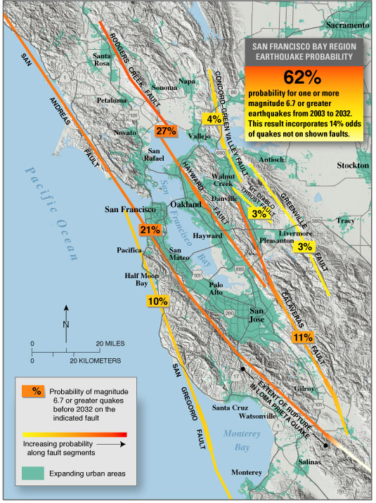
| Using newly collected data and evolving theories of earthquake occurrence, U.S. Geological Survey (USGS) and other scientists now conclude that there is a 62% probability of at least one magnitude 6.7 or greater quake, capable of causing widespread damage, striking somewhere in the San Francisco Bay region before 2032. A major quake can occur in any part of this densely populated region. Therefore, there is an ongoing need for all communities in the Bay region to continue preparing for the quakes that will strike in the future. |
 |
| The threat of earthquakes extends across the entire San Francisco Bay region, and a major quake is likely before 2032. Knowing this will help people make informed decisions as they continue to prepare for future quakes. |
Since the great earthquake of 1906, no major quake has been centered near a
densely urbanized part of the San Francisco Bay region. Although the 1989 magnitude
6.9 Loma Prieta quake killed more than 40 people in the region’s urban
core, it was centered in mountainous country 50 miles south of San Francisco.
In 1995, when a quake of the same magnitude struck Kobe, Japan, another bayside
urban area thought to be well prepared for earthquakes, more than 6,000 people
died and the damage amounted to $100 billion. Had the Loma Prieta quake been
centered in San Jose, Oakland, or San Francisco, similar losses could have occurred.
Damaging earthquakes are inevitable in the Bay region, but taking actions based
on the likelihood of future quakes will help save lives and protect property.
Following the Loma Prieta quake, the U.S. Geological Survey’s (USGS) Working
Group on California Earthquake Probabilities reassessed the likelihood of large
quakes striking the Bay region and issued a report in 1990.
Since then, scientists have gained new insights into Bay region earthquakes,
providing a better basis for determining future quake probabilities. The USGS
working group was expanded to include about 100 scientists from Federal and
State of California agencies, consulting firms, industry, and universities.
In 1999, results from this expanded working group were published in USGS Fact
Sheet 152-99 and USGS Open-File Report 99-517. The efforts of this continuing
working group, now called WG02, have produced a new assessment of Bay region
earthquake probabilities that is published in this Fact Sheet and more fully
in USGS Open-File Report 03-214. WG02 determined that there is a 62% chance of at least
one magnitude 6.7 or greater earthquake striking the San Francisco Bay region
between 2003 and 2032.
The population of this region is projected to exceed 8.2 million people by
2025—an increase of more than 1.4 million from the 2000 census level. Nearly
all of this growth is expected to occur in the northern and eastern parts of
the region. Solano, Napa, and Sonoma Counties are anticipated to show the highest
growth, adding more than 30% to their populations. Contra Costa, Alameda, and
Santa Clara Counties are projected to see a 15 to 20% increase in population.
This eastward and northward growth of the region will occur in areas of significant
seismic hazard, a fact not fully appreciated until recently. The cumulative
30-year probability of an earthquake of magnitude 6.7 or greater occurring somewhere
within these rapidly growing northern and eastern areas alone is nearly 50%.
Residents living near the Pacific coast in San Mateo, Santa Cruz, and Monterey
Counties are sandwiched between the San Andreas and San Gregorio Faults. These
two faults have a combined 34% chance of producing one or more magnitude 6.7
or greater quakes in these coastal areas before 2032.
When the 1990 USGS probability report was released, earthquake likelihood could
be estimated only for the San Andreas Fault and the Hayward-Rodgers Creek Fault,
although the danger posed by other faults was recognized. WG02 found that, of
all the faults in the Bay region, these two and the Calaveras Fault still pose
the greatest threat, because they have high quake odds and run through the region’s
urban core.
Since 1990, new data have allowed five additional faults to be included in
the probability calculations. Furthermore, there is now a focus on events of
magnitude 6.7 and greater rather than 7 and greater, because the 1994 Northridge
quake in southern California was only magnitude 6.7 yet killed 57 people and
caused more than $20 billion in damage. Including more faults and smaller events
would be expected to increase the estimated regional probability of major quakes.
This expected increase was more than compensated for, however, by two effects
not included in the 1990 report: (1) gradual slip on faults in the absence of
earthquakes and (2) the effect of the 1906 earthquake in reducing quake activity
throughout the region.
The rate of large earthquakes in the Bay region dropped abruptly after the
1906 earthquake and has only slightly increased during the last few decades.
How long it will take to again reach the level of activity seen in the late
1800’s is a question that WG02 carefully evaluated. The new average regional
quake probability of 62% is a result of considering several earthquake theories,
which produce probabilities from 37 to 87%. As earthquake science progresses,
this and other uncertainties should diminish and the average probability may
change.
Any magnitude 6.7 or greater quake can cause damage throughout the Bay region, but even a smaller quake could have serious effects if centered in an urbanized area. WG02 found at least an 80% chance of one or more magnitude 6 to 6.6 quakes occurring in the Bay region before 2032.
 |
|
 |
|
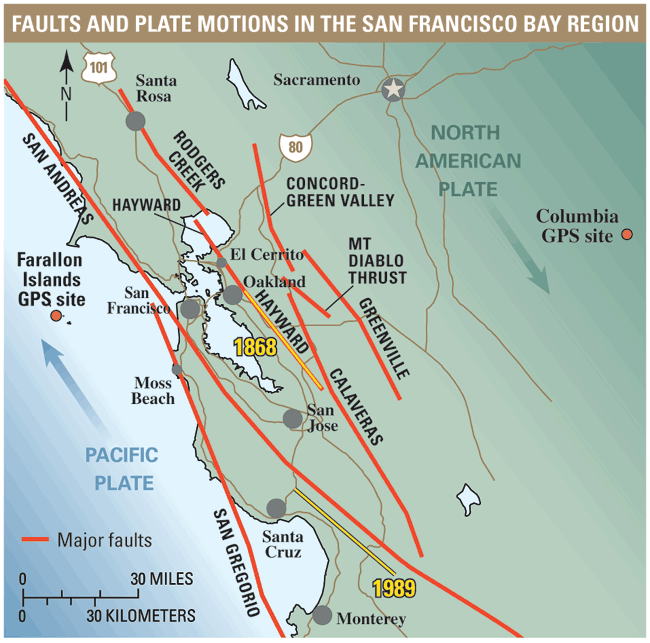
| The San Francisco Bay region lies on the boundary zone between two of the tectonic plates that make up the Earth’s outer shell. The relentless motion of these plates builds up strain that will eventually be released in earthquakes on the region’s many faults. Map above shows the northwestward movement of the Farallon Islands relative to Columbia in eastern California, as documented by Global Positioning System (GPS) data from those two sites. The lengths of fault that slipped in the 1868 Hayward and 1989 Loma Prieta magnitude 6.9 earthquakes areshown in yellow. |  |
| next page |
| Help | Geopubs main page | Fact Sheets |
| Department of the Interior
| Privacy Statement | Disclaimer
| Accessibility |
URL of this page: https://pubs.usgs.gov/fs/2003/fs039-03/
Maintained by: Michael Diggles
Created: April 17, 2003
Last modified: May 17, 2005 (mfd)