Georiga Water Science Center

Water—Essential Resource of the Southern Flint River Basin, Georgia

U.S. Geological Survey General Interest Publication 4


Hydrogeology of the Southern Flint River Basin

Stratigraphic column for Southern Flint River Basin Surficial aquifer/upper confining unit--not a primary source of water Upper Floridan aquifer--major source of water for irrigation and domestic use Lisbon confining unit Claiborne aquifer--major source of water for public supply Wilcox confining unit--in some areas, layers in selected formations provide ample supplies for domestic use Clayton aquifer/Providence aquifer--major source of water for irrigation, industrial, and public-supply use Providence-Ripley confining unit Cusseta aquifer--forms a single aquifer with the Providence Sand and Ripley Formation downdip and eastward Blufftown aquifer Eutaw and Tuscaloosa Formations

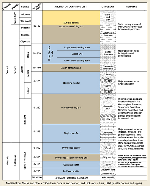
Ground water is the principal source of water for irrigation, industry, and domestic uses in the southern Flint River Basin. Aquifers consist of layers of sand or limestone that are separated by confining units of low permeability. Discharge of water from the aquifers to wetlands, streams, and springs is vital to maintain wildlife and plant species.


Introduction | Map | Hydrogeology | Economics | Water Quality | Ground-Water/Surface-Water | Wildlife | Drought Protection Act | Protection | Flood Tracking | Timeline | References

Recent USGS publications on Georgia or Georgia Water-Resources Information

For more information, please contact webmaster-ga@usgs.gov.

Accessibility FOIA Privacy Policies and Notices

Take Pride in America home page. FirstGov button U.S. Department of the Interior | U.S. Geological Survey
URL: https://pubsdata.usgs.gov/pubs/gip/2006/04/htdocs/hydrogeo.html
Page Contact Information: Publications Team
Page Last Modified: Wednesday, 30-Nov-2016 12:11:32 EST