GROUND WATER ATLAS of the UNITED STATES
Kansas, Missouri, and Nebraska
HA 730-D
Surficial aquifer system
There are two different files for each illustration
- A 72 ppi GIF file, suitable for screen viewing is accessed through
the thumbnail image
- An eps file, suitable for downloading to be printed or edited is accessed
through the "eps file" link. Most files are Adobe Illustrator
6.0, exceptions are noted. These files have been compressed with GNU's
gzip utility. If your web browser defaults to a screen display of the file,
turn on the "Load to local disk" option before downloading. Download
and process these eps files as ascii, not binary.
Arkansas River Valley, Southwestern Kansas
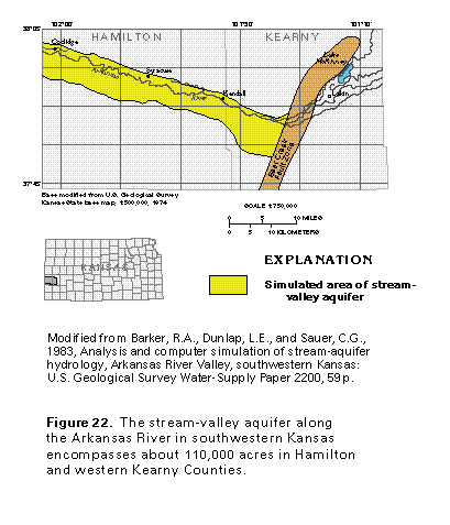
Figure 22 Map of stream-valley along the Arkansas River in southwestern
Kansas (17K)
 editable eps
file D022.eps.gz (50K compressed)
editable eps
file D022.eps.gz (50K compressed)
Figure 23 Saturated thickness of the stream-valley aquifer
(33K)
 editable eps file D023.eps.gz
(33K compressed)
editable eps file D023.eps.gz
(33K compressed)
Figure 24 Graph showing average monthly discharge of the
Arkansas River near Coolidge, Kansas (17K)
 editable eps file D024.eps.gz
(17K compressed)
editable eps file D024.eps.gz
(17K compressed)
Figure 25 Graph showing well discharge of the stream-valley
aquifer during the 1970's (17K)
 editable eps
file D025.eps.gz (33K compressed)
editable eps
file D025.eps.gz (33K compressed)
Figure 26 Map showing depth to water (33K)
 editable eps file D026.eps.gz
(50K compressed)
editable eps file D026.eps.gz
(50K compressed)
Figure 27 Diagramatic section showing the change in water
table due to pumping (17K)
 editable eps file D027.eps.gz
(33K compressed)
editable eps file D027.eps.gz
(33K compressed)
Figure 28 Graph showing river loss due to seepage to the
stream-valley aquifer (17K)
 editable eps file D028.eps.gz
(17K compressed)
editable eps file D028.eps.gz
(17K compressed)
 editable eps
file D022.eps.gz (50K compressed)
editable eps
file D022.eps.gz (50K compressed) 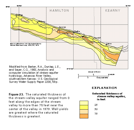 editable eps file D023.eps.gz
(33K compressed)
editable eps file D023.eps.gz
(33K compressed) 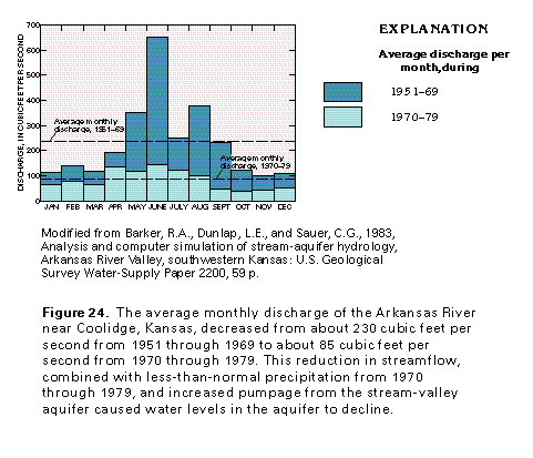 editable eps file D024.eps.gz
(17K compressed)
editable eps file D024.eps.gz
(17K compressed) 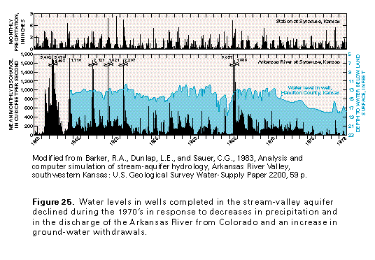 editable eps
file D025.eps.gz (33K compressed)
editable eps
file D025.eps.gz (33K compressed) 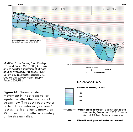 editable eps file D026.eps.gz
(50K compressed)
editable eps file D026.eps.gz
(50K compressed) 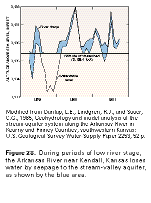 editable eps file D028.eps.gz
(17K compressed)
editable eps file D028.eps.gz
(17K compressed)