GREAT PLAINS AQUIFER SYSTEM
INTRODUCTION
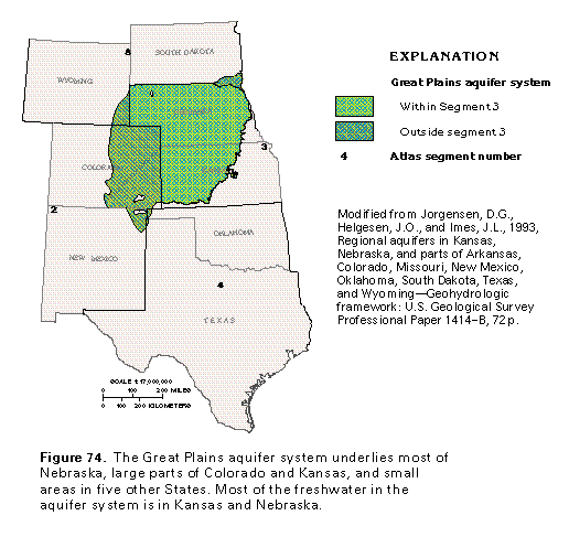
The Great Plains aquifer system underlies most of Nebraska, about one-half of Kansas, the eastern one-third of Colorado, and small parts of New Mexico, Oklahoma, Texas, South Dakota, and Wyoming (fig. 74). The rocks that compose the aquifer system extend northward into Segment 8 of this Atlas, where they mostly contain saline water, and equivalent rocks extend still further northward into western Canada. The aquifer system has been studied in detail, however, only in the area shown in figure 74, where it extends for about 170,000 square miles. Although the Great Plains aquifer system is extensive in Segment 2 of this Atlas, it contains primarily saline water there, along with some brine, oil, and gas, and is accordingly not discussed in detail in the chapter which describes that segment. The maps and descriptions presented in this chapter apply to the parts of the aquifer system that are in Kansas and Nebraska.
The Great Plains aquifer system is named for the Great Plains Physiographic Province, which is a vast, rolling plain that slopes eastward for several hundred miles from the front of the Rocky Mountains. The water-yielding rocks of the aquifer system are sandstone; confining units in the system consist of siltstone and shale. Water has been produced from the uppermost part of the aquifer system for many years; more than 1,000 flowing wells were reported to produce water from the aquifer system in 1905. In the early 1900's, the uppermost aquifer of the system was named the Dakota aquifer and was described as a classic artesian system. More recent studies have shown that the flow system of this aquifer is more complex than was originally thought. Likewise, the stratigraphy of the rocks that form the aquifer is complex. It is now known to be an oversimplification to refer to the aquifer simply as the "Dakota aquifer," and it has accordingly been renamed.
HYDROGEOLOGIC UNITS
The rocks that contain the Great Plains aquifer system were deposited during the early part of the Cretaceous Period and reflect transgressions and regressions of the Cretaceous sea. The thickness of the basal part of the aquifer system varies because of the relief of the pre-Cretaceous erosional surface. Local stratigraphy is complex because numerous oscillations of the sea resulted in repeated, rapid shifts from marine to marginal marine to nonmarine depositional environments. These environmental changes are reflected in abrupt changes in the texture of the sediments. Sand bodies are typically linear, lenticular, or sinuous, which indicates that they were deposited in deltaic, shoreline, or fluvial environments.
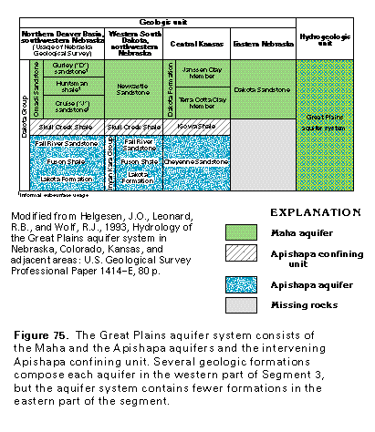
Regionally, the Great Plains aquifer system is characterized by two sandstone aquifers separated by a shale confining unit (fig. 75). The aquifer system contains more geologic formations and is more complex in southwestern Nebraska, where it is extremely thick, than to the east in Nebraska and Kansas, where it is thinner. In places, both aquifers are subdivided by shale beds that form local confining units. The Great Plains confining system, which consists mostly of thick layers of Upper Cretaceous shale, overlies the Great Plains aquifer system in most places. The aquifer system is confined below by a thick sequence of shale, limestone, sandstone, and anhydrite beds of Jurassic to Late Mississippian age. This underlying sequence of confining beds is called the Western Interior Plains confining system.
The upper aquifer of the Great Plains aquifer system is called the Maha aquifer. This aquifer was formerly called the Dakota aquifer from the Dakota Sandstone, which is a prominent part of the aquifer. The Maha is the best known and most used part of the aquifer system. The correlation chart (fig. 75) shows the different usage of the term "Dakota" in different places throughout the extent of the aquifer system. In eastern Nebraska and Kansas, the name "Dakota Formation" applies only to the upper aquifer of the system. In southwestern Nebraska, the Dakota is considered to be a stratigraphic group that includes all Lower Cretaceous rocks and the lower part of Upper Cretaceous rocks, and consists of four sandstone aquifers and three confining units. In Kansas, the term "Dakota aquifer" refers to the entire Great Plains aquifer system. Because of the multiple meanings of the term "Dakota" as applied to either geologic units or hydrogeologic units, confusion is avoided by assigning a new name, the "Maha aquifer," to the upper aquifer. Likewise, it is inexact to apply the formerly used name "Cheyenne Sandstone aquifer" to the lower aquifer of the Great Plains aquifer system. Accordingly, this lower aquifer has been renamed the "Apishapa aquifer." The Maha aquifer is separated from the Apishapa aquifer in most places by the Apishapa confining unit, which consists of the Kiowa and the Skull Creek Shales.
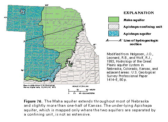
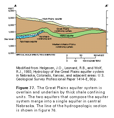
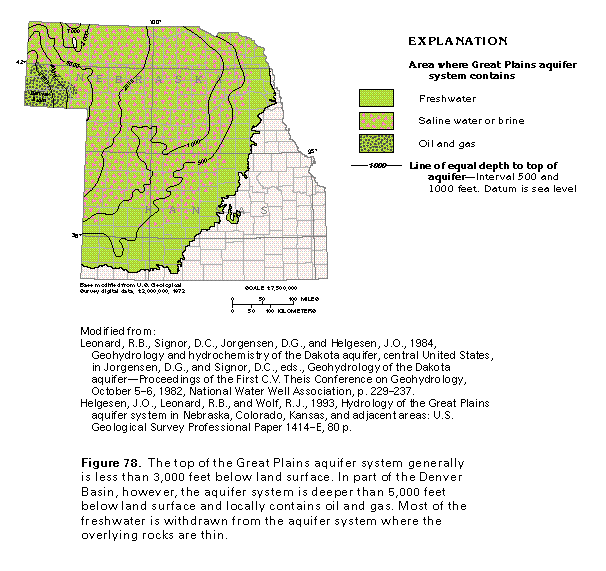
The Maha and the Apishapa aquifers consist of loosely cemented, medium- to fine-grained sandstone. The Apishapa confining unit that separates the aquifers consists of slightly permeable shale. The Maha aquifer is more extensive than the Apishapa aquifer (fig. 76); where the Apishapa confining unit pinches out, the two aquifers are in direct contact and are considered to be part of the Maha aquifer (fig. 77). In western Nebraska, both aquifers are downwarped to depths of more than 5,000 feet below land surface in part of the Denver Basin (fig. 78), where parts of the Great Plains aquifer system contain brine, oil, and gas. In eastern Nebraska and most of Kansas, the aquifer system is buried to depths of 1,000 feet or less below land surface.
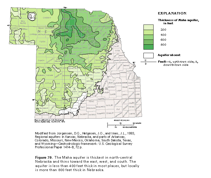
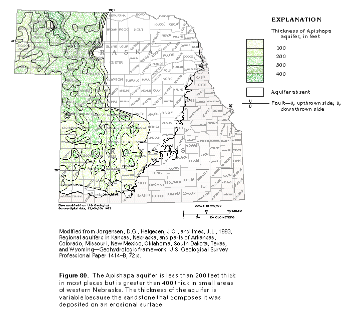
The Maha aquifer is much thicker than the Apishapa aquifer in most places. The thickness of the Maha aquifer generally is about 200 to 300 feet in western Nebraska and most of Kansas, but locally the aquifer is more than 800 feet thick in north-central Nebraska (fig. 79). The greatest thicknesses of the Maha aquifer are just east of where the Apishapa confining unit pinches out and the sandstones of the underlying Apishapa aquifer merge with those of the Maha aquifer. The Apishapa aquifer typically is between 100 and 200 feet thick (fig. 80) but locally is more than 400 feet thick in west-central Nebraska. The thickness of the Apishapa aquifer varies because the sedimentary rocks that compose the aquifer were deposited on an irregular erosional surface.
GROUND-WATER FLOW
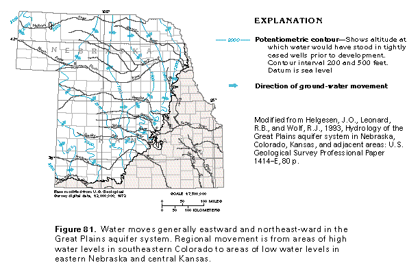
The regional movement of water in the Great Plains aquifer system in Segment 3 can be inferred from a map of the potentiometric surface of the aquifer system (fig. 81). Water levels in the aquifer system are highest in southwestern Kansas and northwestern Nebraska. Water moves generally eastward and northeastward from recharge areas in southeastern Colorado toward discharge areas in central Kansas, eastern Nebraska, and along the Missouri River in northeastern Nebraska. In its central parts, the aquifer system typically is overlain by a thick confining system, and the hydraulic gradient is flat. Water in the aquifer system in these places moves sluggishly. Near the eastern limit of the aquifer system, the hydraulic gradient becomes steeper, which indicates a more dynamic ground-water flow system.
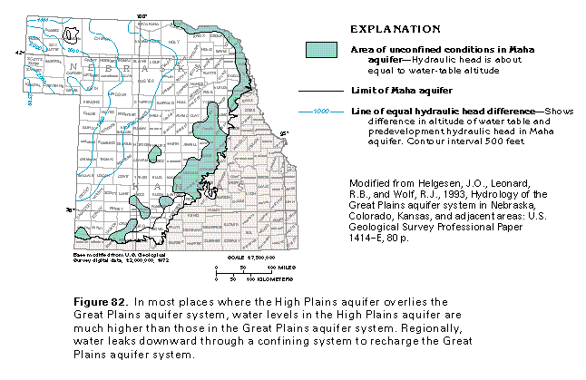
Much of the recharge to the aquifer system is from precipitation that falls directly on aquifer outcrop areas in southern and southeastern Colorado and east-central Kansas. Some recharge, however, enters the aquifer system as downward leakage through the overlying Great Plains confining system. The High Plains aquifer overlies this confining system, and the hydraulic gradient is downward from the High Plains aquifer to the Great Plains aquifer system in most places (fig. 82). For example, in the southwestern part of the Nebraska panhandle, the water table in the High Plains aquifer is more than 2,500 feet higher than the hydraulic head in the Great Plains aquifer system. In many places near the eastern limit of the Great Plains aquifer system, however, water levels in the High Plains aquifer and the Great Plains aquifer system are about equal. Locally, the hydraulic gradient is reversed, and discharge takes place by upward leakage from the Great Plains aquifer system to the High Plains aquifer. Most discharge from the Great Plains aquifer system is by upward leakage, but some discharge is as base flow to streams in aquifer outcrop areas.
The Great Plains aquifer system is mostly confined above by the Great Plains confining system and below by the Western Interior Plains confining system. Movement of water through the confined parts of the aquifer system is very slow and is estimated to be 10 feet per year or less. Flow is more rapid in places where the aquifer system crops out or the overlying confining system is thin. The presence of oil, gas, and brine in deeply buried parts of the aquifer system, such as the Denver Basin, indicates that the water in such places is virtually stagnant.
Most of the data available for the water-yielding capability of the Great Plains aquifer system are from the Maha aquifer. Sparse data from the deeper Apishapa aquifer indicate that the two aquifers have similar hydraulic properties, which show similar trends. Most of the porosity in the aquifer system is intergranular; that is, it consists of pore spaces between individual sand grains. Joints, fractures, and bedding planes exist locally in the sandstones, but most of the water moves through the intergranular pore spaces. Sandstone porosity in the Great Plains aquifer system generally decreases as the depth of burial of the aquifer system increases because the sandstone has compacted where it is buried beneath thousands of feet of overlying rocks. The compaction has reduced the percentage of pore space in the sandstone from more than 30 percent where overlying rocks are thin to less than 10 percent where the aquifer system is deeply buried. This reduction in pore space not only reduces the capacity of the aquifer to store water, but also its capability to transmit water.
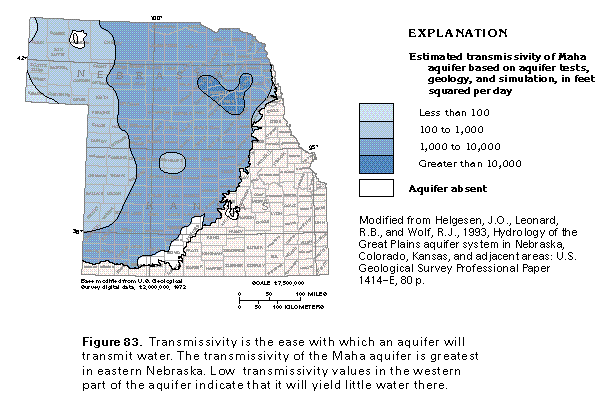
Transmissivity, or the capacity of an aquifer or aquifer system to transmit water, is one way to measure the ease with which ground water moves. The greater the transmissivity of an aquifer, the more readily water moves through it, and the greater the chances of obtaining large well yields from the aquifer. The distribution of the estimated transmissivity of the Maha aquifer is shown in figure 83. The transmissivity of the aquifer is greater in its eastern parts, and the larger transmissivity values (1,000 to more than 10,000 feet squared per day) coincide with places where the aquifer is thickest. The transmissivity values in western Nebraska locally are less than 100 feet squared per day where the aquifer is deeply buried and compacted in part of the Denver Basin. Reported yields of wells completed in the Maha aquifer in eastern Nebraska and central Kansas commonly exceed 50 gallons per minute and locally are as much as 1,000 gallons per minute. These large-yield areas coincide with places where the transmissivity of the aquifer is high.
GROUND-WATER QUALITY
The chemical character of water in the Great Plains aquifer system is determined by many factors. Some of or all the following factors determine the ground-water chemistry: the mineral content of the soil or aquifer material through which the water has passed; the rate of movement of the water; the length of time the water remains in the aquifer; the chemistry of water trapped during sediment deposition; diagenesis, or the chemical and physical changes that take place in aquifer sediments after they are deposited; and mixing of the water with water in adjacent hydrogeologic units or from the land surface.
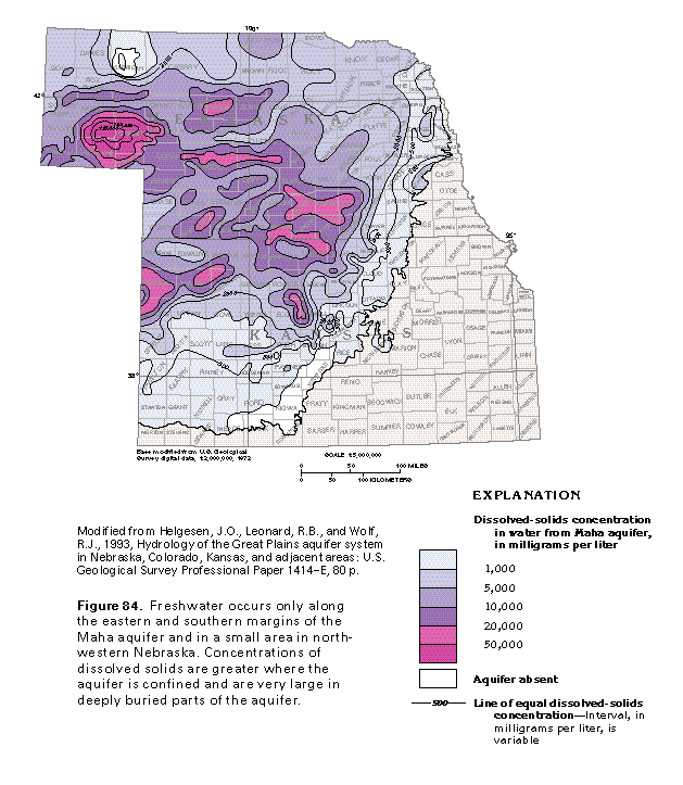
Concentrations of dissolved solids in water from the Maha aquifer are mapped in figure 84. The aquifer contains freshwater only near its southern and eastern margins and in a small area in northwestern Nebraska. These are places where the overlying confining unit is thick and represent areas of aquifer recharge or discharge; the flow system is accordingly dynamic, and mineralized water can be readily flushed from the aquifer. Also, the quartz sand that composes most of the aquifer is not readily dissolved; this condition leads to small dissolved-solids concentrations in the ground water.
Water that contains dissolved-solids concentrations of between 1,000 and 10,000 milligrams per liter is considered to be slightly to moderately saline. Such water is characteristic of much of the Great Plains aquifer system and results from incomplete flushing of highly mineralized water by a sluggish flow system. Some of the mineralized water has leaked upward from underlying Permian rocks that contain halite and evaporite minerals.
In places where the Maha aquifer is deeply buried, it locally contains water with dissolved-solids concentrations of greater than 125,000 milligrams per liter (fig. 84). Such excessively large concentrations result from increased mineralization of saline water, which was trapped when the sandstones were deposited, by mixing with brine. The brine might have formed in barred basins into which seawater periodically spilled and became concentrated by evaporation, or it might have migrated into the aquifer in water that moved through and partially dissolved nearby salt or evaporite deposits. Concen-trations of dissolved solids that range from 10,000 to about20,000 milligrams per liter are common in water from the central and east-central parts of the aquifer. Concentrations of this magnitude can result from the combination of incomplete flushing and the upward migration of highly mineralized water from underlying Permian rocks.
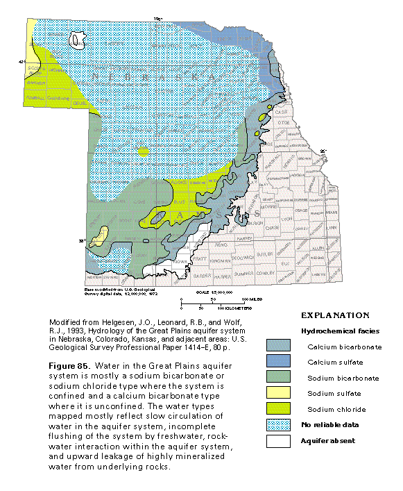
Ground water can be classified into hydrochemical facies on the basis of the dominant cations and anions in the water. To demonstrate the classification used, a sodium chloride water is one in which sodium ions account for more than 50 percent of the total cations in the water, and chloride ions account for more than 50 percent of the total anions. The distribution of hydrochemical facies in water from the Great Plains aquifer system is shown in figure 85. In many artesian flow systems, the water changes progressively from a calcium bicarbonate type in upgradient recharge areas to a sodium chloride type in deep, confined parts of the flow system. This is not the case with the Great Plains aquifer system because the distribution of hydrochemical facies is more complex (fig. 85). Calcium bicarbonate type water mostly is in a narrow band along the eastern and southern limits of the aquifer system. Where the aquifer system is confined, it mostly contains sodium bicarbonate or sodium chloride type waters. These hydrochemical facies are in places where mineralized water in the aquifer system has not been completely flushed by circulating freshwater and where underlying saline water leaks upward faster than it can be flushed. Some of the sodium bicarbonate water may be the result of ion exchange of calcium for sodium on the surface of clay or other sodium-rich minerals in the rocks of the aquifer system. The calcium sulfate type water in northeastern Nebraska results from the upward leakage of mineralized water from underlying rocks that contain anhydrite and gypsum. The leakage is thought to take place along fractures and faults. In summary, incomplete flushing, slow circulation through most of the aquifer system, rock-water interactions in the aquifer system, and mixing of highly mineralized waters from adjacent rocks are the processes that produce the observed distribution of hydrochemical facies.
FRESH GROUND-WATER WITHDRAWALS
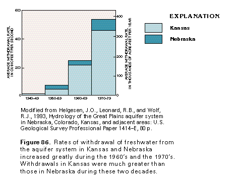
Freshwater is withdrawn from the Great Plains aquifer system in Kansas and Nebraska mostly along the southern and eastern margins of the aquifer. These are the parts of the aquifer system that are nearest to land surface and contain most of the freshwater. Although development of the aquifer system began in the early 1900's and moderate amounts of water were withdrawn from the aquifer system during the 1940's and the 1950's, it was not until the 1960's that withdrawals were significant (fig. 86). Estimated withdrawals from the aquifer system in Kansas and Nebraska during the 1970's were at a rate of about 390,000 acre-feet per year, which is almost eight times the rate of withdrawal during the 1950's. The distribution of withdrawals has changed with time. During the 1950's, withdrawals in Kansas and Nebraska were about equal; during the 1960's, however, withdrawals increased greatly in Kansas, while withdrawals in Nebraska remained about the same as in the 1950's. During the 1970's, withdrawals increased greatly in both States.
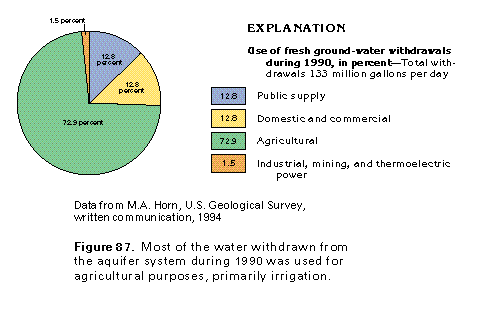
Total fresh ground-water withdrawals from the Great Plains aquifer in Kansas and Nebraska were about 133 million gallons per day during 1990 (fig. 87). About 73 percent of the water withdrawn, or about 97 million gallons per day, was used for agricultural purposes, primarily irrigation. About 17 million gallons per day was withdrawn for public supply purposes, and the same amount was withdrawn for domestic and commercial purposes. About 2 million gallons per day was pumped for industrial, mining, and thermoelectric power uses.