OZARK PLATEAUS AQUIFER SYSTEM
INTRODUCTION
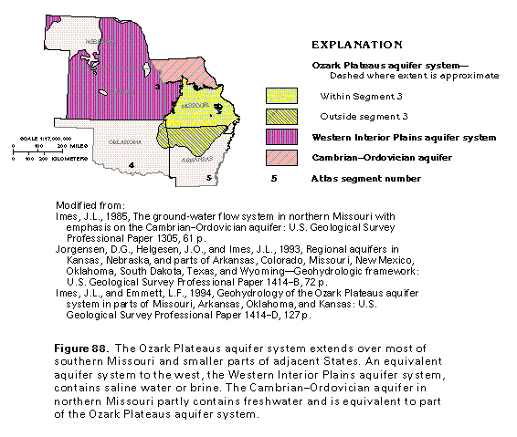
The Ozark Plateaus aquifer system contains most of the freshwater in the aquifers that consist of Mississippian and older rocks in Segment 3. The aquifer system underlies most of southern Missouri and a small part of extreme southeastern Kansas in this segment; it also underlies a large area in northwestern Arkansas and a small part of northeastern Oklahoma (fig. 88). The Arkansas part of the aquifer system is discussed in detail in the chapter of this Atlas that describes Segment 5, and the Oklahoma part is discussed briefly in the chapter that describes Segment 4.
Rocks equivalent to parts of the Ozark Plateaus aquifer system locally contain freshwater in parts of northeastern Missouri and are called the Mississippian and the Cambrian-Ordovician aquifers. Equivalent carbonate rocks to the west and northwest that contain saline water or brine have been named the "Western Interior Plains aquifer system" (fig. 89). The water-yielding rocks in the Ozark Plateaus aquifer system and equivalent beds are mostly limestones and dolomites, but some sandstones are productive aquifers. Confining units within the aquifer system and its equivalents are shale or dolomite. The lithology of the individual aquifers and confining units and their hydraulic character are consistent over large areas.
Ground water in the aquifer system locally moves from topographically high recharge areas to surface streams. Regional movement is northwestward, eastward, and southward from the St. Francois Mountains and other topographically high areas in southern Missouri. The water moves upward at the transition zone between the Ozark Plateaus and the Western Interior Plains aquifer systems and discharges either to streams as base flow or to shallow stream valley alluvial aquifers.
RELATION TO ADJACENT AQUIFERS AND AQUIFER SYSTEMS
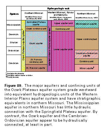
The Ozark Plateaus aquifer system consists of three aquifers separated by two confining units (fig. 89), all of which grade laterally westward into equivalent hydrogeologic units that are part of the Western Interior Plains aquifer system. Sparse information indicates that the rocks of the St. Francois confining unit, which is the lowermost confining unit within the Ozark Plateaus aquifer system, are thin or absent in the area of the Western Interior Plains aquifer system. The combined Ozark and St. Francois aquifers of the Ozark Plateaus aquifer system are thus considered to be equivalent to the unnamed lower aquifer units of the Western Interior Plains aquifer system. The Ozark confining unit and the Springfield Plateau aquifer of the Ozark Plateaus aquifer system are equivalent to the confining unit and upper aquifer unit (both unnamed) of the Western Interior Plains aquifer system, respectively.
Hydrogeologic units of the Ozark Plateaus aquifer system also are equivalent to aquifers and confining units north of the Missouri River in Missouri (fig. 89). The Springfield Plateau aquifer is stratigraphically equivalent to the Mississippian aquifer of northern Missouri, but limited information indicates that these aquifers have little or no hydraulic connection. Part of the Ozark aquifer is equivalent to the Cambrian-Ordovician aquifer of northern Missouri, and these two aquifers are considered to be hydraulically connected in places. Upper Devonian and Lower Mississippian rocks compose a confining unit in the Ozark Plateaus aquifer system in southern Missouri, and equivalent rocks are part of a thick confining unit in northern Missouri. The lowermost aquifer of the Ozark Plateaus aquifer system is equivalent to a poorly known, unnamed minor aquifer in northern Missouri.
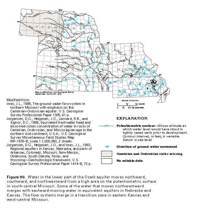
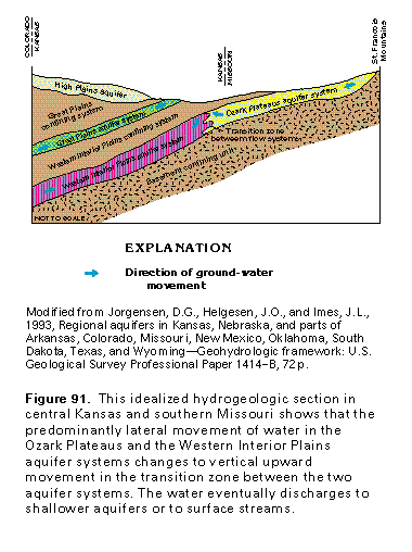
The general direction of ground-water movement in the lower part of the Ozark aquifer and its equivalents can be inferred from a map of the potentiometric surface of these aquifers (fig. 90). Water in Cambrian and Ordovician rocks in southern Missouri moves northward, southward, and northwestward from a ground-water divide in south-central Missouri. Water in the Western Interior Plains aquifer system generally moves southeastward and eastward; locally, in southwestern Kansas, the water moves northward. Little or no water leaks upward across the thick, effective Western Interior Plains confining system that overlies most of the Western Interior Plains aquifer system. Lateral flow in the two aquifer systems merges in a northeast-trending transition zone in eastern Kansas and west-central Missouri. This transition zone, which separates the regional ground-water flow systems (fig. 91), coincides with a low area on the potentiometric surface and with a topographically low area at the land surface. Ground water in the transition zone moves mostly upward, and discharges either to streams as base flow or to shallow, unconfined, stream-valley alluvial aquifers. Water that moves northward in the lower part of the Ozark aquifer discharges mostly to the Missouri River along a low area of the potentiometric surface parallel to the river (fig. 90). The Missouri River is likewise a discharge area for water that moves southward in the Cambrian-Ordovician aquifer, which is located north of the river. Locally, water in the Ozark and Cambrian-Ordovician aquifer system moves eastward toward the Mississippi River, which is the largest and most deeply incised regional drain in the area.
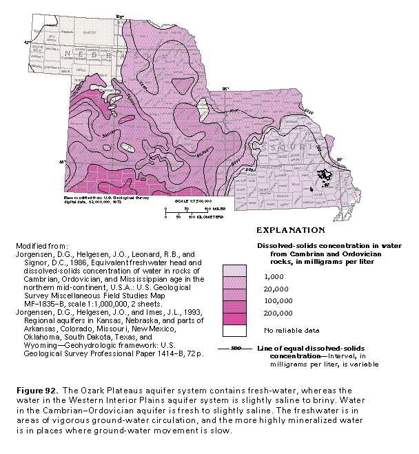
Water in the lower part of the Ozark aquifer is fresh in most of the southern one-half of Missouri and adjacent areas (fig. 92). Water in the equivalent Cambrian-Ordovician aquifer is fresh in a large area in east-central Missouri but is slightly to moderately saline in northern and northwestern Missouri where the aquifer is overlain by a thick confining unit and ground-water flow in the aquifer is sluggish. Water in the Western Interior Plains aquifer system is slightly saline or a brine (fig. 92) and locally contains dissolved-solids concentrations of more than 200,000 milligrams per liter in deeply buried parts of the aquifer system, such as those along the Kansas-Oklahoma State line. Compaction due to deep burial reduces the porosity and permeability of the aquifer system, and the hydraulic gradient of the system is small. Movement of water in the deep parts of the aquifer system is, therefore, very slow, and highly mineralized water has not been flushed from these parts of the system. The transition zone between the freshwater of the Ozark Plateaus aquifer system and the more mineralized water of the Western Interior Plains aquifer system is narrow and is reflected by an abrupt westward increase in dissolved solids in the ground water. Some of the mineralized water discharges upward to saline springs, such as those in Saline County, Missouri, and some locally discharges to the Osage River in Henry County, Missouri. This discharge of saline water indicates that water moves eastward in the Western Interior Plains aquifer system.
HYDROGEOLOGIC UNITS
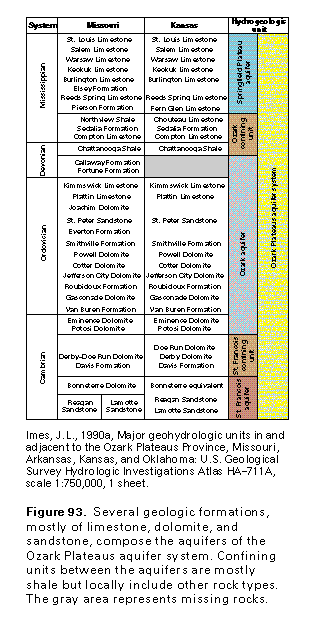
Several geologic formations compose each of the three aquifers and two intervening confining units of the Ozark Plateaus aquifer system. These formations are grouped into the hydrogeologic units that make up the aquifer system in Missouri and Kansas (fig. 93). The top and bottom of each hy-drogeologic unit coincide with the top or bottom of a sequence of geologic units, although the number of geologic units in each aquifer and confining unit varies from place to place. The water-yielding formations are mostly limestone and dolomite but locally include sandstone and chert. The confining units that separate the aquifers primarily are shale but also consist of limestone, dolomite, and sandstone, all of which have minimal permeability. For example, the St. Francois confining unit consists mostly of dolomite. Locally, shale beds within the aquifers form confining units of limited extent.
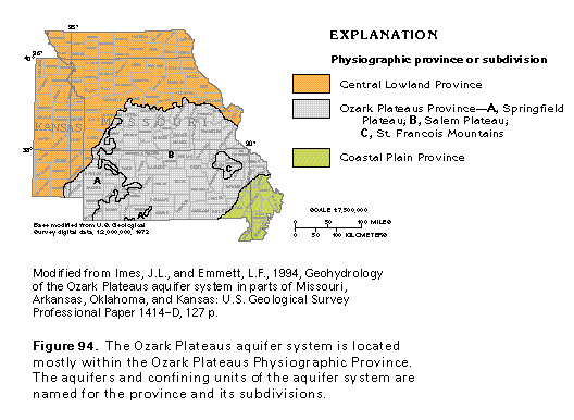
The aquifers in the Ozark Plateaus aquifer system have been named for geographic or physiographic features (fig. 94). From shallowest to deepest, the three aquifers are the Springfield Plateau aquifer, which was named for a physiographic feature in western Missouri and adjacent areas; the Ozark aquifer, which was named for the rolling uplands that compose most of the Ozark Plateaus Physiographic Province in central Missouri; and the St. Francois aquifer, which was named for the St. Francois Mountains in eastern Missouri. Confining units in the system are named the same as the aquifers they overlie; for example, the St. Francois aquifer is overlain by the St. Francois confining unit.
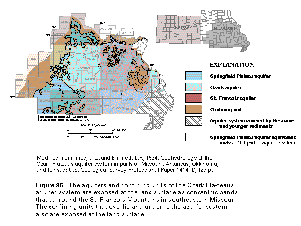
The aquifers and confining units of the Ozark Plateaus aquifer system are exposed as a sequence of concentric bands that are centered around the Precambrian rocks that are exposed in the St. Francois Mountains (fig. 95). These Precambrian igneous and metamorphic rocks form the basement confining unit, which is the lower confining unit of the Ozark Plateaus aquifer system. Exposures of the St. Francois aquifer surround this confining unit and are, in turn, surrounded by a band of the overlying St. Francois confining unit. The rocks that compose the Ozark aquifer crop out over more than one-half of southern Missouri and in a large part of northern Arkansas. The thick, widespread Ozark aquifer is by far the most important aquifer of the Ozark Plateaus aquifer system; the equivalent Cambrian-Ordovician aquifer north of the Missouri River is also an important source of water. The thin Ozark confining unit overlies the Ozark aquifer and crops out as a narrow band that separates the Ozark aquifer from the overlying Springfield Plateau aquifer. A thick sequence of rocks with minimal permeability, which is called the Western Interior Plains confining system, overlies and effectively confines the Springfield Plateau aquifer west of the outcrop area of the aquifer. The Ozark Plateaus aquifer system is covered in southeastern Missouri by Mesozoic and younger rocks and deposits that are part of the Mississippi embayment aquifer system or the Mississippi River Valley alluvial aquifer.
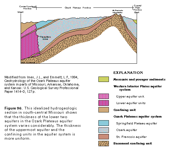
Variations in the thickness and extent of the aquifers and confining units of the Ozark Plateaus aquifer system and their equivalents are shown in figure 96. The thickness of the Springfield Plateau aquifer is uniform slightly to the west of its outcrop area, but the equivalent upper aquifer unit of the Western Interior Plains aquifer system thins westward where it is covered by the Western Interior Plains confining system. The Ozark aquifer thickens gradually westward and is more than 1,000 feet thick in central Missouri; the aquifer thickens more rapidly to the east of the St. Francois Mountains. The thickness of the St. Francois aquifer varies greatly because the rocks that compose this aquifer were deposited on an irregular erosional surface that was developed on Precambrian rocks of the basement confining unit. The thickness of the St. Francois and the Ozark confining units does not vary as much as that of the aquifers that they separate.
SPRINGFIELD PLATEAU AQUIFER
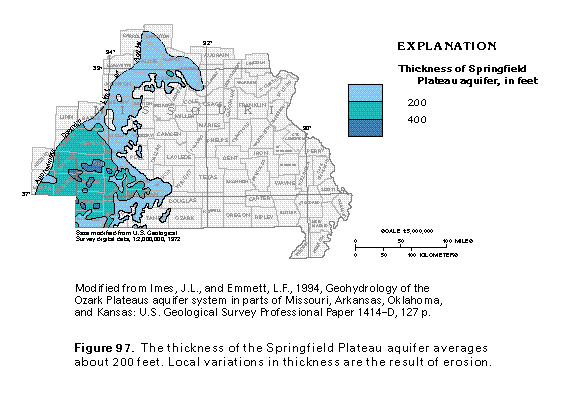
The Springfield Plateau aquifer is the uppermost aquifer of the Ozark Plateaus aquifer system and consists almost entirely of limestone of Mississippian age. The thickest and most productive water-yielding geologic formations included in the aquifer are the Burlington and the Keokuk Limestones (fig. 93). North of the Missouri River, the Burlington and the Keokuk Limestones also yield water but are considered to be a separate aquifer, the Mississippian aquifer. The thickness of the Springfield Plateau aquifer ranges from less than 200 to more than 400 feet (fig. 97) and averages about 200 feet. Locally, the aquifer is absent in the subsurface. The aquifer thins abruptly at the eastern edge of the Salem Plateau. Equivalent rocks in two small areas in St. Louis and Ste. Genevieve Counties, Missouri, are not considered to be part of the aquifer.
Most of the water in the Springfield Plateau aquifer occurs in and moves through secondary openings, such as fractures and bedding planes. The slightly acidic ground water that moves through these openings has dissolved part of the limestone and has resulted in a network of solution channels. This dissolution activity is reflected at the land surface by springs, caves, and sinkholes, and by sparse surface drainage. These features are characteristic of a type of topography called karst topography, which commonly is developed in areas underlain by limestone.
Recharge to the Springfield Plateau aquifer is mostly from precipitation on outcrop areas of the aquifer. After the recharge water percolates downward to the water table, most of it moves laterally along short flow paths to discharge as base flow to nearby streams. Some of the water follows flow paths of intermediate length and discharges to large streams, and a small part of the recharge moves laterally into deep, confined parts of the aquifer. A small amount of recharge to the Springfield Plateau aquifer is by upward leakage of water from the deeper Ozark aquifer in places where the hydraulic head of the Ozark aquifer is higher than that of the Springfield Plateau aquifer. In much of the outcrop area of the Springfield Plateau aquifer, however, water levels in this aquifer are higher than those in the Ozark aquifer, and water leaks downward to recharge the Ozark aquifer. Upward and downward leakage take place through the Ozark confining unit that separates the Springfield Plateau and the Ozark aquifers.
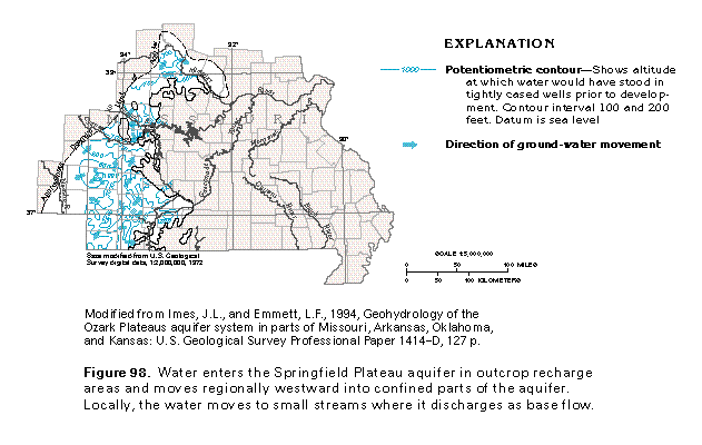
A map of the estimated potentiometric surface of the Springfield Plateau aquifer before development (fig. 98) shows that water in the aquifer moved mostly from local recharge areas to nearby surface drains. The configuration of the potentiometric surface contours is irregular because of the influ-ence of streams on the ground-water flow system. Where the aquifer is confined above by the Western Interior Plains confining system, the contours are smoother and only reflect the influence of large streams. The regional movement of water in the aquifer is westward.
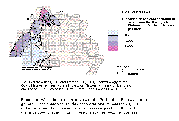
The chemical quality of water in the Springfield Plateau aquifer generally is suitable for most uses where the aquifer is unconfined or where the confining unit that overlies the aquifer is thin. The water commonly is a calcium bicarbonate type and is moderately hard. Dissolved-solids concentrations in water from the aquifer generally are less than 1,000 milligrams per liter except where the aquifer is confined (fig. 99). Dissolved-solids concentrations increase rapidly downgradient where the aquifer becomes confined. Concentrations of sulfate generally are small in water from the aquifer except in the Tri-State lead-zinc mining district of southwestern Missouri, southwestern Kansas, and northeastern Oklahoma where concentrations of more than 500 milligrams per liter are reported near some mining areas. These large concentrations result from leaching of the sulfide minerals that contain the lead and zinc.
Most of the water withdrawn from the Springfield Plateau aquifer is used for domestic and stock-watering supplies. Yields of wells completed in the aquifer generally are less than 20 gallons per minute.
OZARK CONFINING UNIT
The Ozark confining unit underlies the Springfield Plateau aquifer and hydraulically separates this aquifer from the deeper Ozark aquifer. The Ozark confining unit consists mostly of shale but locally includes limestone of minimal permeability. The confining unit generally is less than 100 feet thick except in small areas. Where the shale content of the confining unit is greater, the confining unit can more effectively retard the vertical movement of water between the Springfield Plateau and the Ozark aquifers. North of the Missouri River, rocks equivalent to the Ozark confining unit separate the Mississippian and the Cambrian-Ordovician aquifers.
OZARK AQUIFER
The Ozark aquifer is the middle aquifer of the Ozark Plateaus aquifer system and consists of numerous geologic formations that range in age from Devonian to Cambrian (fig. 93). The rocks of the aquifer are mostly dolomite and limestone, but some beds of sandstone, chert, and shale are included in it. The Ozark aquifer is the primary source of water in the Ozark Plateaus Physiographic Province from which it is named. The aquifer provides water for municipal, industrial, and domestic supplies. The main water-yielding formations in the Ozark aquifer are the Upper Cambrian Potosi Dolomite, the Lower Ordovician Gasconade Dolomite, and the Roubidoux Formation. The Potosi Dolomite is the most permeable of these three formations. North of the Missouri River, rocks that are equivalent to the Ozark aquifer are called the Cambrian-Ordovician aquifer. Like the Ozark aquifer, the Cambrian-Ordovician aquifer consists mostly of dolomite and limestone; however, it also includes beds of sandstone and shale. The Upper Cambrian Potosi and the Eminence Dolomites are the main water-yielding formations in the Cambrian-Ordovician aquifer, but the Lower Ordovician Gasconade Dolomite and locally the Middle Ordovician St. Peter Sandstone are important sources of water. Most wells completed in the Cambrian-Ordovician aquifer are open to more than one water-yielding unit. The Ozark and the Cambrian-Ordovician aquifers are mapped together in this report.
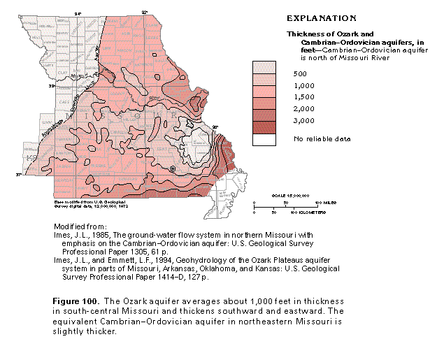
The Ozark aquifer underlies most of Missouri south of the Missouri River, and the Cambrian-Ordovician aquifer underlies the eastern one-half of Missouri north of that river (fig. 100). The Ozark aquifer is less than 1,000 feet thick throughout the Salem Plateau but thickens to more than 3,000 feet in southeastern Missouri just north and east of the bootheel. The Ozark aquifer pinches out against the flanks of the St. Francois Mountains, and its thickness is irregular where it has been eroded in outcrop areas. Caves, sinkholes, and other types of solution features characteristic of karst topography have developed on the carbonate-rock units that compose the aquifer. North of the Missouri River, the thickness of the Cambrian-Ordovician aquifer averages about 1,200 feet but is locally greater than 1,800 feet. Carbonate rocks equivalent to the Cambrian-Ordovician aquifer in northwestern Missouri are deeply buried and contain saline water.
Recharge to the Ozark aquifer is mostly from precipitation on aquifer outcrop areas. Small volumes of water recharge the aquifer by downward leakage from the shallower Springfield Plateau aquifer. Most ground-water flow in the shallow part of the Ozark aquifer moves from topographically high recharge areas along short flow paths to discharge as base flow to nearby streams. The shallow flow system is accordingly con-trolled mostly by topography. The ground water mostly occurs in and moves through fractures and bedding planes in carbonate rocks. These openings have been enlarged by dissolution of the carbonate rocks and have been reported at depths of as great as 1,500 feet below land surface. Where sinkholes have formed from dissolution of the carbonate rocks, water that runs over the land surface may enter the sinkholes and large volumes of recharge can enter the aquifer in this manner. Recharge to the equivalent Cambrian-Ordovician aquifer likewise is mostly from precipitation on aquifer outcrop areas, but small amounts of recharge enter this aquifer by downward leakage of water from the overlying Mississippian aquifer.
Discharge from the Ozark and the Cambrian-Ordovician aquifers is mostly to streams in aquifer outcrop areas. Some water follows flow paths of intermediate length and discharges to regional drains, such as the Missouri and the Mississippi Rivers. A small volume of water leaks upward from the Ozark aquifer and locally discharges to the overlying Springfield Plateau aquifer. In southeastern Missouri, a small volume of water discharges from the Ozark aquifer to the Mississippi River Valley alluvial aquifer by upward leakage.
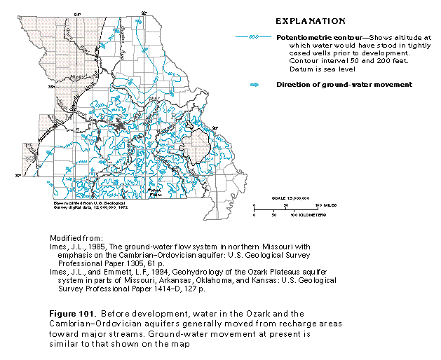
A map of the potentiometric surface of the Ozark and the Cambrian-Ordovician aquifers before development of the aquifers began (fig. 101) can be used to show the regional direction of ground-water movement in the aquifers. Water in the Ozark aquifer generally moved northward, westward, and southwestward from high areas on the potentiometric surface in south-central Missouri; some of the water moved toward the Mississippi and the Missouri Rivers. In the Cambrian-Ordovician aquifer, water moved along a gentle gradient from a high area on the potentiometric surface in north-central Missouri toward these same rivers. Movement of water in both aquifers at present is similar to movement before development except locally near well fields where the direction of ground-water flow is toward the pumping wells.
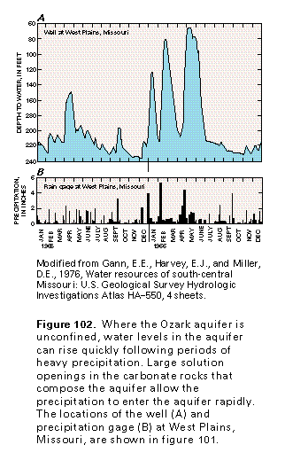
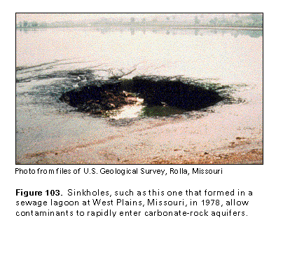
Water mostly is under unconfined conditions in the Ozark aquifer but is mostly under confined conditions in the Cambrian-Ordovician aquifer. Where the water is unconfined, water levels in the aquifer respond rapidly to changes in precipitation. For example, figure 102 shows changes in the water level in a well completed in the Potosi Dolomite (part of the Ozark aquifer) at West Plains in central Howell County, Missouri. Although this well is more than 1,300 feet deep, water-level rises of as much as 140 feet were recorded soon after several inches of precipitation fell. Solution openings in the carbonate rocks that compose the aquifer allow large volumes of water to enter the aquifer quickly, which accounts for the rapid rise in the water level. A sinkhole over one such solution opening in West Plains collapsed in 1978 (fig. 103). This sinkhole formed in a municipal sewage lagoon and allowed raw sew-age to enter the aquifer quickly and directly. Within a few days after the sinkhole collapsed, raw sewage was detected in nearby streams, and eventually traces of sewage were detected in a large spring 36 miles southwest of West Plains.
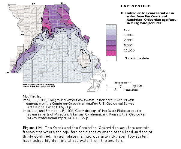
In most places, water in the Ozark aquifer is not highly mineralized, and the chemical quality of the water is suitable for most uses. Dissolved-solids concentrations in water from the Ozark and the Cambrian-Ordovician aquifers are mapped in figure 104. Concentrations in the Ozark aquifer are less than 1,000 milligrams per liter except in the westernmost parts of the aquifer and locally near the Mississippi River. In contrast, the equivalent Cambrian-Ordovician aquifer contains freshwater only in a small area in the southern part of the aquifer. In both aquifers, the water is fresh where the aquifer is unconfined or where the overlying confining unit is thin, and the ground-water flow system is vigorous. Water in the Ozark and the Cambrian-Ordovician aquifers generally is a calcium bicarbonate type but locally is a sodium bicarbonate type. Chloride and sulfate concentrations are less than 10 milligrams per liter in most places and the water is hard to moderately hard.
ST. FRANCOIS CONFINING UNIT
The St. Francois confining unit underlies the Ozark aquifer and separates it from the underlying St. Francois aquifer. The confining unit consists primarily of dolomite of minimal permeability but includes limestone, shale, and siltstone. Where the confining unit contains more shale and siltstone, it more effectively retards the movement of ground water between the two aquifers. The Davis Formation and the Derby and the Doe Run Dolomites are the geologic formations that compose the St. Francois confining unit. North of the Missouri River, the shaly Davis Formation is considered to be a confining unit, but the Derby and the Doe Run Dolomites yield small volumes of water.
The St. Francois confining unit crops out in a narrow band around the St. Francois Mountains. The confining unit is in the subsurface throughout the extent of the Ozark Plateaus aquifer system in Segment 3 except for local areas in western Missouri. The thickness of the eastern two-thirds of the confining unit generally is greater than 200 feet; in the western third, it is about 100 feet thick. However, the thickness of the unit is variable and locally is as great as 750 feet in northwestern Arkansas. Near the Mississippi River, the thickness of the confining unit is greater than 500 feet in several places.
ST. FRANCOIS AQUIFER
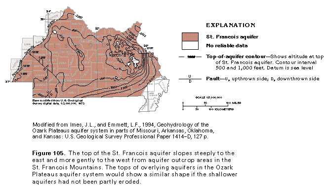
The St. Francois aquifer is the lowermost aquifer in the Ozark Plateaus aquifer system and is exposed at the land surface only in the St. Francois Mountains. Away from the mountains, the top of the aquifer slopes into the subsurface in all directions (fig. 105) and, within a short distance, it becomes buried beneath the more productive Ozark aquifer. The St. Francois aquifer is accordingly used as a source of supply only in and near the St. Francois Mountains. Several small faults cut the aquifer, especially in eastern Missouri, and locally displace its top. The top of the aquifer slopes steeply eastward from the St. Francois Mountains; westward, the slope is less steep, and the surface of the aquifer shows small hills and basins. The tops of the overlying aquifers and confining units in the Ozark Plateaus aquifer system would show the same overall shape as the top of the St. Francois aquifer if the overlying hydrogeologic units had not been partly eroded away.
The St. Francois aquifer consists of the Bonneterre Dolomite and the Lamotte Sandstone and its lateral equivalent, the Reagan Sandstone, all of which are of Cambrian age. The Lamotte Sandstone is the most productive of the geologic formations that compose the aquifer, and yields as high as 500 gallons per minute are reported from wells completed in this sandstone. Yields of wells completed in the Bonneterre Dolomite are reported to range between 10 and 50 gallons per minute. The water-yielding capability of the Reagan Sandstone is not well known. The Lamotte Sandstone and the Bonneterre Dolomite occur north of the Missouri River, but their water-yielding properties are not known; accordingly, no aquifer equivalent to the St. Francois aquifer is mapped there.
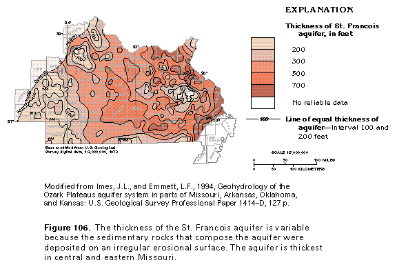
The thickness of the St. Francois aquifer generally is between 300 and 500 feet in south-central Missouri west of the St. Francois Mountains (fig. 106). The thickness of the aquifer is greater than 700 feet in several places to the north, east, and southeast of the mountains. The aquifer thins near its western and southern limits. The thickness of the St. Francois aquifer is irregular because the sedimentary rocks that compose the aquifer were deposited on a rugged erosional surface that was developed on Precambrian rocks of the basement confining unit. Places where the aquifer is missing in the subsurface may have been islands in the Cambrian sea where the aquifer sediments were deposited.
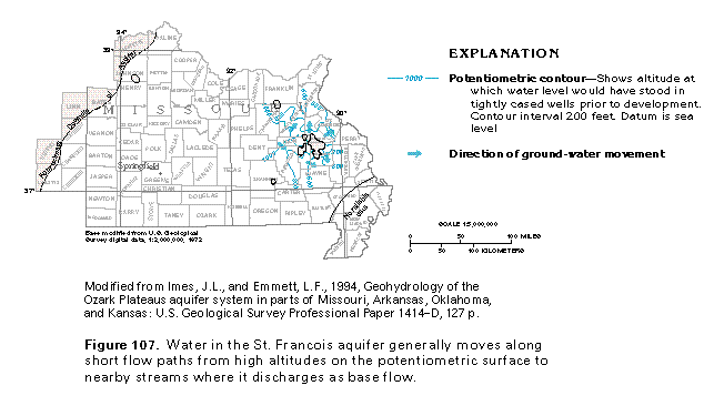
Water is withdrawn from the St. Francois aquifer only where the aquifer crops out or is buried to shallow depths. Little is known, therefore, about the regional ground-water flow system or the chemical quality of the water in the aquifer. Sparse water-level data (fig. 107) indicate that flow in the aquifer in and near outcrop areas primarily is controlled by topography. Water enters the aquifer as recharge from precipitation that falls on topographically high outcrop areas. Most of the water moves along short flow paths and discharges as base flow to nearby streams. A small volume of water moves along slightly longer flow paths into confined parts of the aquifer and discharges to shallower aquifers by upward leakage.
The chemical quality of the water in the St. Francois aquifer in and near the aquifer outcrop areas generally is suitable for most uses. The water is a calcium magnesium bicarbonate type with dissolved-solids concentrations reported to range between 200 and 450 milligrams per liter. Chloride concentrations in the water generally are less than 60 milligrams per liter, and sulfate concentrations are 150 milligrams per liter or less. Freshwater has been reported from the St. Francois aquifer as far west as Jasper and Pettis Counties, Missouri, which indicates a regional ground-water flow system in the aquifer.
SOLUTION FEATURES
Carbonate rocks, such as the limestone and dolomite that make up a large part of the Ozark Plateaus aquifer system, are readily dissolved where they are exposed at the land surface or are covered by a thin layer of soil. Small amounts of carbon dioxide are absorbed by precipitation that falls through the atmosphere. When the precipitation falls on the soil and percolates down through it to the water table, additional carbon dioxide is absorbed from decomposing organic matter in the soil. This absorption creates a weak carbonic acid, which partially dissolves the carbonate rocks. Initially, most of the rock material is dissolved along existing openings in the rock, such as joints and bedding planes. As the openings are enlarged, more of the acidic water is able to move more quickly through the aquifer; thus, the dissolution process and enlargement of the openings is accelerated. In some places, the openings are enlarged until streams flow in them and sediment transported in the streams erodes part of the rocks. If dissolution proceeds long enough, then karst topography, which is characterized by caves, sinkholes, and springs, develops on the carbonate rocks.
Sinkholes
Sinkholes are closed, usually circular depressions in the land surface. Sinkholes form by dissolution of bedrock and are common where carbonate rocks are at or near land surface. Voids develop where part of the carbonate rock is dissolved and the subsequent collapse of overlying material creates a sinkhole. Many sinkholes form slowly and expand gradually. Sudden collapse of surface material into a sinkhole sometimes occurs as a result of a natural decline of ground-water levels or human activities, such as the diversion of surface water, withdrawal of ground water, or construction of surface water impoundments or heavy structures on the land surface. Such sudden collapse is called catastrophic collapse and can result in severe damage to property or endanger human or animal life.
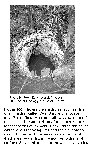
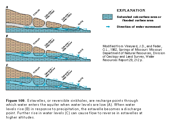
All or part of the flow of small streams might enter a sinkhole. Sinkholes commonly are connected to a subsurface network of caves, pipes, and other types of solution openings, all of which channel large volumes of ground water. Thus, sinkholes have important effects on ground and surface water. Large sinkholes may be occupied by ponds or lakes. Some sinkholes, such as the one shown in figure 108, are reversible; that is, water may flow into the sinkhole at times and out of it at other times. Such a sinkhole is called an estavelle. The relation of the water table to flow into and out of a reversible sinkhole is shown by the diagram in figure 109. During periods of normal or less-than-normal precipitation, water levels in the aquifer are low, and surface water enters the aquifer quickly and directly through the estavelles (fig. 109A). However, flow can be reversed (fig. 109B), and an estavelle can function as a spring when water levels in the aquifer rise during periods of excessive precipitation. As water levels continue to rise (fig. 109C), flow can be reversed in additional estavelles.
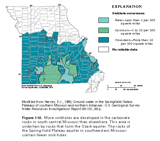
Sinkholes are abundant to common in much of the area where the carbonate rocks that compose the Ozark Plateaus aquifer system are at or near the land surface (fig. 110). Most of the areas where more than 10 sinkholes per 100 square miles have been mapped are underlain by the Ozark aquifer (compare figs. 95 and 110). Most sinkholes that have formed by sudden collapse are in the area underlain by the Ozark aquifer. However, a large area of abundant sinkholes near Springfield, Missouri, and smaller, isolated areas of abundant sinkholes to the north and west of Springfield are underlain by the Springfield Plateau aquifer.
Springs
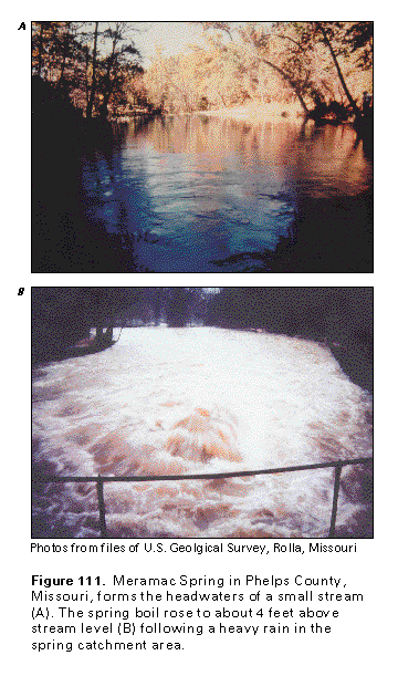
Springs are openings through which ground water discharges to the land surface. The sizes of the springs and the volume of water they discharge vary. Some springs are small seeps where only small volumes of water issue slowly from the aquifer; others, such as Meramac Spring in Missouri (fig. 111A), are large enough to form the headwaters of streams. Following heavy rains in the catchment area of the spring, a boil can develop on the surface of a stream where the spring discharges through the streambed (fig. 111B). Although springs may discharge from an aquifer that contains water under unconfined, or water-table, conditions, such springs tend to be small, their discharges vary greatly, and their flows tend to cease during periods of low rainfall. In contrast, springs that issue from aquifers that contain water under confined conditions tend to be unaffected by seasonal variations in precipitation. This is because the flows of such springs are supplied by a large replenishment area, in some cases as large as several tens or hundreds of square miles. Springs are common in areas of karst topography, such as that which has developed on the carbonate rocks of the Ozark and the Springfield Plateau aquifers.
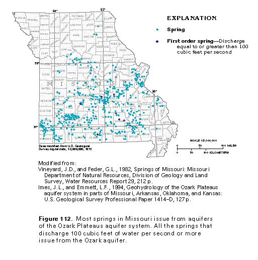
Missouri has eight first-order springs, or springs that have a flow that is greater than or equal to 100 cubic feet per second. The location of these springs is shown in figure 112, along with the location of smaller springs. All the first-order springs and most of the smaller springs mapped issue from the Ozark aquifer (compare figs. 95 and 112). Some springs, however, issue from the Springfield Plateau and the Cambrian-Ordovician aquifers. The springs are fed by conduits that developed by partial dissolution of the limestone and dolomite that compose the aquifers. Fractures and joints in the carbonate rocks also channel water to the springs. Water from many springs is used to supply fish hatcheries, and some springs are used as a partial source of municipal water supply. The chemical quality of spring water usually is suitable for most purposes, but the water is susceptible to contamination because in many places, the springs are connected to sinkholes by networks of solution openings. Thus, any contaminants that enter the aquifer can be quickly transported to a spring, as in the case of the sewage lagoon at West Plains, Missouri, discussed previously.
FRESH GROUND-WATER WITHDRAWALS
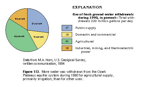
Total fresh ground-water withdrawals from the Ozark Plateaus aquifer system during 1990 were 330 million gallons per day, 8 million gallons per day of which was withdrawn in Kansas. About 139 million gallons per day was withdrawn for agricultural purposes, the principal use (fig. 113). About 88 million gallons per day was used for public supply, and about 53 million gallons per day was withdrawn for industrial, mining, and thermoelectric power uses. Withdrawals for domestic and commercial supplies were about 50 million gallons per day.