MISSISSIPPIAN AQUIFER
MISSISSIPPIAN AQUIFER
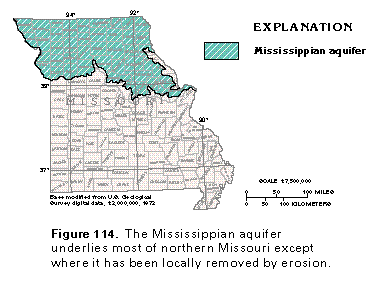
The Mississippian aquifer is the uppermost aquifer in Paleozoic rocks in northern Missouri. The aquifer extends over all of Missouri north of the Missouri River (fig. 114) except for small areas near the Mississippi and the Missouri Rivers where the rocks that compose the aquifer have been removed by erosion. Stratigraphically equivalent rocks south of the Missouri River are considered to be part of the Springfield Plateau aquifer, which is the uppermost aquifer of the Ozark Plateaus aquifer system. The Mississippian and the Springfield Plateau aquifers possibly are hydraulically connected in the Saline-Chariton-Howard-Cooper County area but are hydraulically separate elsewhere. Because this connection is poorly known, the aquifers are considered to have separate ground-water flow systems in this report.
The Mississippian aquifer is so named because it consists of limestone of Mississippian age. The Keokuk, the Burlington, the Fern Glen, the Sedalia, and the Chouteau Limestones compose the aquifer; of these formations, the Keokuk and the Burlington are the principal water-yielding rocks. Both formations consist of crystalline limestone and yield water primarily from solution cavities. In most places, the aquifer is overlain by a confining unit of Pennsylvanian shale and sandstone and is everywhere underlain by a confining unit of Mississippian shale.
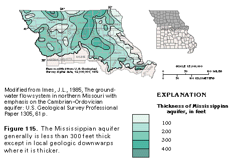
The thickness of the Mississippian aquifer averages about 200 feet but locally exceeds 400 feet in northwestern Missouri (fig. 115). The aquifer is thickest in part of the Forest City Basin, which is a structural downwarp that extends northward into Iowa, and is thinnest near the Mississippi and the Missouri Rivers where it has been dissected or partially removed by erosion.
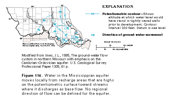
Ground-water movement in the Mississippian aquifer can be inferred from a map of the potentiometric surface of the aquifer (fig. 116). The map was prepared by using the earliest water levels available for wells completed in the aquifer, in order to represent conditions before the aquifer was developed. Recharge to the aquifer is mostly from precipitation that falls on areas where the aquifer is exposed at the land surface or is overlain by a thin blanket of younger rocks or glacial deposits, or both. Locally, the Mississippian aquifer receives some recharge by vertical leakage from the overlying glacial drift aquifers or the deeper Cambrian-Ordovician aquifer where the hydraulic head in the Mississippian aquifer is less than that of the adjacent aquifers. Most of the water in the Mississippian aquifer moves along flow paths that are of short or intermediate length from the three high areas on the potentiometric surface toward small to large streams, into which it discharges as base flow (fig. 116). The irregular shape of the potentiometric surface largely reflects the topography of the area.
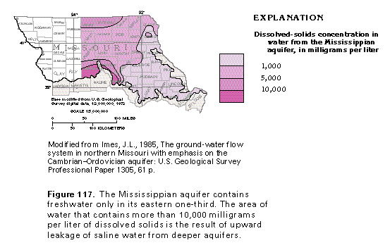
The chemical quality of the water in the Mississippian aquifer varies considerably. The aquifer contains freshwater only in the eastern one-third of its extent (fig. 117); elsewhere, it contains slightly saline to very saline water. Dissolved-solids concentrations of water from the aquifer generally are greatest where the aquifer is overlain by a thick confining unit and least where it is unconfined or overlain by a thin or leaky confining unit. In southern Carroll and Chariton Counties and western Howard County, the aquifer contains water with dissolved-solids concentrations of greater than 10,000 milligrams per liter. This very saline water is thought to have entered the Mississippian aquifer either by upward leakage from the underlying Cambrian-Ordovician aquifer or by the discharge of eastward-moving saline water from the upper aquifer unit of the Western Interior Plains aquifer system.