GROUND WATER ATLAS of the UNITED STATES
Oklahoma, Texas
HA 730-E
Edwards-Trinity aquifer system
There are two different files for each illustration
- A 72 ppi GIF file, suitable for screen viewing is accessed through
the thumbnail image
- An eps file, suitable for downloading to be printed or edited is accessed
through the "eps file" link. Most files are Adobe Illustrator
6.0, exceptions are noted. These files have been compressed with GNU's
gzip utility. If your web browser defaults to a screen display of the file,
turn on the "Load to local disk" option before downloading. Download
and process these eps files as ascii, not binary.
Edwards aquifer
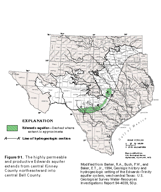
Figure 91 Map showing extent of aquifer (50K)
 editable eps file E091.eps.gz
(314K compressed)
editable eps file E091.eps.gz
(314K compressed)
Hydrogeologic framework
Figure 92 Photo of Edwards aquifer research project (83K)
 This illustration contains a placed image. Download the Adobe Illustrator
6 eps file E092.eps.gz (8.9M compressed)
which contains an imbedded Adobe Photoshop 3 (eps) file. You may also want
to download the editable Photoshop
file E092psh.eps.gz (8.9M compressed)
This illustration contains a placed image. Download the Adobe Illustrator
6 eps file E092.eps.gz (8.9M compressed)
which contains an imbedded Adobe Photoshop 3 (eps) file. You may also want
to download the editable Photoshop
file E092psh.eps.gz (8.9M compressed)
Figure 93 Cross section of aquifer (33K)
 editable eps file E093.eps.gz
(50K compressed)
editable eps file E093.eps.gz
(50K compressed)
Figure 94 Cross section of aquifer (33K)
 editable eps file E094.eps.gz
(50K compressed)
editable eps file E094.eps.gz
(50K compressed)
Figure 95 Cross section of aquifer (33K)
 editable eps file E095.eps.gz
(50K compressed)
editable eps file E095.eps.gz
(50K compressed)
Figure 96 Map showing thickness of the aquifer (33K)
 editable eps file E096.eps.gz
(83K compressed)
editable eps file E096.eps.gz
(83K compressed)
Figure 97 Map showing base-of-aquifer contour (33K)
 editable eps file E097.eps.gz
(66K compressed)
editable eps file E097.eps.gz
(66K compressed)
Figure 98 Map showing structure contour (33K)
 editable eps file E098.eps.gz
(83K compressed)
editable eps file E098.eps.gz
(83K compressed)
Ground-water movement, recharge, and discharge
Figure 99 Map showing potentiometric contour (33K)
 editable eps file E099.eps.gz
(99K compressed)
editable eps file E099.eps.gz
(99K compressed)
Figure 100 Map showing faults in the aquifer (33K)
 editable eps file E100.eps.gz
(66K compressed)
editable eps file E100.eps.gz
(66K compressed)
Figure 101 Map showing potentiometric contours in
Medina and Uvalde counties during winter of 1973 (33K)
 editable eps file E101.eps.gz
(33K compressed)
editable eps file E101.eps.gz
(33K compressed)
Figure 102 Cross section showing runoff in the aquifer system
(33K)
 editable eps file E102.eps.gz
(33K compressed)
editable eps file E102.eps.gz
(33K compressed)
Figure 103 Photo of sinkhole (50K)
 This illustration contains a placed image. Download the Adobe Illustrator
6 eps file E103.eps.gz (6.3M compressed)
which contains an imbedded Adobe Photoshop 3 (eps) file. You may also want
to download the editable Photoshop
file E103psh.eps.gz (6.3M compressed)
This illustration contains a placed image. Download the Adobe Illustrator
6 eps file E103.eps.gz (6.3M compressed)
which contains an imbedded Adobe Photoshop 3 (eps) file. You may also want
to download the editable Photoshop
file E103psh.eps.gz (6.3M compressed)
Figure 104 Graph of recharge, spring discharge, and well
discharge (17K)
 editable eps file E104.eps.gz
(17K compressed)
editable eps file E104.eps.gz
(17K compressed)
Figure 105 Photo of spring (50K)
 This illustration contains a placed image. Download the Adobe Illustrator
6 eps file E105.eps.gz (5.2M compressed)
which contains an imbedded Adobe Photoshop 3 (eps) file. You may also want
to download the editable Photoshop
file E105psh.eps.gz (5.2M compressed)
This illustration contains a placed image. Download the Adobe Illustrator
6 eps file E105.eps.gz (5.2M compressed)
which contains an imbedded Adobe Photoshop 3 (eps) file. You may also want
to download the editable Photoshop
file E105psh.eps.gz (5.2M compressed)
Figure 106 Map showing major springs in the aquifer (33K)
 editable eps file E106.eps.gz
(165K compressed)
editable eps file E106.eps.gz
(165K compressed)
Ground-water development
Table 6 Table listing withdrawals from the aquifer by county (17K)
 editable eps file Etab6.eps.gz
(17K compressed)
editable eps file Etab6.eps.gz
(17K compressed)
Fresh ground-water withdrawals
Figure 107 Chart showing the use of fresh ground-water withdrawals during
1985 (17K)
 editable eps file E107.eps.gz
(17K compressed)
editable eps file E107.eps.gz
(17K compressed)
 editable eps file E091.eps.gz
(314K compressed)
editable eps file E091.eps.gz
(314K compressed) 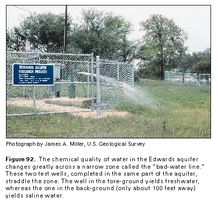 This illustration contains a placed image. Download the Adobe Illustrator
6 eps file E092.eps.gz (8.9M compressed)
which contains an imbedded Adobe Photoshop 3 (eps) file. You may also want
to download the editable Photoshop
file E092psh.eps.gz (8.9M compressed)
This illustration contains a placed image. Download the Adobe Illustrator
6 eps file E092.eps.gz (8.9M compressed)
which contains an imbedded Adobe Photoshop 3 (eps) file. You may also want
to download the editable Photoshop
file E092psh.eps.gz (8.9M compressed) 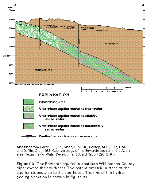 editable eps file E093.eps.gz
(50K compressed)
editable eps file E093.eps.gz
(50K compressed) 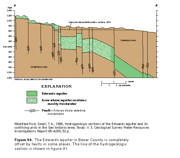 editable eps file E094.eps.gz
(50K compressed)
editable eps file E094.eps.gz
(50K compressed) 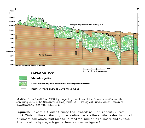 editable eps file E095.eps.gz
(50K compressed)
editable eps file E095.eps.gz
(50K compressed) 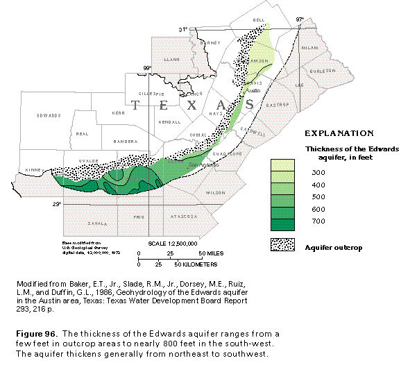 editable eps file E096.eps.gz
(83K compressed)
editable eps file E096.eps.gz
(83K compressed) 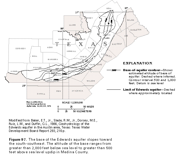 editable eps file E097.eps.gz
(66K compressed)
editable eps file E097.eps.gz
(66K compressed) 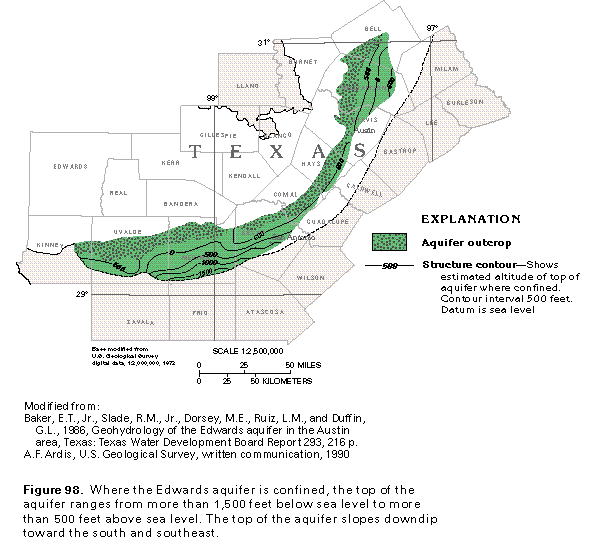 editable eps file E098.eps.gz
(83K compressed)
editable eps file E098.eps.gz
(83K compressed) 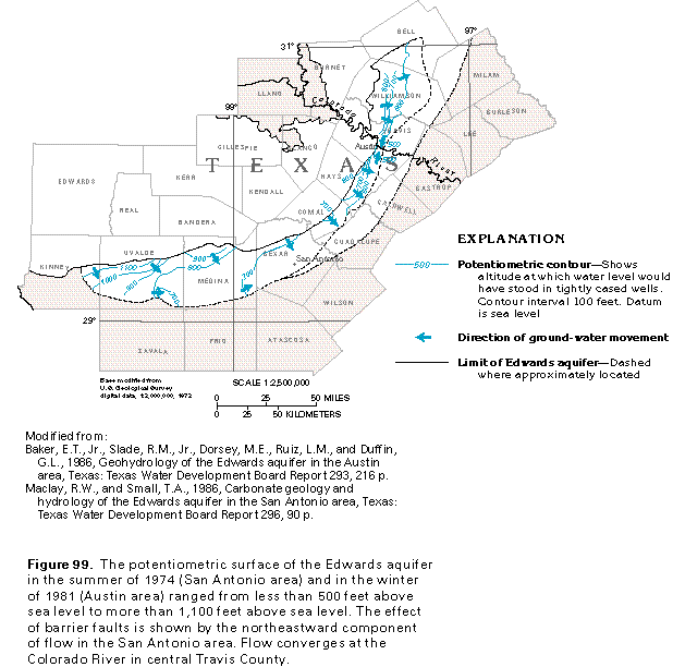 editable eps file E099.eps.gz
(99K compressed)
editable eps file E099.eps.gz
(99K compressed) 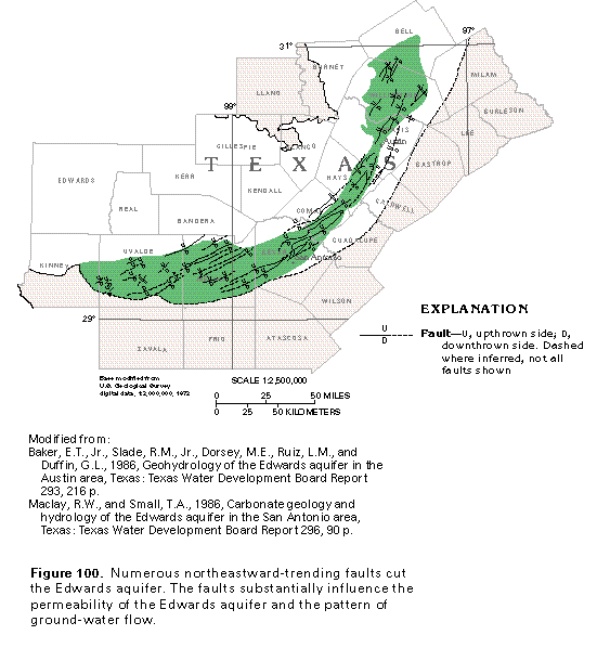 editable eps file E100.eps.gz
(66K compressed)
editable eps file E100.eps.gz
(66K compressed)  editable eps file E101.eps.gz
(33K compressed)
editable eps file E101.eps.gz
(33K compressed) 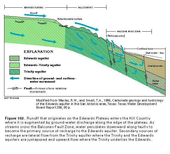 editable eps file E102.eps.gz
(33K compressed)
editable eps file E102.eps.gz
(33K compressed) 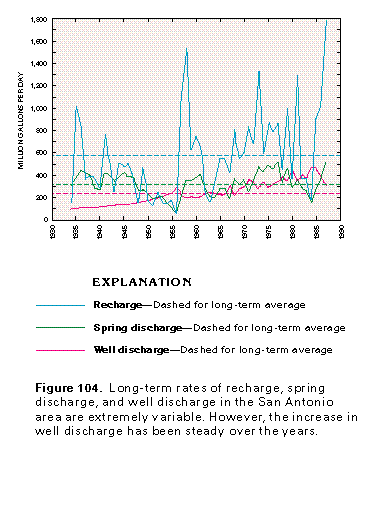 editable eps file E104.eps.gz
(17K compressed)
editable eps file E104.eps.gz
(17K compressed) 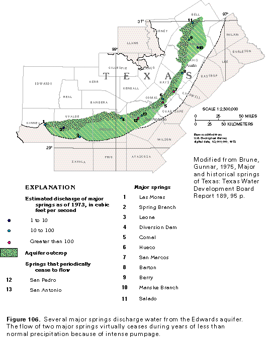 editable eps file E106.eps.gz
(165K compressed)
editable eps file E106.eps.gz
(165K compressed) 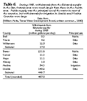 editable eps file Etab6.eps.gz
(17K compressed)
editable eps file Etab6.eps.gz
(17K compressed) 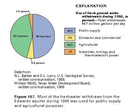 editable eps file E107.eps.gz
(17K compressed)
editable eps file E107.eps.gz
(17K compressed)