GROUND WATER ATLAS of the UNITED STATES
Arkansas, Louisiana, Mississippi
HA 730-F
Mississippi embayment aquifer system
There are two different files for each illustration
- A 72 ppi GIF file, suitable for screen viewing is accessed through
the thumbnail image
- An eps file, suitable for downloading to be printed or edited is accessed
through the "eps file" link. Most files are Adobe Illustrator
6.0, exceptions are noted. These files have been compressed with GNU's
gzip utility. If your web browser defaults to a screen display of the file,
turn on the "Load to local disk" option before downloading. Download
and process these eps files as ascii, not binary.
Middle Claiborne aquifer
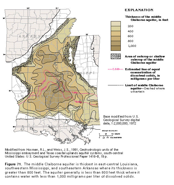
Figure 71 Map showing extent of the aquifer system (97K)
 editable eps file F071.eps.gz
(291K compressed)
editable eps file F071.eps.gz
(291K compressed)
Relation between geology and permeability
Figure 72 Map showing extent of the aquifer system (97K)
 editable eps file F072.eps.gz
(388K compressed)
editable eps file F072.eps.gz
(388K compressed)
Figure 73 Map showing extent of the aquifer system
(97K)
 editable eps file F073.eps.gz
(97K compressed)
editable eps file F073.eps.gz
(97K compressed)
Figure 74 Map showing extent of the aquifer system
(97K)
 editable eps file F074.eps.gz
(388K compressed)
editable eps file F074.eps.gz
(388K compressed)
Well yield
Ground-water flow
Figure 75 Map showing extent of the aquifer system (97K)
 editable eps file F075.eps.gz
(388K compressed)
editable eps file F075.eps.gz
(388K compressed)
Figure 76 Map showing extent of the aquifer system
(97K)
 editable eps file F076.eps.gz
(388K compressed)
editable eps file F076.eps.gz
(388K compressed)
Ground-water quality
Figure 77 Map showing extent of the aquifer system (97K)
 editable eps file F077.eps.gz
(388K compressed)
editable eps file F077.eps.gz
(388K compressed)
Figure 78 Map showing extent of the aquifer system
(97K)
 editable eps file F078.eps.gz
(388K compressed)
editable eps file F078.eps.gz
(388K compressed)
 editable eps file F071.eps.gz
(291K compressed)
editable eps file F071.eps.gz
(291K compressed)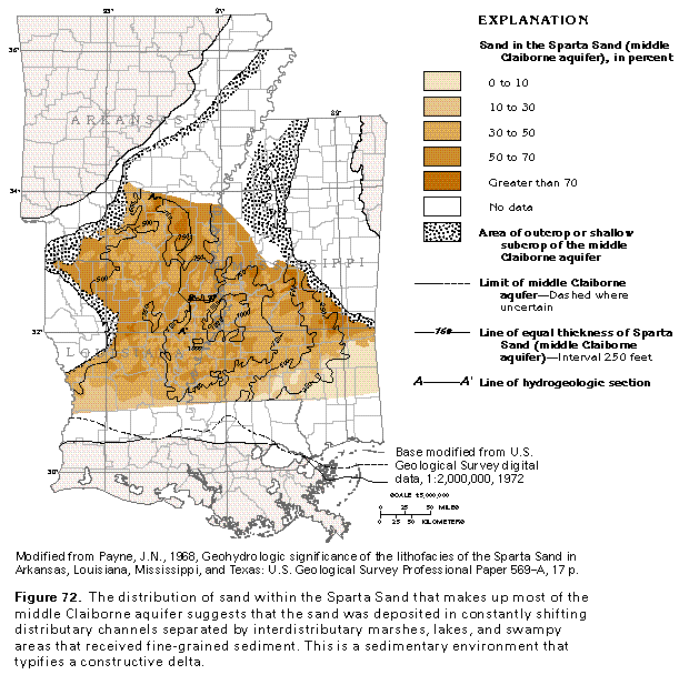 editable eps file F072.eps.gz
(388K compressed)
editable eps file F072.eps.gz
(388K compressed) 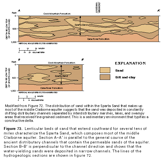 editable eps file F073.eps.gz
(97K compressed)
editable eps file F073.eps.gz
(97K compressed) 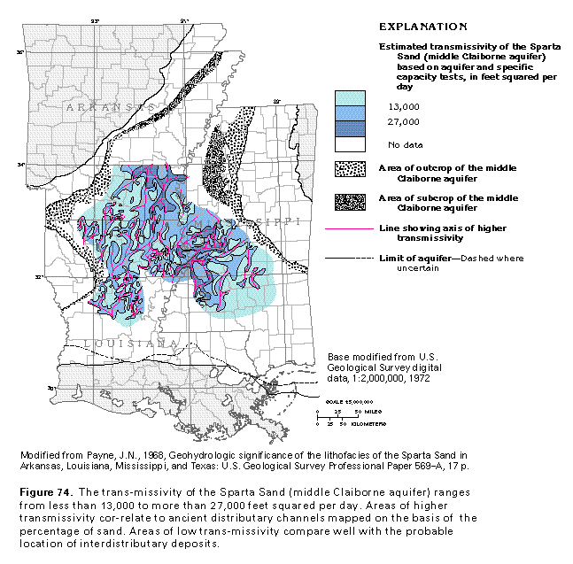 editable eps file F074.eps.gz
(388K compressed)
editable eps file F074.eps.gz
(388K compressed) 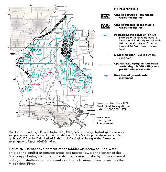 editable eps file F075.eps.gz
(388K compressed)
editable eps file F075.eps.gz
(388K compressed)  editable eps file F076.eps.gz
(388K compressed)
editable eps file F076.eps.gz
(388K compressed) 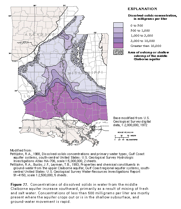 editable eps file F077.eps.gz
(388K compressed)
editable eps file F077.eps.gz
(388K compressed) 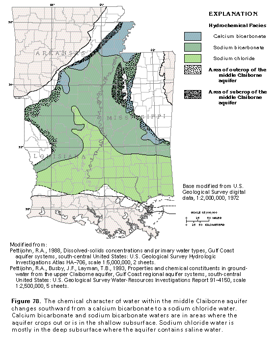 editable eps file F078.eps.gz
(388K compressed)
editable eps file F078.eps.gz
(388K compressed)