INTRODUCTION
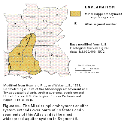
The Mississippi embayment aquifer system is the most extensive aquifer system in Segment 5, and parts of the system are discussed in Chapters C,D,G, and K (fig. 65) of this Atlas. The system underlies most of the East and West Gulf Coastal Plains and the Mississippi Alluvial Plain Sections of the Coastal Plain Province. The Mississippi embayment aquifer system merges eastward in Mississippi and in Alabama with the Pearl River aquifer that is part of the Southeastern Coastal Plain aquifer system (see Chapter G of this Atlas) and merges westward with the Coastal uplands aquifer system in Texas and Oklahoma (see Chapter E of this Atlas). A small area of equivalent rocks in southwestern Arkansas and northwestern Louisiana has been mapped as part of the Texas coastal uplands aquifer system in some reports but is considered to be part of the Mississippi embayment aquifer system in this Atlas.
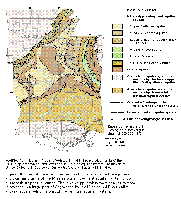
The Mississippi embayment aquifer system extends eastward from Arkansas to northwestern Mississippi and comprises six aquifers that crop out as an arcuate band of poorly consolidated to unconsolidated, bedded sand, silt and clay (fig. 66). Geologic units of the aquifer system range from Late Cretaceous to middle Eocene in age. In southern Mississippi and central Louisiana, an extensive, thick, clay confining unit, the Vicksburg-Jackson confining unit, separates the Mississippi embayment aquifer system from the overlying Oligocene and younger water-yielding strata of the coastal lowlands aquifer system. In the embayed part of the Gulf Coastal Plain of eastern Arkansas, northeastern Louisiana, and northwestern Mississippi, the southward-dipping strata of the Mississippi embayment aquifer system are hydraulically connected to the Mississippi River Valley alluvial aquifer.
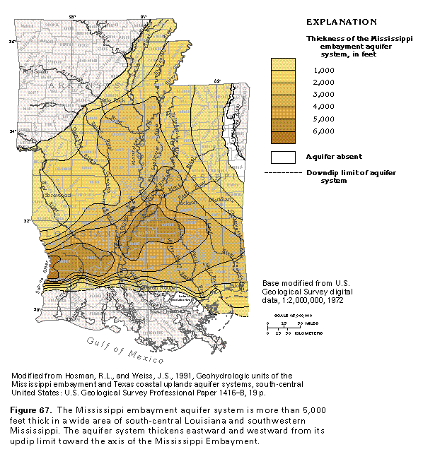
The geologic formations and groups that compose the Mississippi embayment aquifer system thicken greatly in southern Mississippi and Louisiana (fig. 67) where large volumes of sediment were deposited by streams that emptied into the ancestral Gulf of Mexico. The Mississippi embayment aquifer system ranges in thickness from a featheredge to more than 6,000 feet (fig. 67). The aquifer system thickens eastward and westward from its updip limits toward the axis of the Mississippi Embayment. The aquifer system is thickest in south-central Louisiana and southwestern Mississippi. Three of the system's six aquifers, the upper and the middle Claiborne and the lower Claiborne-upper Wilcox aquifers, become increasingly clayey and pinch out to the south (fig. 68). Some of the clayey confining units pinch out northward as they become increasingly sandy and more permeable.
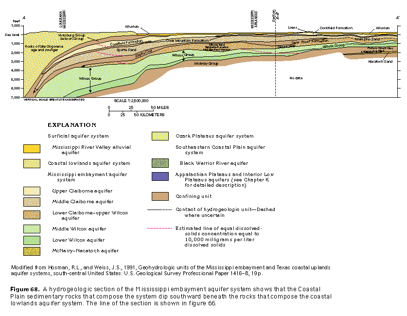
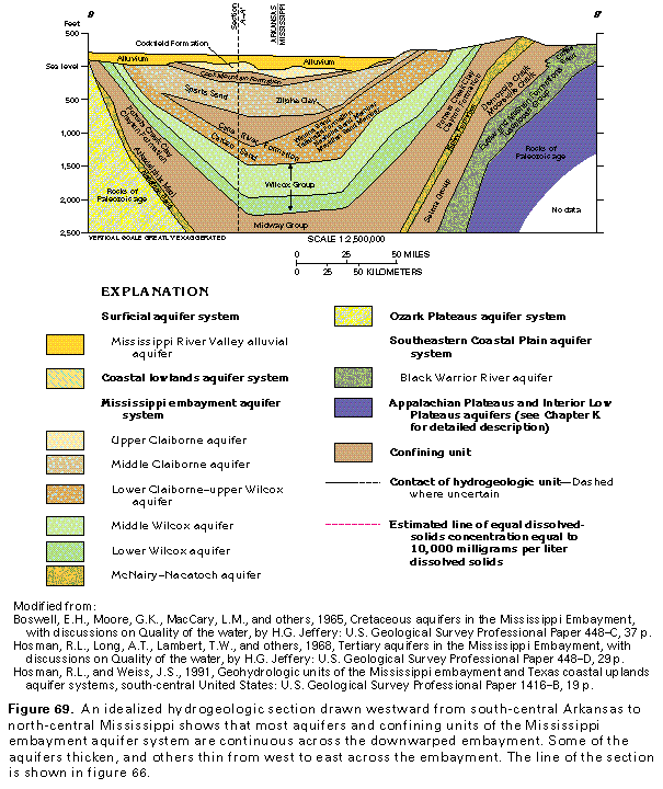
A different perspective of the geologic and hydrogeologic units that make up the aquifer system is shown in a section that crosses the central part of the Mississippi Embayment (fig. 69). Some of the aquifers (for example, the lower Claiborne-upper Wilcox aquifer) thicken eastward across the embayment locally, the middle Claiborne, the lower Claiborne-upper Wilcox, and the middle and the lower Wilcox aquifers are in direct hydraulic contact near the western side of the embayment.
HYDROGEOLOGIC UNITS
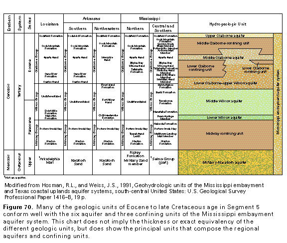
The Mississippi embayment aquifer system is divided into nine hydrogeologic units-six regional aquifers and three regional confining units. Thick, regionally-extensive clay and shale confining units separate some parts of the aquifer system into distinct, regionally mappable aquifers that are largely homogeneous sand. Other parts of the aquifer system lack regional confining units, and the regional aquifers in these parts are defined on the basis of different geohydrologic characteristics. The contacts of many aquifers and confining units within the Mississippi embayment aquifer system conform well to the contacts of geologic units (fig. 70). For example, the Midway confining unit coincides exactly with the different geologic formations that compose the Midway Group, and the upper Claiborne aquifer is identical to the Cockfield Formation. For some hydrogeologic units, however, particularly those that include rocks of the Claiborne Group, there is little or no equivalency with geologic units. The conformance of aquifers and confining units with geologic units also departs markedly as the Mississippi embayment aquifer system merges eastward with the Southeastern Coastal Plain aquifer system, which is described in Chapter G of this Atlas.
The extensive Jackson-Vicksburg confining unit is formed by massive clay beds and separates the Mississippi embayment system from the overlying coastal lowlands aquifer system. The Midway confining unit within the Mississippi embayment aquifer system also consists of massive clay beds and separates the aquifers in sediments of Tertiary age from underlying aquifers of rocks of Cretaceous age. Although the uppermost aquifers of the Mississippi embayment aquifer system, the upper and the middle Claiborne aquifers, are bounded above and below by confining units in most places, the lower Claiborne-upper Wilcox aquifer and the middle and the lower Wilcox aquifers are not separated by confining units. Sandy strata of the Wilcox Group are more heterogeneous than other rocks of Tertiary age and consist of a highly variable sequence of massive to thinly bedded sand and thin clay beds that are part of the three aquifers. The middle Wilcox aquifer differs considerably from overlying and underlying aquifers because its thin beds of sand and clay result in lower hydraulic conductivity than that of the massive, more permeable strata that lie above and below it.
Of the six aquifers contained within the Mississippi em-bayment aquifer system, the middle Claiborne aquifer is the most heavily used. Consequently, the description of the Mississippi embayment aquifer system in this chapter principally focuses on the hydrogeologic, hydraulic, and hydrochemical characteristics of the middle Claiborne aquifer. The McNairy-Nacatoch aquifer of this system also is described because the ground-water flow system is quite different from that of the other aquifers in this aquifer system.
MIDDLE CLAIBORNE AQUIFER
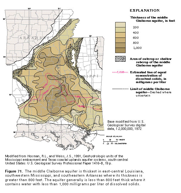
The middle Claiborne aquifer comprises mostly the Sparta Sand but also includes the Memphis Sand in the northern part of the Mississippi Embayment. In this area, the Memphis Sand is equivalent to the Sparta Sand, the Cane River Formation, and the Carrizo Sand/Meridan Sand Member of the Tallahatta Formation (fig. 70). The aquifer is thickest in a large area of east-central Louisiana and southwestern Mississippi, and in a smaller area of southeastern Arkansas (fig. 71). Although its thickness is greater than 1,000 feet in Louisiana and Mississippi, the aquifer largely contains water with more than 1,000 milligrams per liter dissolved solids. Such highly mineralized water is considered to be unsuitable for most purposes. In most areas where water in the middle Claiborne aquifer contains smaller concentrations of dissolved solids, the thickness of the aquifer generally ranges from 200 to 800 feet.
Confining units separate the middle Claiborne aquifer from overlying and underlying aquifers in most places. These confining units comprise prodelta and marine shelf deposits of clay, mud, marl, and shale. The lower Claiborne confining unit (the Cane River Formation) which underlies the middle Claiborne aquifer, and the middle Claiborne confining unit (the Cook Mountain Formation), which overlies the aquifer, were deposited as a result of widespread marine invasions that interrupted progradation of clastic sediments into the Gulf Coast Basin. Clay and shale of the lower Claiborne confining unit coarsens northward and grades to sandy channel sediments (the Winona Sand and the Tallahatta Formation) deposited in a coastal margin delta system. The predominantly marine clay facies of the lower Claiborne confining unit thus changes to an updip sand facies that forms part of the middle Claiborne aquifer. In Arkansas and northernmost Mississippi, where the lower Claiborne confining unit is missing, the middle Claiborne aquifer and the lower Claiborne-upper Wilcox aquifers function as a single aquifer, which is known locally as the Memphis aquifer.
Relation Between Geology And Permeability
Basinwide changes in geologic facies have been shown in preceding sections of this chapter to be a principal factor that controls the hydraulic character of the surficial and the coastal lowlands aquifer systems. A similar relation exists for the Mississippi embayment aquifer system. Aquifers of the Mississippi embayment aquifer system consist of an interbedded sequence of poorly consolidated fluvial, deltaic, and marine deposits in which diagenesis or postdepositional geochemical processes have not greatly altered the original pattern of permeability. The hydraulic conductivity of the unconsolidated to poorly consolidated sediments that compose the aquifers of the Mississippi embayment aquifer system does not appear to have been greatly reduced by cementation or compaction. Consequently, the distribution of hydraulic conductivity and transmissivity of the Mississippi embayment aquifer system can be inferred from maps of sediment lithofacies, if a direct correlation between sediment type and aquifer permeability is assumed.
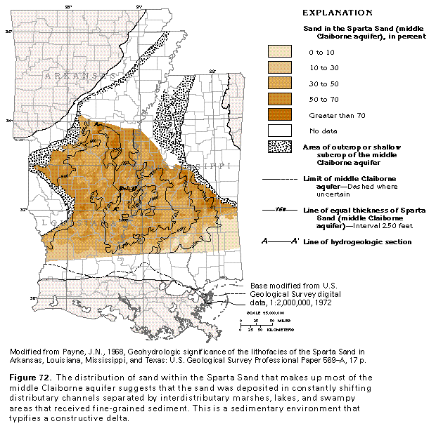
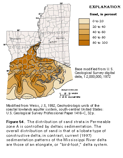
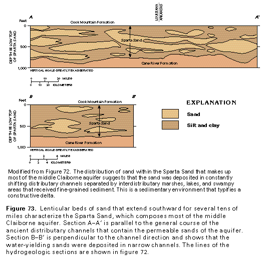
The Sparta Sand that composes most of the middle Claiborne aquifer in Louisiana and Mississippi (fig. 72) was deposited within a constructional delta system. A constructional delta system is characterized by a large-scale complex of elongate and lobate deltas formed by rivers with large discharge and sediment loads; the delta progrades into ocean water. Constructive delta systems contain mostly fluvial and deltaic facies in which coarser sediment is concentrated in landward fluvial tributaries or meandering channels and as deltaic distributaries and delta front-sand bodies. Distributary channels that contain permeable sand are separated by less permeable interdistributary clay (fig. 54). In constructional delta systems, fluvially transported sand, silt, and clay are deposited near the coast at a rate that exceeds the rate at which they are removed by wave energy and longshore currents. The meandering fluvial channel facies is characterized by wide, uniform, multilateral sand bodies with little clay content. The distributary channel facies differs in terms of its sand content and pattern of sedimentation. Channel sand bodies within the delta plain show a distributary pattern of sedimentation and do not show extensive lateral migration. Distributary channels are effectively isolated by the weight of sandy channel sediment, which causes compactional subsidence. Eventually, channel progradation results in its overextension, and the distributary channel shifts position by abandonment and diversion of floodwaters to an area with a steeper gradient. Younger distributary channels may overlap older channels as the delta builds up thick sequences of complexly interbedded deposits.
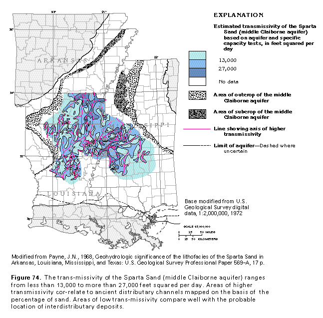
Distributary deposits are in the middle Claiborne aquifer as elongate bodies separated by areas almost devoid of sand that represent interdistributary deposits (fig. 72). The distribution of sand in the middle Claiborne aquifer, expressed as a percentage of the total thickness of the aquifer, suggests that sand was deposited within a distributary channel facies of a constructive delta system. Distributary channels of the middle Claiborne aquifer area characterized by high concentrations of sand (50 percent or greater) that extend as narrow, slightly meandering, elongate sand bodies (fig. 73). Interdistributary deposits contain from 30 to 50 percent sand and consist primarily of silt, clay, and lignite. Distributary and interdistributary channel lithofacies grade gulfward to prodelta silt and mud, which contains small concentrations of sand (less than 30 percent). The sandy channel sediments represent the most permeable parts of the middle Claiborne aquifer in Louisiana and Mississippi. The predominant direction of the distributary channels is southward or southwestward. Comparison of sand percentage and the distribution of transmissivity in the middle Claiborne aquifer (Sparta Sand) suggests that the more transmissive parts of the aquifer correspond to its sandier parts, which are interpreted as distributary channel facies (compare figs. 72 and 74). In these areas, transmissivity is more than 13,000 feet squared per day generally and locally exceeds 27,000 feet squared per day. Less transmissive sediments appear to be associated with the interdistributary channel facies that contain smaller percentages of sand. In the poorly transmissive areas, transmissivity is reported to be less than 13,000 feet per day.
Well Yield
The middle Claiborne aquifer is capable of yielding water to properly constructed wells at a rate that ranges from 100 to 300 gallons per minute in Louisiana and Mississippi. Wells screened in the middle Claiborne aquifer in Arkansas are reported to yield from 300 to 1,000 gallons per minute. Yields of as much as 2,000 gallons per minute are obtained in northernmost Mississippi and eastern Arkansas where the middle Claiborne aquifer merges with the lower Claiborne-upper Wilcox aquifer and is known locally as the Memphis aquifer.
Ground-water Flow
Gravity is the principal driving force for ground-water movement within the Mississippi embayment aquifer system. Regional movement of water in the aquifer system is from aquifer recharge areas that range from 100 to 400 feet higher than the uniformly low, flat terrain of the Mississippi Alluvial Plain where water discharges. This difference in altitude provides the gravitational energy needed to drive the ground-water flow system.
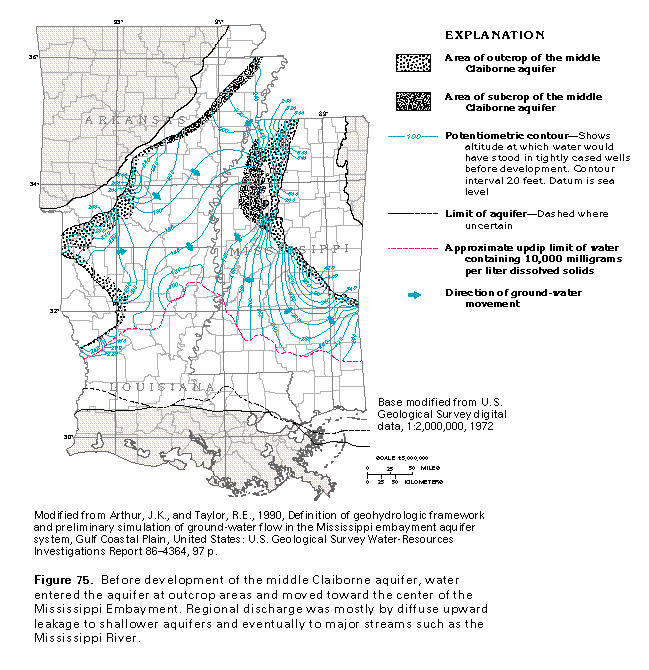
Most of the precipitation that falls on the exposed part of the Mississippi embayment aquifer system is lost to streams and rivers as direct runoff, is returned to the atmosphere from plants and soil by processes of evapotranspiration, or discharges as baseflow to streams in the outcrop area. Before development of the aquifer, water that entered the deeper, regional flow system moved toward the center of the Mississippi Embayment (fig. 75). Water in the confined parts of the system was discharged by upward leakage into shallower aquifers, such as the Mississippi River Valley alluvial aquifer. Ultimately, ground water was discharged to streams and rivers that incised the shallower aquifers.
Development of the ground-water resources of the Mississippi embayment aquifer system has greatly modified the pre-development regional flow system. Large ground-water withdrawals in southern Arkansas and northern Louisiana have caused declines of the potentiometric surface and some changes in direction of regional predevelopment flow. Lows in the predevelopment potentiometric surface were located only in areas of natural ground-water discharge. The location of potentiometric lows has changed and now depressions are in areas with large withdrawals from wells. Pumping centers in northern Louisiana and southern Arkansas were the major sites of regional ground-water discharge from the middle Claiborne aquifer in 1980 (fig. 76). Within the middle Claiborne aquifer, large withdrawals have resulted in a long-term decline in water levels, which locally exceeds 100 feet, and have created cones of depression in several places. Declines in the potentiometric surface have helped to induce greater areal recharge and recharge from incised streams in outcrop areas. Ground water removed from storage also has contributed to the long-term decline in water levels within the aquifer. Large withdrawal rates from the middle Claiborne aquifer have induced downward leakage of water into the middle Claiborne aquifer from the upper Claiborne and the Mississippi River Valley alluvial aquifers.
Ground-water Quality
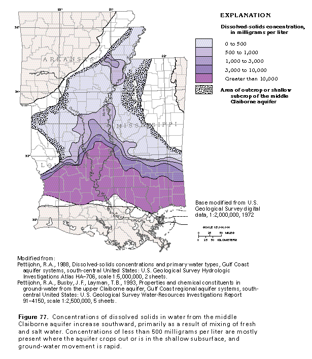
The middle Claiborne aquifer in Segment 5 contains water with less than 500 milligrams per liter dissolved solids over about one-half of its extent (fig. 77). However, the dissolved-solids concentration increases to more than 1,000 milligrams per liter where the aquifer underlies the junction of the Mississippi and the Ouachita Rivers, an area of natural ground-water discharge. The aquifer contains moderately saline water (3,000-10,000 milligrams per liter dissolved solids) in middip areas, but contains brine in the deep surface.
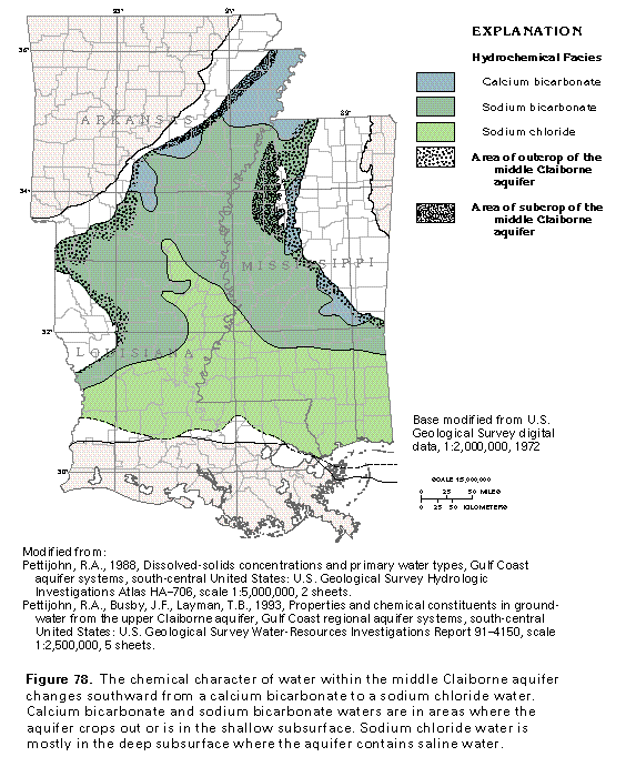
The hydrochemical character of water in the Mississippi embayment aquifer system changes progressively downgra-dient in a pattern that is consistent with the pattern of other aquifer systems in clastic Coastal Plain sediments. Chemical constituents in the ground water of clastic Coastal Plain aquifer systems are controlled, in part, by solution of the minerals in the sediments that make up the aquifers; in part, by the exchange of ions between the water and the minerals in the sediments as the water moves down the hydraulic gradient; and in part, by mixing of freshwater and saltwater in deep parts of the aquifers. The major hydrochemical facies (the dominant cations and anions) in water from the Mississippi embayment aquifer system are calcium bicarbonate, sodium bicarbonate, and sodium chloride. Other hydrochemical facies are local in extent. Calcium bicarbonate and sodium bicarbonate waters dominate the exposed and shallow subsurface areas of the middle Claiborne aquifer (fig. 78). Sodium bicarbonate water is the major type in middip subsurface areas, whereas sodium chloride water is in the deeply buried parts of the aquifer.
MCNAIRY-NACATOCH AQUIFER
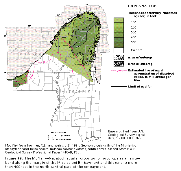
The McNairy-Nacatoch aquifer (fig. 79) comprises sand of Late Cretaceous age. The aquifer crops out or subcrops in parts of northern Mississippi and eastern and southwestern Arkansas and is the lowermost aquifer of the Mississippi embayment aquifer system. The McNairy-Nacatoch aquifer (fig. 79) extends northward into southeastern Missouri, which is described in Chapter D of this Atlas, and northeastward into western Tennessee, southern Illinois, and southwestern Kentucky, which is described in Chapter K of this Atlas. Although Missouri, Illinois, and Kentucky are not within Segment 5, the pattern of regional ground-water flow within the McNairy-Nacatoch aquifer cannot be described without also describing intersegment ground-water movement. The hydrogeology of the entire McNairy-Nacatoch aquifer is, therefore, described in this chapter.
The McNairy-Nacatoch aquifer consists of the Nacatoch Sand in Arkansas and the McNairy Sand in Mississippi. The McNairy Sand is considered to be a member of the Ripley Formation in Mississippi but is of formational rank where it extends into Tennessee and the northern part of the Mississippi Embayment. The McNairy-Nacatoch aquifer crops out as a narrow band that extends northward from Mississippi into southern Illinois and as a second narrow band in southwestern Arkansas. The aquifer subcrops beneath the Mississippi River Valley alluvial aquifer in northeastern Arkansas, southeastern Missouri, and southernmost Illinois. A confining unit separates the McNairy-Nacatoch aquifer from part of the underlying Southeastern Coastal Plain aquifer system in Mississippi, but the McNairy-Nacatoch aquifer directly overlies the Ozark Plateaus aquifer system along part of the western margin of the Coastal Plain of Arkansas and Missouri. The McNairy-Nacatoch aquifer consists of glauconitic, clayey sand deposited in a deltaic to prodeltaic environment in Arkansas and Mississippi. The aquifer is interbedded with and grades into chalk and clay as it extends southward. Deltaic deposits of sand, minor gravel, and clay compose the aquifer where it extends northward into Tennessee, southeastern Missouri, and beyond.
Ground-water Flow
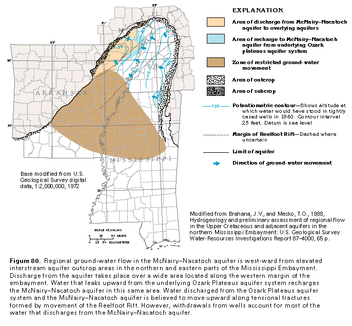
Water enters the McNairy-Nacatoch aquifer as precipitation that falls directly on the aquifer where it crops out in eastern Mississippi and the northern part of the Mississippi Embayment. Water in the aquifer moves westward from topographically high interstream areas on the northern and eastern sides of the Mississippi Embayment to a large area of regional discharge on the western side of the embayment (fig. 80). The discharge zone, which is identified by a low area of the potentiometric surface, encompasses some of the places where the McNairy-Nacatoch aquifer directly underlies the Mississippi RIver Valley alluvial aquifer in northeastern Arkansas and southeastern Missouri. The discharge zone also includes a large area where the McNairy-Nacatoch aquifer is confined by clay and shale of the Midway confining unit. Discharge of ground-water from the McNairy-Nacatoch aquifer does not coincide with any surface drainage features, but does correspond closely to an area subject to large ground-water withdrawals. The discharge area also is nearly coincident with the western margin of the Reelfoot Rift. Hydrochemical data and simulation of ground-water flow suggest that fractures and a tensional fault, both of which were caused by deep-seated, periodic crustal rifting in northeastern Arkansas, enhance vertical upward leakage of water from the Ozark Plateaus aquifer system and the McNairy-Nacatoch aquifer to shallower aquifers of the Mississippi embayment aquifer system.
Ground-water Quality
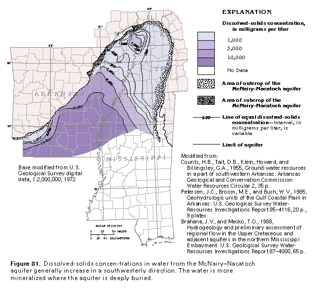
The concentration of dissolved solids in water from the McNairy-Nacatoch aquifer increases in a southwesterly direction (fig. 81). Dissolved-solids concentrations are generally lowest in areas where the aquifer crops out and where it is buried only to shallow depths. In northeastern Arkansas, dissolved-solids concentrations generally are greater than 500 milligrams per liter. Concentrations of more than 1,000 milligrams per liter are present in a small area in southeastern Missouri apparently as the result of upward leakage of water from the Ozark Plateaus aquifer system. The McNairy-Nacatoch aquifer generally contains more than 3,000 milligrams per liter dissolved-solids concentration in its deepest parts. The aquifer is dominated by sodium bicarbonate water where it contains water with less than 2,000 milligrams per liter dissolved solids and by sodium chloride water where it contains water with more than 2,000 milligrams per liter dissolved solids.
FRESH GROUND-WATER WITHDRAWALS
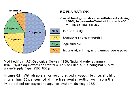
Fresh ground-water withdrawals from the Mississippi embayment aquifer system are estimated to be 433 million gallons per day (fig. 82). Public supply use accounts for about 52 percent of the total water withdrawn from the aquifer system, or about 224 million gallons per day. Withdrawals for domestic and commercial use were about 23 percent of the total withdrawals, or about 99 million gallons per day. Agricultural withdrawals from the Mississippi embayment aquifer system averaged about 71 million gallons per day, or about 16 percent of the total ground-water withdrawn. Industrial, mining, and thermoelectric power users withdrew about 39 million gallons per day, or about 9 percent of the total withdrawals.
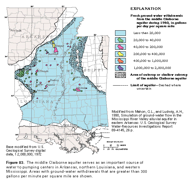
More water is withdrawn from the middle Claiborne aquifer than from any other aquifer of the Mississippi embayment aquifer system. In 1980, for example, about 308 million gallons per day was withdrawn from the aquifer principally from major pumping centers (fig. 83) in the cities of Stuttgart, Pine Bluff, El Dorado, and Magnolia, Arkansas; Ruston, Jonesboro, Monroe, and Bastrop, Louisiana, and Yazoo City and Jackson, Mississippi. Large withdrawals are also made by pumping centers in the Memphis, Tennessee area (Chapter K).