GROUND WATER ATLAS of the UNITED STATES
Arkansas, Louisiana, Mississippi
HA 730-F
Surficial aquifer system
There are two different files for each illustration
- A 72 ppi GIF file, suitable for screen viewing is accessed through
the thumbnail image
- An eps file, suitable for downloading to be printed or edited is accessed
through the "eps file" link. Most files are Adobe Illustrator
6.0, exceptions are noted. These files have been compressed with GNU's
gzip utility. If your web browser defaults to a screen display of the file,
turn on the "Load to local disk" option before downloading. Download
and process these eps files as ascii, not binary.
Hydrogeology
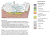
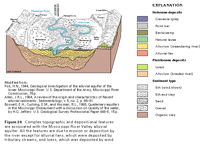
Figure 24 Diagramatic section showing Holocene, Pleistocene, and
Sedimentary deposits (97K)
 This illustration contains a placed image. Download the Adobe Illustrator
6 eps file F024.eps.gz (388K compressed)
which contains an imbedded Adobe Photoshop 3 (eps) file. You may also want
to download the editable Photoshop
file F024psh.eps.gz (291K compressed)
This illustration contains a placed image. Download the Adobe Illustrator
6 eps file F024.eps.gz (388K compressed)
which contains an imbedded Adobe Photoshop 3 (eps) file. You may also want
to download the editable Photoshop
file F024psh.eps.gz (291K compressed)
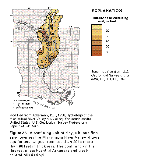
Figure 25 Map showing thickness of confining unit
(97K)
 editable eps file F025.eps.gz
(291K compressed)
editable eps file F025.eps.gz
(291K compressed)
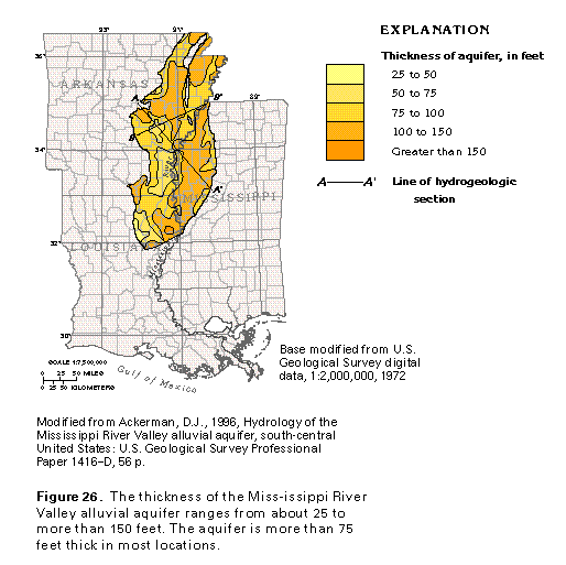
Figure 26 Map showing thickness of aquifer (97K)
 editable eps file F026.eps.gz
(291K compressed)
editable eps file F026.eps.gz
(291K compressed)
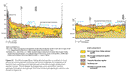
Figure 27 Hydrogeologic cross sections (97K)
 editable eps file F027.eps.gz
(97K compressed)
editable eps file F027.eps.gz
(97K compressed)
 This illustration contains a placed image. Download the Adobe Illustrator
6 eps file F024.eps.gz (388K compressed)
which contains an imbedded Adobe Photoshop 3 (eps) file. You may also want
to download the editable Photoshop
file F024psh.eps.gz (291K compressed)
This illustration contains a placed image. Download the Adobe Illustrator
6 eps file F024.eps.gz (388K compressed)
which contains an imbedded Adobe Photoshop 3 (eps) file. You may also want
to download the editable Photoshop
file F024psh.eps.gz (291K compressed)