GROUND WATER ATLAS of the UNITED STATES
Arkansas, Louisiana, Mississippi
HA 730-F
Surficial aquifer system
There are two different files for each illustration
- A 72 ppi GIF file, suitable for screen viewing is accessed through
the thumbnail image
- An eps file, suitable for downloading to be printed or edited is accessed
through the "eps file" link. Most files are Adobe Illustrator
6.0, exceptions are noted. These files have been compressed with GNU's
gzip utility. If your web browser defaults to a screen display of the file,
turn on the "Load to local disk" option before downloading. Download
and process these eps files as ascii, not binary.
River-Aquifer interaction
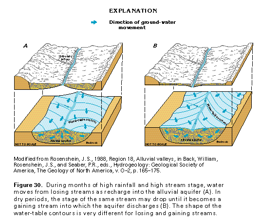
Figure 30 Diagramatic section showing ground-water movement (97K)
 This illustration contains a placed image. Download the Adobe Illustrator
6 eps file F030.eps.gz (291K compressed)
which contains an imbedded Adobe Photoshop 3 (eps) file. You may also want
to download the editable Photoshop
file F030psh.eps.gz (97K compressed)
This illustration contains a placed image. Download the Adobe Illustrator
6 eps file F030.eps.gz (291K compressed)
which contains an imbedded Adobe Photoshop 3 (eps) file. You may also want
to download the editable Photoshop
file F030psh.eps.gz (97K compressed)
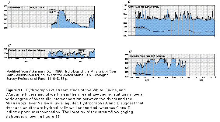
Figure 31 Hydrographs of stream stage of the White,
Cache, and L'Anguille Rivers (97K)
 editable eps file F031.eps.gz
(97K compressed)
editable eps file F031.eps.gz
(97K compressed)
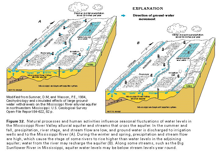
Figure 32 Diagramatic section showing ground-water
movement (97K)
 This illustration contains a placed image. Download the Adobe Illustrator
6 eps file F032.eps.gz (582K compressed)
which contains an imbedded Adobe Photoshop 3 (eps) file. You may also want
to download the editable Photoshop
file F032psh.eps.gz (291K compressed)
This illustration contains a placed image. Download the Adobe Illustrator
6 eps file F032.eps.gz (582K compressed)
which contains an imbedded Adobe Photoshop 3 (eps) file. You may also want
to download the editable Photoshop
file F032psh.eps.gz (291K compressed)
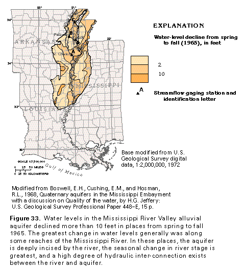
Figure 33 Map showing Water-level decline from spring
to fall in 1965 (97K)
 editable eps file F033.eps.gz
(291K compressed)
editable eps file F033.eps.gz
(291K compressed)
 This illustration contains a placed image. Download the Adobe Illustrator
6 eps file F030.eps.gz (291K compressed)
which contains an imbedded Adobe Photoshop 3 (eps) file. You may also want
to download the editable Photoshop
file F030psh.eps.gz (97K compressed)
This illustration contains a placed image. Download the Adobe Illustrator
6 eps file F030.eps.gz (291K compressed)
which contains an imbedded Adobe Photoshop 3 (eps) file. You may also want
to download the editable Photoshop
file F030psh.eps.gz (97K compressed)