GROUND WATER ATLAS of the UNITED STATES
Arkansas, Louisiana, Mississippi
HA 730-F
Surficial aquifer system
There are two different files for each illustration
- A 72 ppi GIF file, suitable for screen viewing is accessed through
the thumbnail image
- An eps file, suitable for downloading to be printed or edited is accessed
through the "eps file" link. Most files are Adobe Illustrator
6.0, exceptions are noted. These files have been compressed with GNU's
gzip utility. If your web browser defaults to a screen display of the file,
turn on the "Load to local disk" option before downloading. Download
and process these eps files as ascii, not binary.
Stream-valley alluvial aquifers
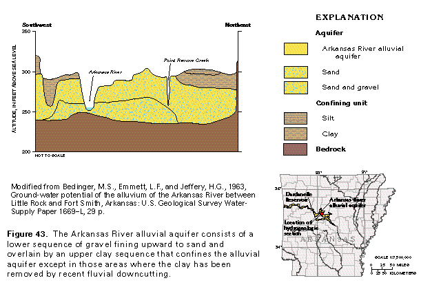
Figure 43 Hydrogeologic cross section (97K)
 editable eps file F043.eps.gz
(194K compressed)
editable eps file F043.eps.gz
(194K compressed)
Figure 44 Graph showing depth to water near the Dardanelle
Reservoir from 1958 to 1972 (97K)
 editable eps file F044.eps.gz
(97K compressed)
editable eps file F044.eps.gz
(97K compressed)
Table 1 Table listing aquifer characteristics (32K)
 editable eps file Ftab1.eps.gz
(32K compressed)
editable eps file Ftab1.eps.gz
(32K compressed)
Figure 45 Chart and table showing the chemical concentrations
for the Arkansas River alluvial aquifer (97K)
 editable eps file F045.eps.gz
(97K compressed)
editable eps file F045.eps.gz
(97K compressed)
 editable eps file F043.eps.gz
(194K compressed)
editable eps file F043.eps.gz
(194K compressed) 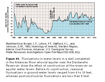 editable eps file F044.eps.gz
(97K compressed)
editable eps file F044.eps.gz
(97K compressed) 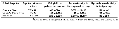 editable eps file Ftab1.eps.gz
(32K compressed)
editable eps file Ftab1.eps.gz
(32K compressed) 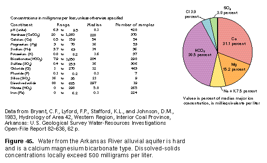 editable eps file F045.eps.gz
(97K compressed)
editable eps file F045.eps.gz
(97K compressed)